A target detection and positioning method and system for unmanned vehicles

A technology for unmanned vehicles and target detection, which is applied in the field of target detection and positioning methods and systems for unmanned vehicles, and can solve the problems of the real-time performance and detection accuracy of the target detection method, and the inability to provide the longitude and latitude coordinates of the target to be detected. , to achieve the effects of strong model customization, fast training convergence speed, and high accuracy

Active Publication Date: 2022-06-17
BEIJING INSTITUTE OF TECHNOLOGYGY
View PDF5 Cites 0 Cited by
  • Summary
  • Abstract
  • Description
  • Claims
  • Application Information

AI Technical Summary

Problems solved by technology

[0003] However, most of the current target detection and positioning methods focus on detecting the target, calculating the relative distance between the target and the vehicle itself, and cannot provide the latitude and longitude coordinates of the target to be detected in the WGS1984 coordinate system, and most methods use the real-time performance of the target detection method. The accuracy rate is relatively backward. Therefore, in order to realize the real-time detection of targets and obtain the longitude and latitude coordinates of targets in the WGS1984 coordinate system during the execution of battlefield patrol tasks and reconnaissance tasks by unmanned vehicles, the present invention proposes an unmanned vehicle-oriented Object Detection and Localization Methods

Method used


Image

  • A target detection and positioning method and system for unmanned vehicles
  • A target detection and positioning method and system for unmanned vehicles
  • A target detection and positioning method and system for unmanned vehicles

Examples


Embodiment Construction

[0063] The technical solutions in the embodiments of the present invention will be clearly and completely described below with reference to the accompanying drawings in the embodiments of the present invention. Obviously, the described embodiments are only a part of the embodiments of the present invention, rather than all the embodiments. Based on the embodiments of the present invention, all other embodiments obtained by those of ordinary skill in the art without creative efforts shall fall within the protection scope of the present invention.

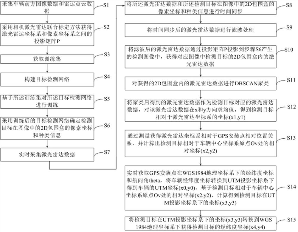
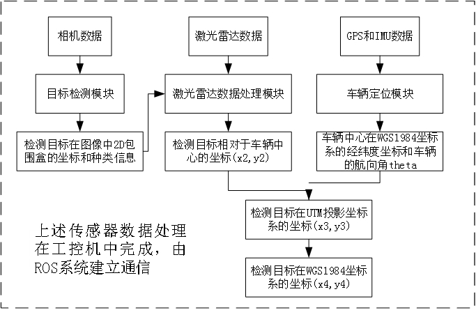
[0064] The purpose of the present invention is to provide a target detection and positioning method and system for unmanned vehicles, which can detect the target in real time and obtain the latitude and longitude coordinates of the target in the WGS1984 coordinate system.

[0065] In order to make the above objects, features and advantages of the present invention more clearly understood, the present invention will be described in fur...


PUM


Abstract

The invention relates to a target detection and positioning method and system for unmanned vehicles. The method includes: obtaining a projection matrix; determining the pixel coordinates and type information of the 2D bounding box of the detection target in the image; combining the laser radar data with the previous step Time synchronization and filtering of the information; the filtered lidar data is projected into the detection image through the projection matrix, and the lidar data in the 2D bounding box of the detection target in the corresponding image is obtained and clustered; the lidar data is in x Calculate the mean value in the y direction to obtain the coordinates of the detection target relative to the lidar coordinate system; calculate the relative coordinates of the detection target relative to the origin of the vehicle center coordinate system; obtain the UTM coordinates of the vehicle, and calculate the coordinates of the detection target in the UTM projection coordinate system , and converted to the WGS1984 geographic coordinate system. The above method in the present invention can detect the target in real time and obtain the longitude and latitude coordinates of the target in the WGS1984 coordinate system.

Description

technical field [0001] The invention relates to the field of target detection, in particular to a target detection and positioning method and system for unmanned vehicles. Background technique [0002] During patrol and reconnaissance missions, unmanned vehicles often need to detect specific targets and obtain the latitude and longitude coordinates of the target in the WGS1984 coordinate system. The acquired latitude and longitude coordinates, in addition to providing location information for long-range precision guided strikes, can also be used to make battlefield situation maps, which are of great significance for unmanned combat. [0003] At present, most methods for target detection and positioning focus on detecting the target, calculating the relative distance between the target and the vehicle itself, and cannot provide the latitude and longitude coordinates of the target to be detected in the WGS1984 coordinate system, and the target detection methods used by most me...

Claims


Application Information

Patent Timeline
Patent Type & Authority Patents(China)
IPC IPC(8): G06V20/56G06V10/762G06K9/62G06N3/04G06N3/08G01S17/86
CPCG01S17/86G06N3/08G06N3/045G06F18/23
Inventor 刘海鸥陶俊峰陈慧岩尹旻唐泽月臧政
Owner BEIJING INSTITUTE OF TECHNOLOGYGY
Why Eureka
Try Eureka