SAR (Synthetic Aperture Radar) image overlay area positioning method based on spatial geometric ratio relation

A technology for regional positioning and imaging, applied in the field of microwave remote sensing, can solve problems such as complex methods, and achieve the effect of simple and efficient methods

Pending Publication Date: 2022-05-10
WUHAN UNIV
View PDF0 Cites 2 Cited by
  • Summary
  • Abstract
  • Description
  • Claims
  • Application Information

AI Technical Summary

Problems solved by technology

To solve the overlay problem, it is first necessary to determine the position of the overlay area. The traditional overlay area positioning method needs to calculate the change of the slant distance from the target point to the sensor as the distance increases to the coordinates. The method is complex and needs to know the relevant parameters of the rigorous model.

Method used


Image

  • SAR (Synthetic Aperture Radar) image overlay area positioning method based on spatial geometric ratio relation
  • SAR (Synthetic Aperture Radar) image overlay area positioning method based on spatial geometric ratio relation
  • SAR (Synthetic Aperture Radar) image overlay area positioning method based on spatial geometric ratio relation

Examples


Embodiment Construction

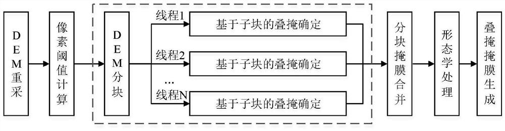
[0083] The present invention provides a SAR image overlay region positioning method based on the spatial geometric ratio relationship. The technical solution of the present invention will be further described below in conjunction with the accompanying drawings and embodiments.

[0084] like figure 1 As shown, the process of the embodiment of the present invention includes the following steps:

[0085] Step 1. Obtain the original SAR image, estimate the location according to the range of the center point of the image, and obtain the DEM data covering the corresponding area of ​​the image range.

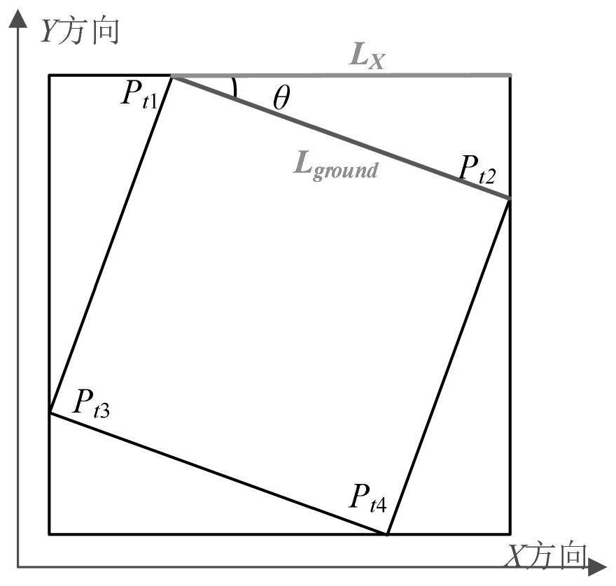
[0086] Step 2, analyze the xml file attached to the SAR image to obtain the incident angle of the image.

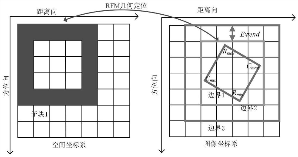
[0087] Step 3, read the RPC parameter file, and construct the rational function model of the spaceborne SAR image.

[0088] The rational function model is to express the coordinates of the image point (R, C) as the ratio of the polynomial with the earth coordinates (X, Y, Z) as ...


PUM


Abstract

The invention relates to an SAR image overlay area positioning method based on a space geometry ratio relation. The method comprises the following steps: firstly, acquiring SAR data and DEM data of a corresponding region; acquiring an image incident angle according to an xml file attached to the SAR image; reading an RPC parameter file, and constructing a rational function model RFM of the satellite-borne SAR image; geodetic coordinates corresponding to the coordinates of the image points at the four corners of the SAR image are determined, and a minimum enclosing rectangle formed by the geodetic coordinates is obtained; cutting the DEM data according to the minimum bounding rectangle, and re-sampling the DEM data; determining a ratio relation threshold value of the number of the object space pixels and the number of the image space pixels when overlay occurs; on the basis of object space partitioning of the resampling DEM data, a mask of each object space sub-block is calculated in a multi-thread parallel mode, and the masks are combined and subjected to post-processing to generate a final overlay mask. The method provided by the invention can be used for quickly generating the SAR overlay mask, and provides technical guarantee for further application of SAR images.

Description

technical field [0001] The invention belongs to the technical field of microwave remote sensing, and in particular relates to a SAR image overlapping area positioning method based on a spatial geometric ratio relationship. Background technique [0002] Synthetic Aperture Radar (SAR) is an active imaging sensor that uses microwaves to detect surface targets. It has the characteristics of all-day and all-weather imaging and can be used as an important supplement to optical remote sensing. . However, due to the characteristics of side-view geometric imaging in SAR, severe geometric distortions, such as overlapping and shadows, will occur when the terrain has large fluctuations. The degree of distortion is related to the incident angle. When the slope angle is greater than the incident angle, overlapping will occur. For overlapping and shadowing, the scattered signals from these distorted areas contain almost no information about the type of terrain coverage, which seriously a...

Claims


Application Information

Patent Timeline
Patent Type & Authority Applications(China)
IPC IPC(8): G06T7/70
CPCG06T7/70G06T2207/10044G06T2207/20021
Inventor 汪韬阳程前
Owner WUHAN UNIV
Why Eureka
Try Eureka