Area feature variation detection method based on remote sensing image and GIS data

A remote sensing image and change detection technology, applied in measurement devices, re-radiation of electromagnetic waves, radio wave measurement systems, etc., can solve the problems of uncontrollable accuracy and reliability of change detection results, blind detection process, etc., to reduce blindness, The effect of improving reliability and accuracy

Inactive Publication Date: 2006-06-21
WUHAN UNIV
View PDF0 Cites 21 Cited by
  • Summary
  • Abstract
  • Description
  • Claims
  • Application Information

AI Technical Summary

Problems solved by technology

[0004] The current general change detection method steps can be summarized as: data preprocessing, data registration, feature extraction (based on feature-level change detection methods), change detection, and result analysis. These steps are performed independently, and the errors of each step will be transmitted. To the next step, where data registration and feature extraction have a critical impact on change detection, making the accuracy and reliability of change detection results uncontrollable, and the detection process is relatively blind

Method used


Image

  • Area feature variation detection method based on remote sensing image and GIS data
  • Area feature variation detection method based on remote sensing image and GIS data
  • Area feature variation detection method based on remote sensing image and GIS data

Examples


Embodiment Construction

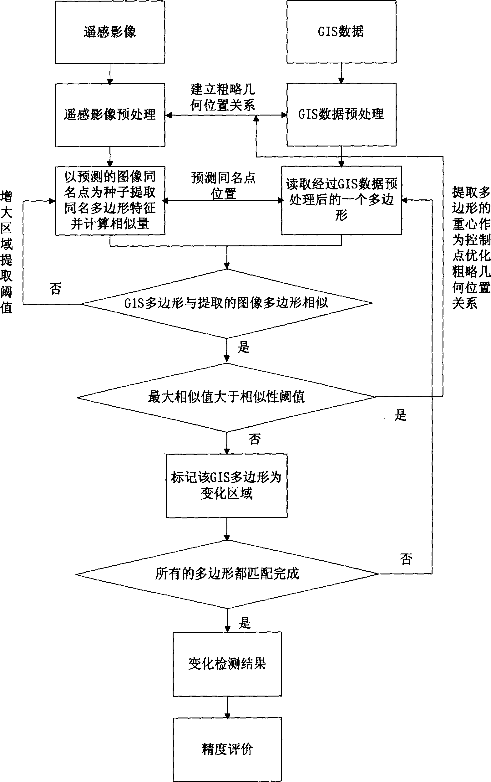
[0040] Referring to accompanying drawing, the present invention comprises the following steps:

[0041] 1. Preprocessing of GIS data

[0042] I. From the GIS data, select the surface objects expressed according to the actual mapping scale, and extract the polygons expressing their geometric shapes.

[0043] II. Calculate the area according to the polygon coordinates, and sort all the polygons by area from large to small.

[0044] III. Calculating the similarity feature amount of each group of polygons for matching. For the calculation of the similarity feature quantity, refer to the following step 4.

[0045] IV. Determine the "Label" point of the polygon. Follow the steps below for each polygon to calculate the Label points:

[0046] 1) Rasterize in computer memory according to the coordinates of each polygon to generate a binary image of the size of the rectangle circumscribing the polygon.

[0047] 2) Use the erosion operation (Erosion) in mathematical morphology to pe...


PUM


Abstract

The invention discloses a planar terrain variation detecting method based on remote sensing image and GIS data, which comprises the following steps: first, predisposing the GIS data; second, predisposing the remote sensing image; third, calculating the Label point of planar terrain; fourth, predicting the remote sensing image same-name point corresponding to the GIS planar terrain Label point; fifth, defining a group of similar character vector from coarse to fine; sixth, extracting the same name planar terrain according to the similar character vector; seventh, judging whether the terrain changes according to the similar character vector threshold value; marking the terrain if yes; calculating the gravity coordinate of the polygon as the control point then returning the fourth step if no. The invention can detect the varied terrain and obtains the control point of non-varied terrain, which utilizes the control points to accomplish the automatic registration of image and GIS data.

Description

technical field [0001] The invention belongs to the combined application field of remote sensing images and GIS (Geographic Information System), and relates to an overall iterative solution method for surface object change detection based on remote sensing images and GIS data. Background technique [0002] Changes in nature and various human activities are changing the surface landscape and its utilization forms every day. Rapid population growth and urbanization have accelerated this change. These changes will have a profound impact on the earth's resources and environment. Therefore, it is necessary to monitor surface changes in a timely and effective manner, update relevant geographic information systems, and provide scientific decision-making basis for functional departments such as resource management and planning and environmental protection. Satellite earth observation technology, developed to understand the earth, is undoubtedly the best technical means to monitor s...

Claims


Application Information

Patent Timeline
Patent Type & Authority Applications(China)
IPC IPC(8): G01S17/89
Inventor 张晓东李德仁龚健雅秦前清
Owner WUHAN UNIV
Why Eureka
Try Eureka