
Method and system for GPS enabled model and site interaction and collaboration for BIM and other design platforms

a technology of global positioning system and enabled model, applied in the field of three-dimensional models, can solve the problems of lack of standardization, long-held belief in poor bim software interoperability, and $15.8 billion lost annually by the u.s. capital facilities industry

Active Publication Date: 2020-12-15
ANGULERIS TECH
View PDF106 Cites 11 Cited by
  • Summary
  • Abstract
  • Description
  • Claims
  • Application Information

AI Technical Summary

Problems solved by technology

However, there are a number of problems associated with creating three dimensional models (3D) from two dimensional (2D) data building information modeling (BIM).
One problem is that poor BIM software interoperability has long been regarded as an obstacle to industry efficiency in general and to BIM adoption in particular.
In August 2004 the US National Institute of Standards and Technology (NIST) issued a report which conservatively estimated that $15.8 billion was lost annually by the U.S. capital facilities industry due to inadequate interoperability arising from “the highly fragmented nature of the industry, the industry's continued paper based business practices, a lack of standardization, and inconsistent technology adoption among stakeholders”.
Another problem is existing BIM 3D modeling programs cannot be easily extended for new products.
Another problem is that it is not easy to create new 3D models for existing 3D modeling programs.
Another problem is that new 3D models used on one 3D modeling program are not in a format that is directly compatible with a second 3D modeling program.
Another problem is that 3D modeling programs file formats are proprietary and are difficult to create new 3D models for.
Another problems is that it is not easy to create composite 3D models from plural 3D object models from different sources.
Another problem is that with existing 3D modeling platforms it is hard to cooperate with other users.
Another problems is that with existing 3D modeling platforms it is hard to collect useful analytics.
Another problem is that many times actual physical objects are added to a job site that do not have corresponding virtual objects in a 3D modeling program.
Another problem is that physical objects may not exist at a job site or be damaged and need replacement.
There is no way to determine this from a 3D modeling program.
However, none of these solutions solves all of the problems associated with actual and physical objects used with BIM.

Method used


Image

  • Method and system for GPS enabled model and site interaction and collaboration for BIM and other design platforms
  • Method and system for GPS enabled model and site interaction and collaboration for BIM and other design platforms
  • Method and system for GPS enabled model and site interaction and collaboration for BIM and other design platforms

Examples


Embodiment Construction

Exemplary Cloud Electronic Information Storage and Retrieval System

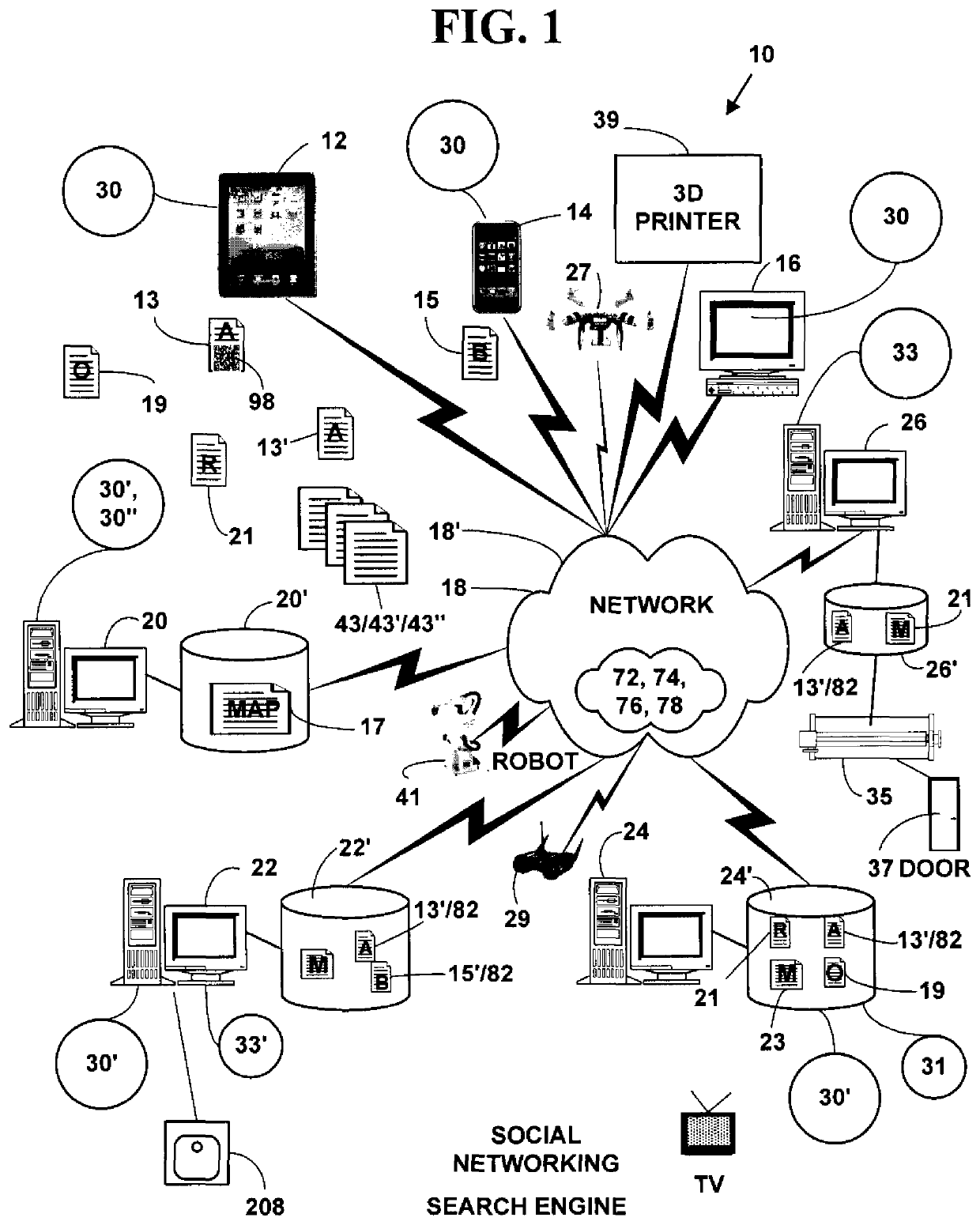
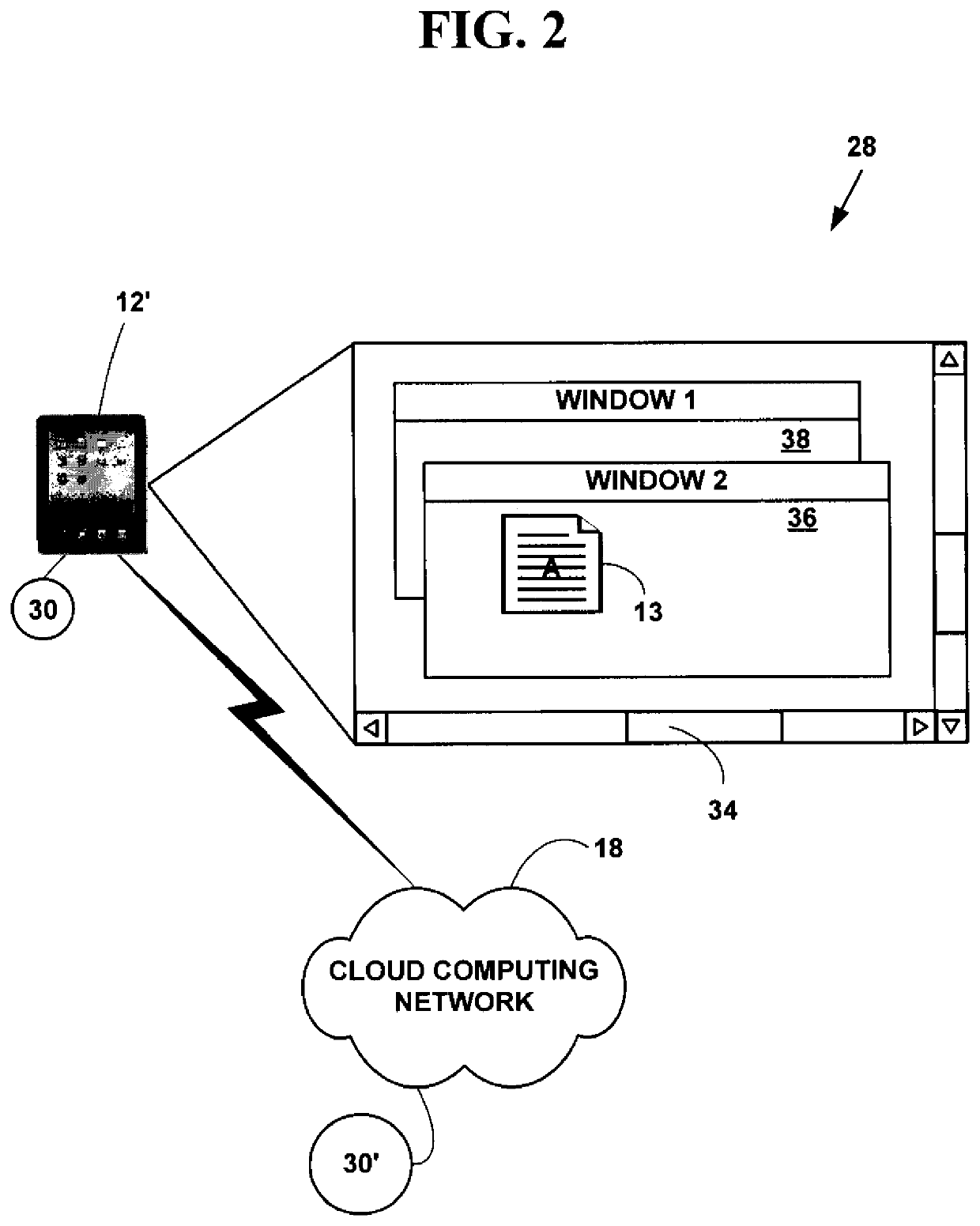
[0063]FIG. 1 is a block diagram illustrating an exemplary electronic information display system 10. The exemplary electronic system 10 includes, but is not limited to, one or more target network devices 12, 14, 16 (only three of which are illustrated) each with one or more processors and each with a non-transitory computer readable medium.

[0064]The one or more target network devices 12, 14, 16 include, but are not limited to, multimedia capable desktop and laptop computers, tablet computers, facsimile machines, mobile phones, non-mobile phones with and / or without displays, three-dimensional (3D) printer, robots, smart phones, Internet phones, Internet appliances, personal digital / data assistants (PDA), two-way pagers, digital cameras, portable game consoles (Play Station Portable by Sony, Game Boy by Sony, Nintendo DSI, etc.), non-portable game consoles (Xbox by Microsoft, Play Station by Sony, Wii by Nintendo, etc.)...


PUM


Abstract

A method and system for GPS enabled model and site interaction for Building Information Modeling (BIM) and other design platforms. Collaboration information for actual physical objects at physical locations is automatically collected and associated with virtual objects in virtual object models in a three-dimensional (3D) object modeling programs for a selected project or new virtual objects that did not previously exist are created in the 3D modeling program and associated with the actual physical objects that have been physically added to at a project site. The method and system allows two-way real-time and static collaboration between native and new composite XD (e.g., 3D, or lower or higher dimensional) object models from within existing 3D modeling BIM programs (e.g., AUTODESK REVIT, AUTOCAD, VECTORWORKS, etc.) and the actual physical objects at the actual physical locations.

Description

FIELD OF INVENTION[0001]This invention relates to creating three dimensional models that are used to create actual products. More specifically, it relates to a method and system for Global Positioning System (GPS) enabled model and site interaction for Building Information Modeling (BIM) and other design platforms.BACKGROUND OF THE INVENTION[0002]Building Information Modeling (BIM) is a process including the generation and management of digital representations of physical and functional characteristics of physical spaces. Building Information Models (BIMs) are files (often but not always in proprietary formats and containing proprietary data) which can be exchanged or networked to support decision-making.[0003]Current BIM software is used by individuals, businesses and government authorities who plan, design, construct, operate and maintain diverse physical infrastructures, from water, wastewater, electricity, gas, refuse and communication utilities to roads, bridges and ports, from...

Claims


Application Information

Patent Timeline
Patent Type & Authority Patents(United States)
IPC IPC(8): G06Q10/10G06T19/00H04L29/08G06F30/13G06F111/02
CPCH04L67/10H04L67/12G06Q10/101G06T19/00G06F30/13G06T2219/024G06F2111/02H04L65/403
Inventor GLUNZ, BENJAMIN F.
Owner ANGULERIS TECH
Learn More