System and method for abstracting and visualizing a route map

a route map and system technology, applied in the field of system and method for abstracting and visualizing a route map, can solve the problems of unsatisfactory on-line computer generated maps, inability to effectively communicate points of reorientation, and the need for uniform scaling of roads, so as to avoid map clutter in the scaled map

Inactive Publication Date: 2005-07-07
MICROSOFT TECH LICENSING LLC
View PDF5 Cites 26 Cited by
  • Summary
  • Abstract
  • Description
  • Claims
  • Application Information

AI Technical Summary

Benefits of technology

[0019] The present invention provides an improved system and method for making computer-generated maps. In the present invention, each road in a route is individually scaled. The scale factor for each road is optimized using an objective function that considers a number of factors such as the number of false intersections and the number of roads that are shorter than a minimum threshold length. Thus, the scaled route fits in a predetermined viewport without loss of information about important turns. Refinement against the objective function is performed by one of many possible search algorithms such as greedy searches, simulated annealing schedules, or gradient descents. Greedy search algorithms are described in Cormen et al., Introduction to Algorithms, eds. Cormen, Leiserson, & Rivest, The MIT Press, Cambridge Mass., 1990, 329-355. Simulated annealing was first disclosed by Kirkpatrick et al. in the article “Optimization by Simulated Annealing,” Science 220 1983, 671-680. Unlike prior art methods, some embodiments of the present invention provide simplification algorithms that ensure that problems such as false intersections, missing intersections, and inconsistent turning angles do not occur in the final scaled route map.
[0020] Map clutter in the scaled map is avoided by refining label positions against a novel target function that minimizes the number of roads the labels intersect, the number of labels that intersect each other, and the distance along the route between a label and the center of a road corresponding to the label. In one embodiment, simulated annealing is used to find a solution to the novel target function. The final scaled route map is rendered so that it has the appearance of a hand-drawn map. The rendered map clearly communicates every reorientation point in a readable and convenient form.
[0021] One embodiment of the present invention provides a method for rotating the route map to best fit the display aspect ratio. In this method, a collection of reference points in the route map are defined. Each reference point in the collection corresponds to a position of an intersection in the route map. The collection of reference points form a distribution in two dimensional space. Therefore, they can be fitted with a probability distribution function that defines the mean position of the collection of reference points in the two dimensional space as well as the farthest position in which a member of the collection of reference points extends in a first direction away from the mean position (i.e. a first extent) as well as the farthest position to which a member of the collection of reference points extends in a direction that is orthogonal to the vector between the mean position and the position of the first extent (i.e. a second extent). The mean, first extent, and second extent provide a description of the outer boundary of the reference points and a bounding box that denotes this outer boundary is computed. The bounding box is centered on the mean position and the sides of the bounding box are determined by the positions of the first extent and the second extent. The orientation of the bounding box is determined by the vector between the mean position and the position of the first extent. Based on this orientation, the route map is rotated by an amount that is sufficient to reorient the bounding box to a predetermined orientation, thus forming a rotated route map. A portion of the rotated route map is then presented, thereby optimizing the display of the route map.

Problems solved by technology

Such on-line computer-generated maps are unsatisfactory, however, because the algorithms used to generate the maps disregard many of the techniques and principles used by human map-makers.
However, existing computer-generated route maps fail to effectively communicate points of reorientation because they scale all the roads in the map by a constant scale factor.
As a result of uniform scaling, for routes of any reasonable length, uniform scaling frequently requires some roads to be very short.
Thus, uniform scaling can result in a loss of some of the most critical information found in a route map.
Such accurate depictions are made at the expense of map readability.
Thus, adherence to accurate lengths and angles in prior art computer-generated maps runs counter to how humans conceptualize routes.
The constant scaling, as exhibited in FIG. 1, generally causes one of two problems.
Either detailed turn information is lost because the scale factor is too large, or the scale factor is small enough to show the detail, but the map is very large.
Since general road maps are not optimized to show any particular route, a route highlight map will often suffer from both a large scale factor and an inconvenient size.
Usually the route is distinctively colored, but because general road maps provide context information over the entire map, the map is cluttered with extraneous information that makes it difficult to perceive the route and the individual reorientation points.
However, because the map stretches over many pages and the orientation and scale factor varies from page to page, forming a general understanding of the overall route is difficult.
While an overview / detail map may seem like an effective combination, such maps are unsatisfactory in practice.
Although turn-by-turn maps provide detailed information for every turn, the use of distinct maps for each turn, often with different orientation and scale, makes it difficult to understand how the maps correspond to one another.
Therefore, the navigator has difficulty forming a cognitive model of the route.
However, a major problem with nonlinear two-dimensional distortion is that the regions at the edges between the magnified and non-magnified portions of the map undergo extreme distortion.
The amount of context information included in the map greatly affects the utility of the map.
Environmental psychology studies have demonstrated that human generated route maps contain distortion.
Although they encouraged participants in their study to represent paths and intersections accurately, most did not.
Even when participants intended to communicate the shape or length of the road accurately, they typically rendered these attributes incorrectly.
Often the map designer does not know the exact length of the roads and only knows their lengths relative to one another.
Although this extreme approach produces a good approximation in most cases, it can cause the map to become misleading.

Method used


Image

  • System and method for abstracting and visualizing a route map
  • System and method for abstracting and visualizing a route map
  • System and method for abstracting and visualizing a route map

Examples


Embodiment Construction

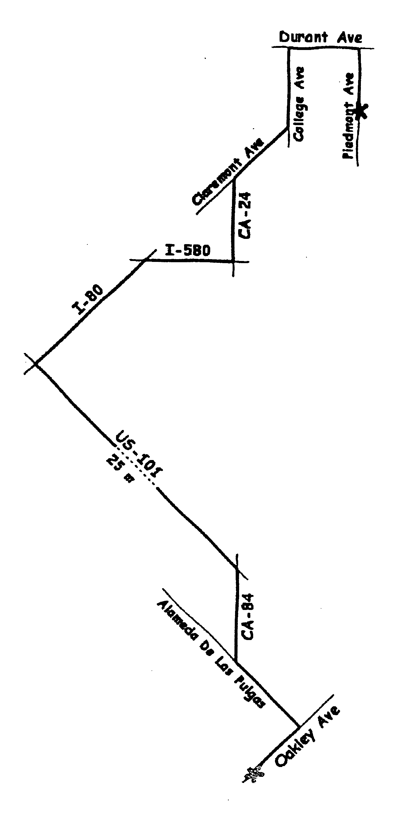
[0085] The present invention provides a system and method for generating maps that have the benefits and characteristics of a hand-drawn map. Automatically generating route maps in this style is complex. Distorting aspects of the map can accentuate reorientation points, but it can also have detrimental effects such as introducing false intersections. Creating an effective route map generally requires searching a large space of possible map layouts for an optimal layout. An efficient multistage algorithm that couples a road layout refinement module with a label and annotation placement module is disclosed. The resulting map is rendered using subtle perceptual cues, such as a wavy hand-drawn style for drawing the paths, to communicate the distortion of scale and shape.

[0086] The design goals of the present invention are:

[0087] (i) Roads should be variably scaled so that all roads and reorientation points are clearly visible and easily labeled.

[0088] (ii) If road A is longer than ro...


PUM


Abstract

A system and method for making computer-generated maps includes a different scale factor for each road in a route. The scale factors are used to optimize the route map against a target function that considers factors such as the number of false intersections in the route and the number of roads falling below a minimum length threshold. A refinement technique such as simulated annealing is used to find a solution to the target function. Each road in the scaled map is rendered to provide a finished product having the appearance of a hand-drawn map. The finished product includes context roads that intersect the main route but are not part of the main route. Furthermore, the hand-drawn map is optimized to the characteristics of the viewport used to visualize the map.

Description

[0001] This application is continuation of U.S. patent application Ser. No. 09 / 727,646 filed Nov. 30, 2000, entitled System And Method For Abstracting And Visualizing A Route Map, which is a continuation-in-part of application Ser. No. 09 / 528,703 filed Mar. 17, 2000, now U.S. Pat. No. 6,424,933, the disclosures of which are hereby incorporated herein by reference in their entirety.[0002] The present invention relates generally to a system and method for generating a route map. More particularly, this invention relates to a system and method for applying a unique scale factor to each road in a route map and for optimizing the positions of labels in the route map. Further, a method for rendering the appearance of roads in the route map is disclosed. BACKGROUND [0003] Route maps, when well designed, are an effective device for visualizing and communicating directions. Such maps have existed in various forms for centuries, and the recent availability of detailed geographic databases via...

Claims


Application Information

Patent Timeline
Patent Type & Authority Applications(United States)
IPC IPC(8): G01C21/36G06T11/20G06T11/60G06T17/05
CPCG01C21/367G01C21/3673G06T17/05G06T11/60G06T11/206
Inventor AGRAWALA, MANEESHSTOLTE, CHRIS
Owner MICROSOFT TECH LICENSING LLC
Why Eureka
Try Eureka