Method and apparatus for displaying a night-view map

a technology of night-view map and display method, which is applied in the direction of maps/plans/charts, navigation instruments, instruments, etc., can solve the problems of limited number of pixels in the horizontal and vertical directions of a display, such as a liquid crystal display, and users cannot clearly recognize the actual situation,

Active Publication Date: 2005-10-13
ALPINE ELECTRONICS INC
View PDF16 Cites 13 Cited by
  • Summary
  • Abstract
  • Description
  • Claims
  • Application Information

AI Technical Summary

Benefits of technology

[0009] Accordingly, it is an object of the present invention to provide an electronic device having a navigation function and a method for displaying buildings, in which the buildings can be displayed properly based on the unit of the bar scale of a map appearing on a display, to solve the problems with the related art described above.
[0013] According to an embodiment of the present invention, building data is decimated based on the unit of the bar scale of a map appearing on a display, so that buildings can be displayed realistically even at a small scale. Moreover, in a nighttime mode, locations of buildings emit light on a night-view map to avoid boredom. Thus, a night-view map that entertains users can be displayed.

Problems solved by technology

However, the number of pixels (resolution) in the horizontal and vertical directions on a display, such as a liquid crystal display, is limited.
When all buildings and the like are displayed in this situation, they are so close to each other that users cannot clearly recognize them.
When no buildings and the like are displayed at a small scale, the screen is feature-less, so that users cannot perceive the actual situation and cannot find the screen appealing.
On the other hand, when picture data is used at a small scale, as disclosed in the foregoing document, high costs are involved in creating, processing, and storing the picture data.

Method used


Image

  • Method and apparatus for displaying a night-view map
  • Method and apparatus for displaying a night-view map
  • Method and apparatus for displaying a night-view map

Examples


Embodiment Construction

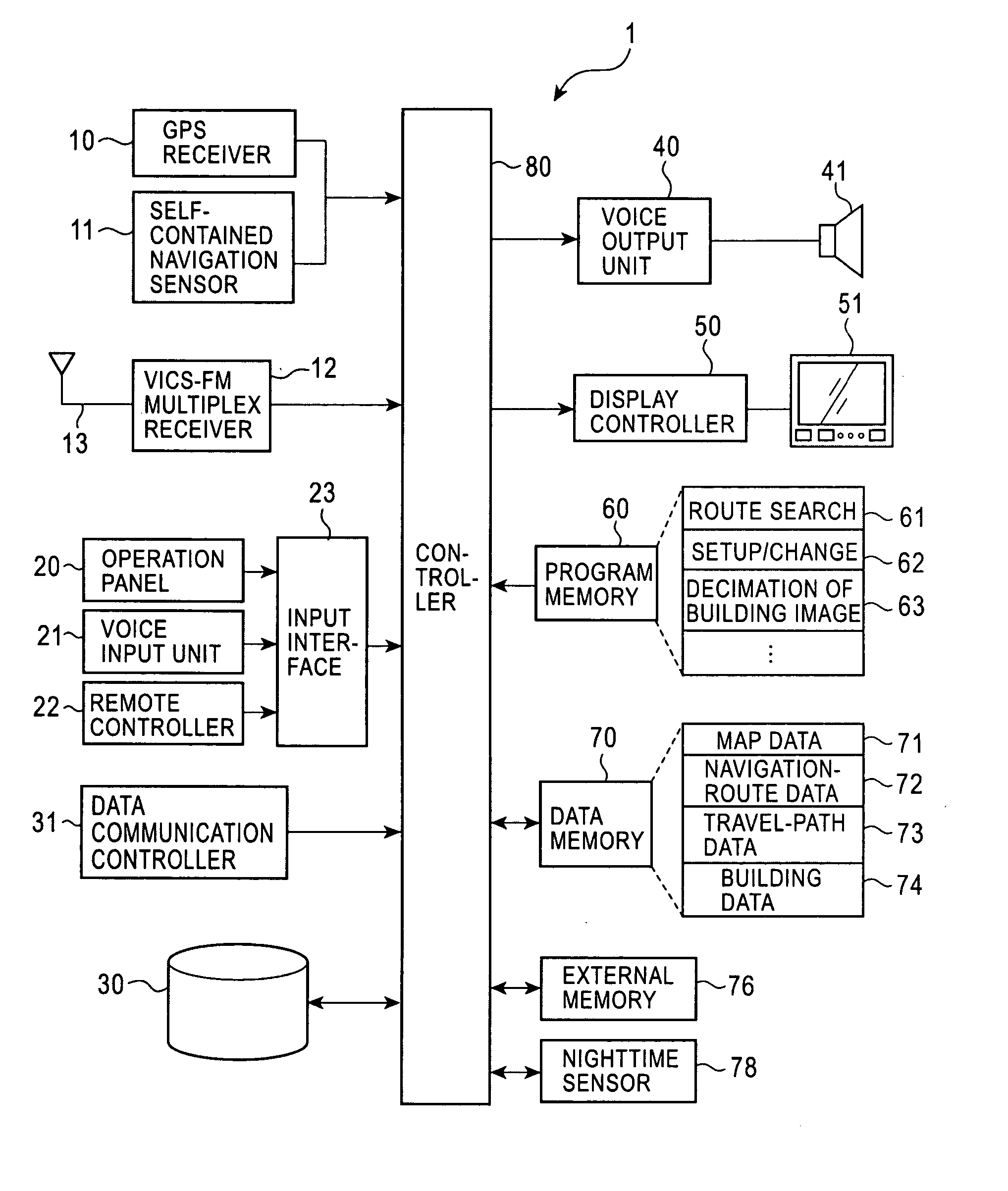
[0026] Embodiments of the present invention are preferably contained in vehicle-mounted navigation apparatuses. The navigation apparatuses will be described in detail with reference to the drawings.

[0027]FIG. 1 is a block diagram illustrating the structure of a navigation apparatus according to an embodiment of the present invention. A global positioning system (GPS) receiver 10 receives electromagnetic waves from a GPS satellite to measure the current position and orientation of a vehicle. A self-contained navigation sensor 11 includes a vehicle speed sensor measuring distance traveled by the vehicle and an angle sensor measuring a rotation angle of the vehicle. Position detection signals are supplied to a controller 80 from both the GPS receiver 10 and the self-contained navigation sensor 11. The controller 80 indicates the current vehicle position on a map based on these position detection signals.

[0028] A vehicle information and communication system-frequency modulation (VICS-...


PUM


Abstract

A navigation apparatus including a memory for storing building data of buildings; a display; a decimating unit for decimating the building data based on the unit of the bar scale of a map appearing on the display; and a display controller for displaying the buildings on a map on the display based on the building data decimated by the decimating unit.

Description

BACKGROUND OF THE INVENTION [0001] 1. Field of the Invention [0002] The present invention relates to electronic devices having navigation functions for searching for routes to a destination and displaying a map around a current vehicle position, and in particular, relates to methods for displaying night-view maps. [0003] 2. Description of the Related Art [0004] A navigation apparatus detects a current vehicle position, reads out data of a map around the current vehicle position from a map database, draws a map on a display, and superimposes a vehicle mark on the map. When the current vehicle position changes in response to movement of the vehicle, the map scrolls and the vehicle mark moves in response to the movement of the vehicle. [0005] A map to be displayed preferably shows images of, for example, actual roads and intersections, as closely as possible and presents the images to users as guidance information in a plain format. Particularly, in displaying, for example, intersectio...

Claims


Application Information

Patent Timeline
Patent Type & Authority Applications(United States)
IPC IPC(8): G09B29/00G01C21/00G01C21/32G08G1/0969G09B29/10
CPCG09B29/106G01C21/32G08G1/0969
Inventor YUASA, MIZUKIKUROSAWA, TAKESHI
Owner ALPINE ELECTRONICS INC
Why Eureka
Try Eureka