Method for positioning using GPS in a restrictive coverage environment

a technology of restrictive coverage and gps, applied in the field of gps receivers operating in restrictive coverage environments, can solve the problem of adversely affecting accuracy by the overall quality of range data

Active Publication Date: 2006-01-19
NOVATEL INC
View PDF7 Cites 17 Cited by
  • Summary
  • Abstract
  • Description
  • Claims
  • Application Information

AI Technical Summary

Benefits of technology

[0009] As long as a given GPS receiver has tracked at least two satellites simultaneously for 3 or 4 relatively short time intervals at different sky locations during the extended period, the batch processing of the range information produces the position of the GPS receiver to within the relatively tight tolerances that are required for applications such as surveying or seismic measuring. The batch processing allows the system to calculate the precise position of the GPS receiver without requiring that the GPS receiver continuously track the GPS satellite signals from multiple satellites and / or track the signals from the same set GPS satellites.

Problems solved by technology

As discussed, the accuracy is adversely affected by the overall quality of the range data.

Method used


Image

  • Method for positioning using GPS in a restrictive coverage environment
  • Method for positioning using GPS in a restrictive coverage environment
  • Method for positioning using GPS in a restrictive coverage environment

Examples


Embodiment Construction

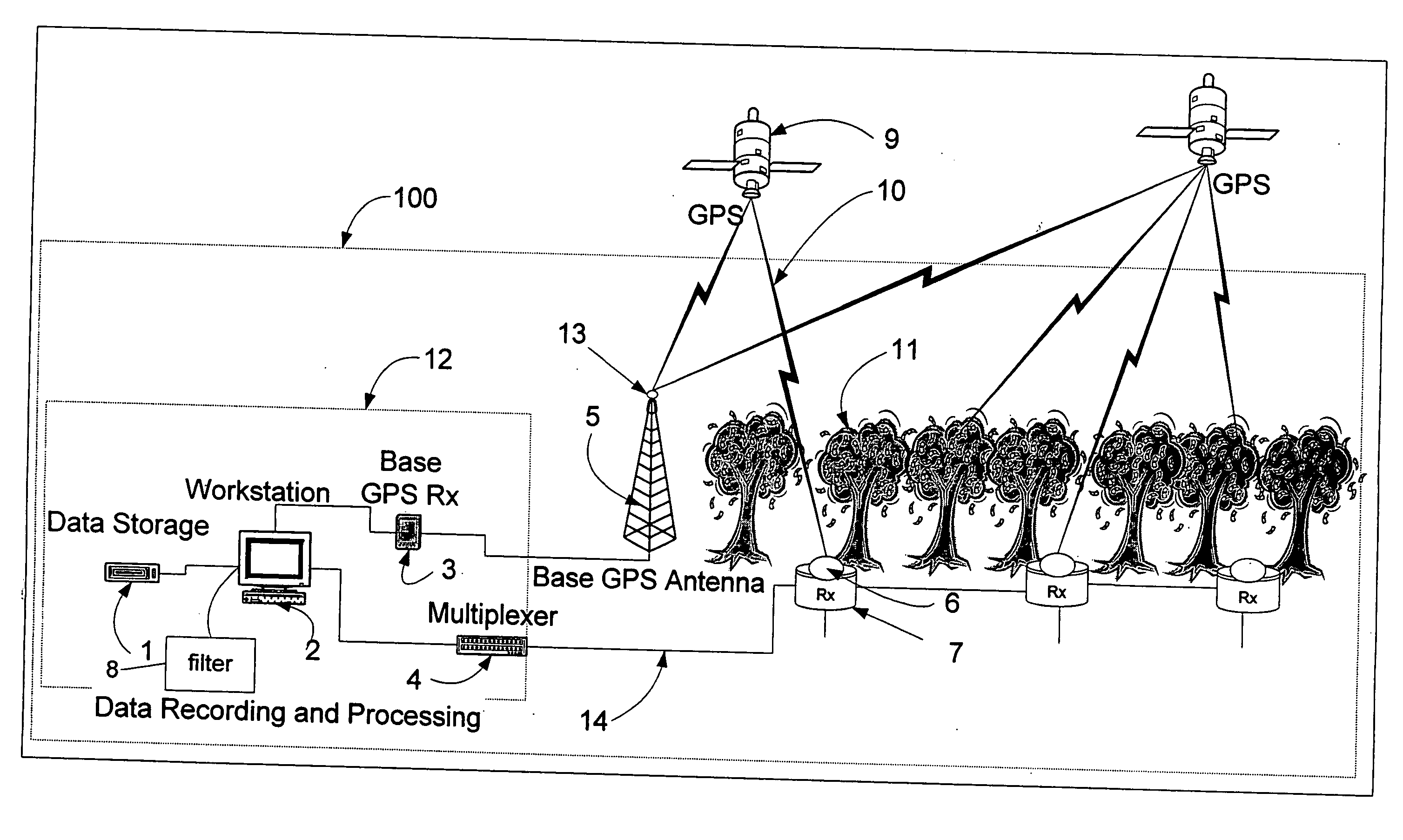
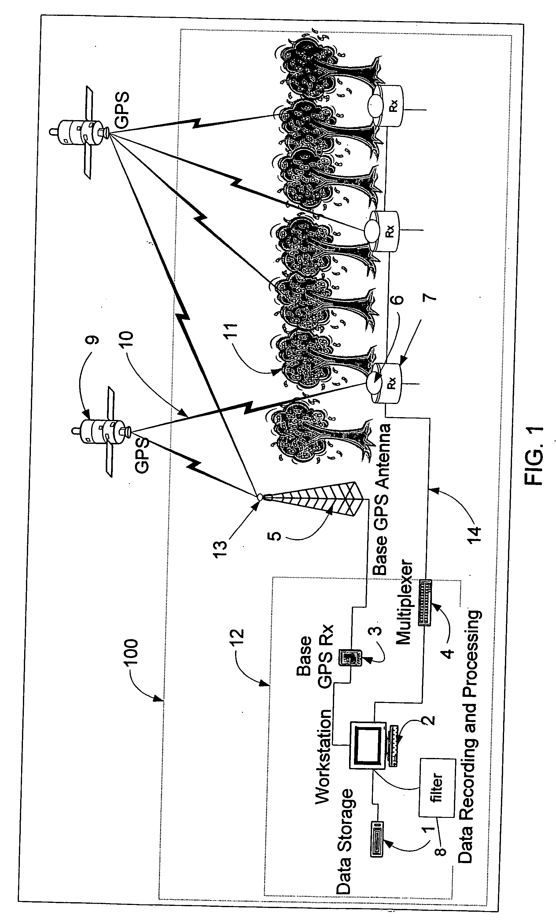
[0018] Referring now to FIG. 1, a positioning system 100 includes a plurality of GPS receivers 6 that supply range information, that is, pseudoranges and carrier measurements, to a data recording and control center 12 through signal receivers 7 that are located in selected locations over a site of interest. The signal receivers 7 are connected to the center by cables 14. The center 12 includes one or more workstations 2 and data storage devices 1 that retain and process the range information. The signals from various cables 14 (only one of which is shown in the drawing) are supplied to the one or more workstations 2 through a multiplexer 4, which operates in a conventional manner. The GPS receivers 6 are sometimes referred to herein as “remote receivers.”

[0019] The data recording and control center 12 further includes a base GPS receiver 3 that receives signals from various GPS satellites 9 using a base GPS antenna 13, which is positioned to have a clear view of the sky. An elevated...


PUM


Abstract

A system consisting of a base GPS receiver with a clear view of the sky, one or more remote GPS receivers with restricted views of the sky and a processing center that batch processes range information provided by the GPS receivers determines the positions of the remote GPS receivers to within tight tolerances. The base GPS receiver and the remote GPS receivers produce range information based on the satellite signals that the respective receivers can track at a given time, and provide the range information to the processing center. The range information includes both code and carrier measurements for each of the signals that are being tracked by the respective GPS receivers. The center collects the range information over an extended period of time, for example, hours, days or weeks, and then batch processes the collected information in multiple passes through the data, to calculate the precise latitude, longitude and height of the receiver. The center batch processes the data using a floating ambiguity filter that, after a first pass through the data, is initialized with the position calculated in an earlier pass. The center also calculates the quality of the collected range information by fixing the position and position covariance of the floating ambiguity filter and using double differences with the base GPS receiver measurements, to ensure that the information used in subsequent position calculations is sufficiently reliable.

Description

CROSS-REFERENCE TO RELATED APPLICATIONS [0001] The present application claims the benefit of U.S. Provisional Patent Application Ser. No. 60 / 588,099, which was filed on Jul. 15, 2004, by Thomas J. Ford, et al. for a METHOD FOR POSITIONING USING GPS IN A RESTRICTIVE COVERAGE ENVIRONMENT and is hereby incorporated by reference.BACKGROUND OF THE INVENTION [0002] 1. Field of the Invention [0003] The invention relates generally to GPS receivers, and in particular, to GPS receivers operating in restrictive coverage environments. [0004] 2. Background Information BACKGROUND [0005] Surveying or other measurement systems that use fixed-position GPS receivers for precise position information are hindered and, in some cases, prevented from operating in “restrictive coverage” environments. Restrictive coverage environments are those in which direct GPS satellite signals are corrupted by indirect signals (multipath) and, in some cases, particular direct signals are entirely blocked. An example of...

Claims


Application Information

Patent Timeline
Patent Type & Authority Applications(United States)
IPC IPC(8): G01S5/14G01S19/21G01S19/26G01S19/44
CPCG01S19/44G01S5/0036
Inventor FORD, THOMAS J.KENNEDY, SANDY
Owner NOVATEL INC
Why Eureka
Try Eureka