Real-time geographic information system and method

a geographic information system and real-time technology, applied in the field of geographic information systems, can solve the problems of not being able to form a basis for video, suffering from a number of severe limitations, and not being able to provide an extensive set of pre-calibrated reference images covering the site from many different viewing angles

Inactive Publication Date: 2007-02-01
RAFAEL ADVANCED DEFENSE SYSTEMS
View PDF20 Cites 202 Cited by
  • Summary
  • Abstract
  • Description
  • Claims
  • Application Information

AI Technical Summary

Benefits of technology

[0013] According to a further feature of the present invention, the display device is a see-through display device,

Problems solved by technology

Although the Archeoguide system potentially offers a significant step towards a useful outdoor geographic information system, it suffers from a number of severe limitations.
Firstly, the need to provide an extensive set of pre-calibrated reference images covering the site from many different viewing angles is very limiting.
While such an approach may be feasible for highly localized applications such as cultural heritage sites, it cannot form a basis for vide area systems where the task of setting up a large nu

Method used


Image

  • Real-time geographic information system and method
  • Real-time geographic information system and method
  • Real-time geographic information system and method

Examples


Embodiment Construction

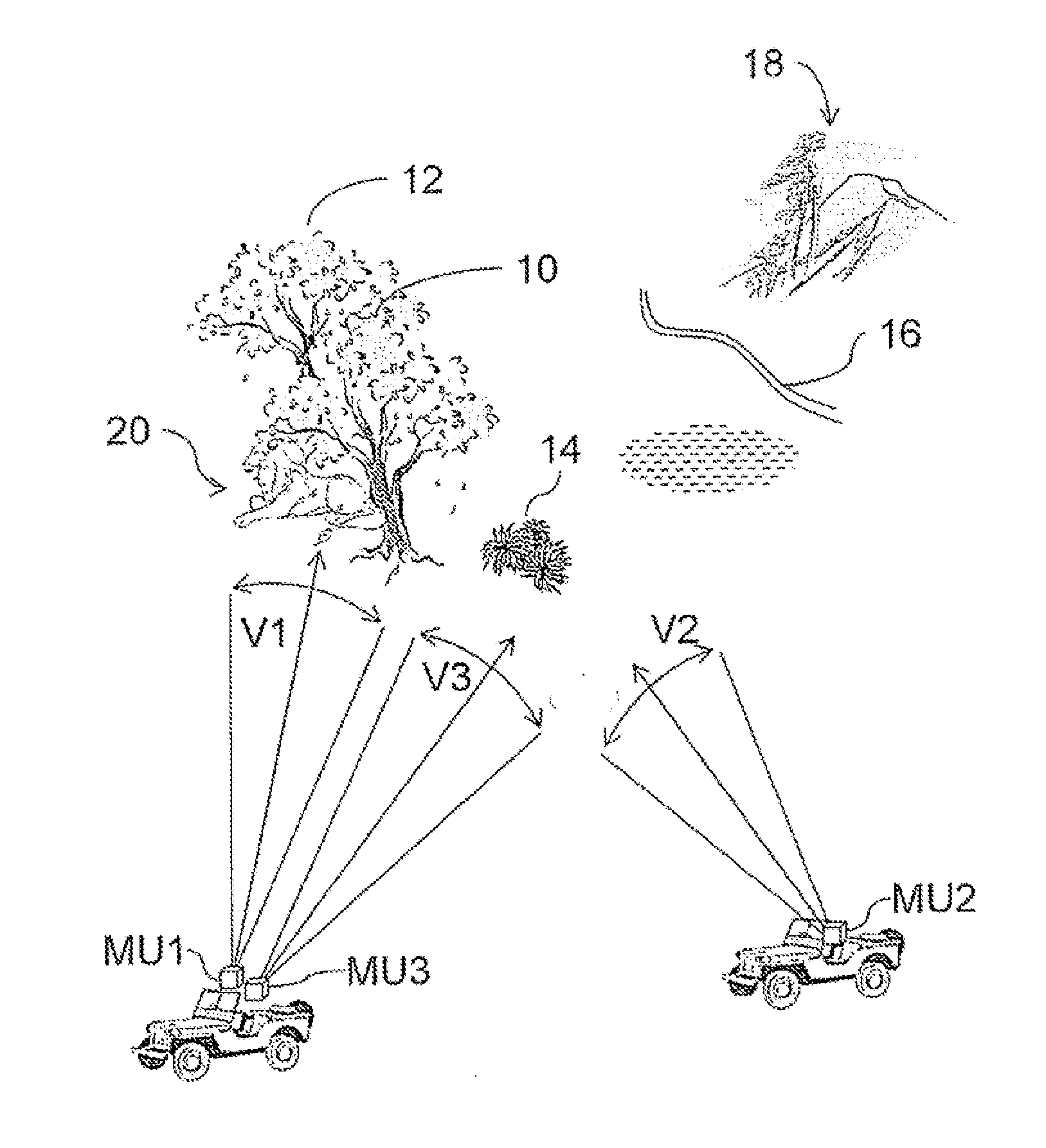
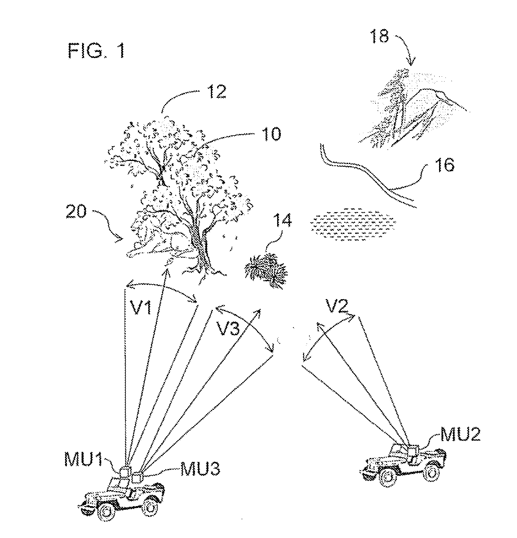
[0062] The present invention is a system and method for dynamic distribution of location-related information between users with different perspective views, and for providing location-related information based on a wide-area geographical database.

[0063] The principles and operation of systems and methods according to the present invention may be better understood with reference to the drawings and the accompanying description.

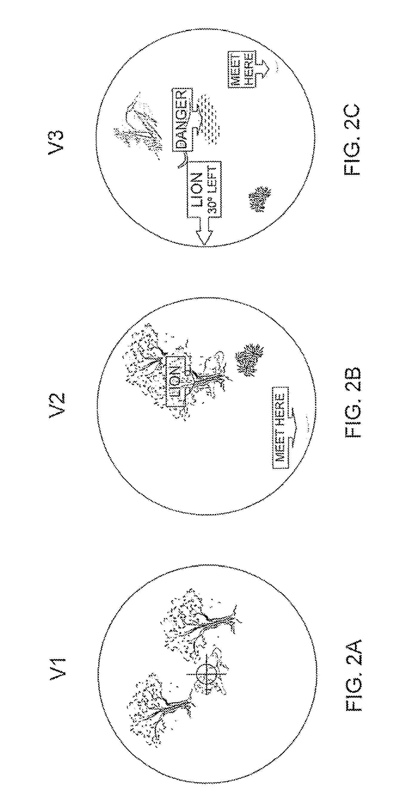
[0064] By way of introduction, the present invention has two distinct aspects which will be described herein, each of which is believed to be patentable in its own right, and which may be used together to particular advantage. According to a first aspect of the invention, a user with a first perspective view can designate a point of interest within his perspective view which will then be displayed correctly positioned in the context of a different perspective view of a second user. This allows dynamic transfer of information between users for updating existin...


PUM


Abstract

An information system for dynamic distribution of location-related information between users with different perspective views includes a number of user units each including a viewing arrangement defining a viewing direction and a registration subsystem for deriving a mapping between the current perspective view and a shared location reference. The user units also include a data management system and a wireless communication arrangement. At least one of the user units further includes a user input interface for designating a viewed location within the current perspective view for association with location-related information to generate a new location-related information entry for sharing with others of the plurality of user units. At least one other of the user units further includes a display device associated with the viewing arrangement for displaying location-related information correctly positioned in the context of the current perspective view.

Description

FIELD AND BACKGROUND OF THE INVENTION [0001] The present invention relates to geographic information system and, in particular, it concerns a system and method for dynamic distribution of location-related information between users with different perspective views, and for providing location-related information based on a wide-area geographical database. [0002] The developing field of technology known as “augmented reality” relates to systems which supplement a view of the real world with additional visual information. This technology has potential applications in a wide range of contexts, for example, ranging from industrial production to tourist information systems and to games. Of particular relevance to the present invention is the context of information systems where a system provides a user with geographic information related to various objects or locations which he or she is viewing. [0003] One example of an augmented reality information system is prototype system under develo...

Claims


Application Information

Patent Timeline
IPC IPC(8): G05D1/00
CPCG06F17/3087G06F16/9537
Inventor GOLDENBERG, SHARONSOLOMON, OFERSROKA, IGALZILBERSTEIN, OFERDIVR, MENACHEM
Owner RAFAEL ADVANCED DEFENSE SYSTEMS
Why Eureka
Try Eureka