Route condition evaluation method and apparatus for navigation system

a condition evaluation and navigation system technology, applied in surveying, navigation, instruments, etc., can solve the problems of high cost associated with the route, etc., to reduce the cost, increase the cost, and modify the cost

Active Publication Date: 2008-02-14
ALPINE ELECTRONICS INC
View PDF3 Cites 74 Cited by
  • Summary
  • Abstract
  • Description
  • Claims
  • Application Information

AI Technical Summary

Benefits of technology

[0012]It is, therefore, an object of the present invention to provide a method and apparatus for a navigation system which is capable of evaluating a route condition for determining an optimum route to the destination.
[0016]When the conflicting situation is caused because one candidate route shows traffic speed information while another candidate route lacks traffic speed information, a traffic speed for the another candidate route is created by decreasing a maximum allowable speed of the another candidate route by a predetermined ratio, thereby increasing the cost. Alternatively, when the conflicting situation is caused because one candidate route shows traffic speed information while another candidate route lacks traffic speed information, a traffic speed for the one candidate route is increased by a predetermined ratio, thereby decreasing the cost.
[0018]According to the present invention, the route condition evaluation method and apparatus incorporates a cost associated with the traffic information in addition to the traditional cost associated with the map data. An optimum route to the destination is determined by comparing the costs of two or more candidate routes and selecting a candidate route of the least cost. The method and apparatus is able to adjust the cost of a candidate route based on the relevancy and reliability of the traffic information. Since the relevancy and reliability of the traffic information are taken into account, it is possible to determine an optimum route to a destination more accurately.

Problems solved by technology

In a case where a distance for a particular route is long, the cost associated with the route is deemed high.
Even a distance is short, if it takes a long time to pass through a particular route, the cost associated with the route is deemed high.
If a particular route includes a toll road, the cost associated with the route is deemed high.
When the existence of a traffic incident is indicated in a particular road, the cost for the road is high.
However, when there are conflicting information for such a road, how to weigh the cost in calculating the route is problematic.
Thus, there is a conflict as to which information represent the actual road condition and how to weigh the information for calculating the cost.
The traffic speed on Freeway 52 is therefore unknown, and thus, how the cost associated with the route involving Freeway 52 and Freeway 8 is problematic in finding an optimum route.

Method used


Image

  • Route condition evaluation method and apparatus for navigation system
  • Route condition evaluation method and apparatus for navigation system
  • Route condition evaluation method and apparatus for navigation system

Examples


Embodiment Construction

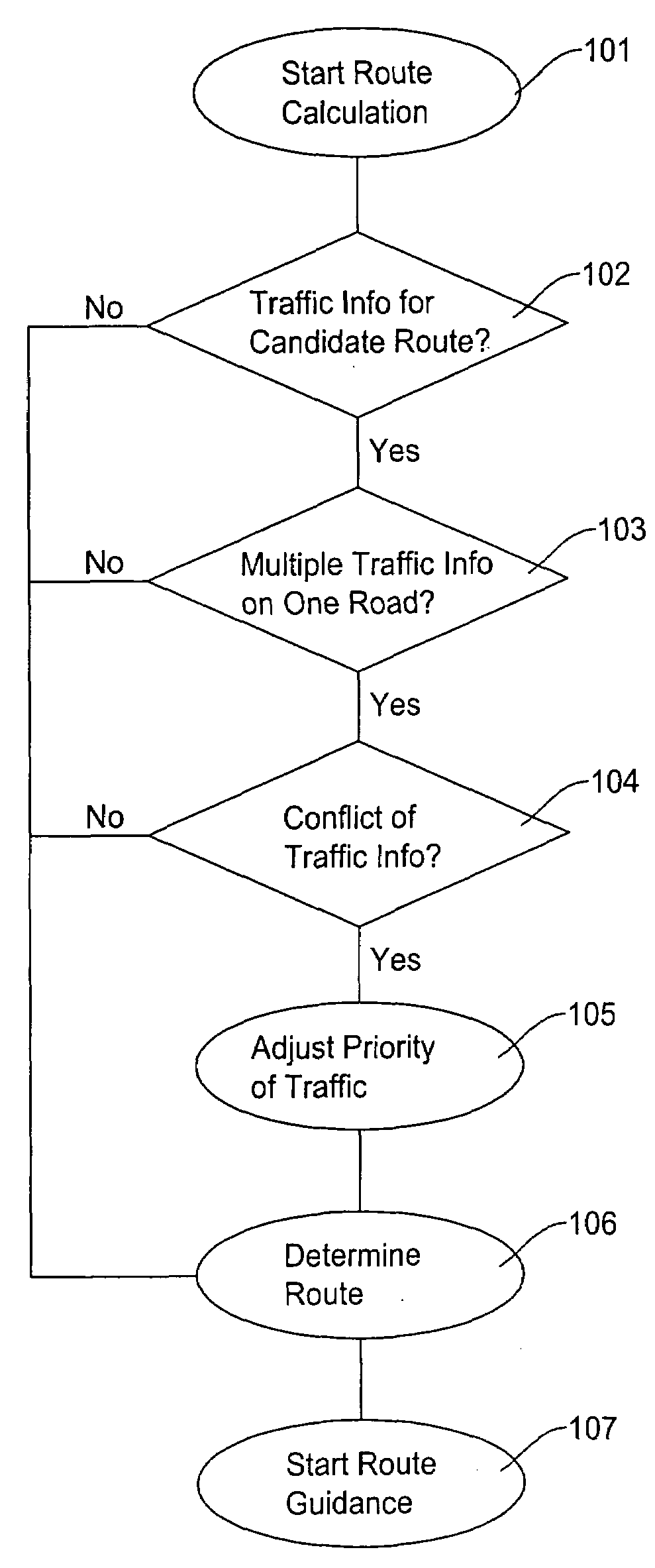
[0029]The present invention will be described in detail with reference to the accompanying drawings. The route condition evaluation method and apparatus for a navigation system in the present invention is able to adjust the cost associated with candidate routes to the destination. Especially, the route condition evaluation method and apparatus weighs and prioritizes the traffic information when there is conflicting information or lack of certain information on road conditions to improve accuracy of selecting an optimum route.

[0030]In determining an optimum route to the destination, the route search method and apparatus evaluates the traffic information in addition to the traditional route information obtained from the map data. Some of the recent navigation systems are equipped with an apparatus that can receive traffic information such as traffic incidents and road conditions. The traffic incidents include a traffic accident, stalled vehicle, police inspection, fire, and the like. ...


PUM


Abstract

A method and apparatus for a navigation system evaluates an overall cost of each candidate route by incorporating traffic information such as traffic incident types and traffic flow speeds. An optimum route to the destination is determined by comparing the costs of two or more candidate routes and selecting a candidate route of the least cost. The method and apparatus determines relevancy and accuracy of the traffic information and adjusting the cost of the candidate route. When the traffic information on the candidate route shows a conflicting situation, the method and apparatus modifies the cost derived from the traffic information. When modifying the cost, the traffic speed information is prioritized over other type of traffic information.

Description

FIELD OF THE INVENTION[0001]This invention relates to a route condition evaluation method and apparatus for a navigation system, and more particularly, to a route condition evaluation method and apparatus for a navigation system that is capable of determining an optimum route to a destination by evaluating overall costs involved in candidate routes based on types of available traffic information in addition to traditional route information available from map data.BACKGROUND OF THE INVENTION[0002]A navigation system performs travel guidance for enabling a user to easily and quickly reach the selected destination. A typical example is a vehicle navigation system where a navigation function is provided in a vehicle. Such a navigation system detects the position of the user, and reads out map data pertaining to an area at the current position of the user from a data storage medium, for example, a CD-ROM (compact disc read-only memory), a DVD (digital versatile disc), or a hard disc. Alt...

Claims


Application Information

Patent Timeline
Patent Type & Authority Applications(United States)
IPC IPC(8): G01C21/00
CPCG01C21/3492G08G1/096775G08G1/09675G08G1/096716
Inventor TU, IHUNG
Owner ALPINE ELECTRONICS INC
Why Eureka
Try Eureka