GPS accuracy adjustment to mitigate multipath problems for MEMS based integrated INS/GPS navigation systems

Active Publication Date: 2008-04-17
ALPINE ELECTRONICS INC
View PDF6 Cites 41 Cited by
  • Summary
  • Abstract
  • Description
  • Claims
  • Application Information

AI Technical Summary

Benefits of technology

[0013]According to the present invention, even when the GPS measurement values are deviated from that expected, the INS/GPS navigation system of the present invention uses as many measurement outliers as possible without discarding, unless they are obvious error values. Typically, measurement outliers occur when the integrated INS/GPS navigation system receives GPS signals which have transmitted through multipaths, i.e., reflection by buildings, since the signal path lengths var

Problems solved by technology

However, the INS cannot provide high accuracy at long ranges.
Particularly, inertial sensors are subject to errors that tend to accumulate over time, i.e., the longer the drive time, the greater the inaccuracy.
However, since the GPS relies on GPS satellites, it is susceptible to jamming, RF (radio frequency) interference and multipath problems.
Although the GPS provides accurate position and velocity over longer time periods, the GPS involves occasional large multipath errors and signal dropouts.
Inertial sensors used to be expensive and bulky only used in

Method used


Image

  • GPS accuracy adjustment to mitigate multipath problems for MEMS based integrated INS/GPS navigation systems
  • GPS accuracy adjustment to mitigate multipath problems for MEMS based integrated INS/GPS navigation systems
  • GPS accuracy adjustment to mitigate multipath problems for MEMS based integrated INS/GPS navigation systems

Examples


Embodiment Construction

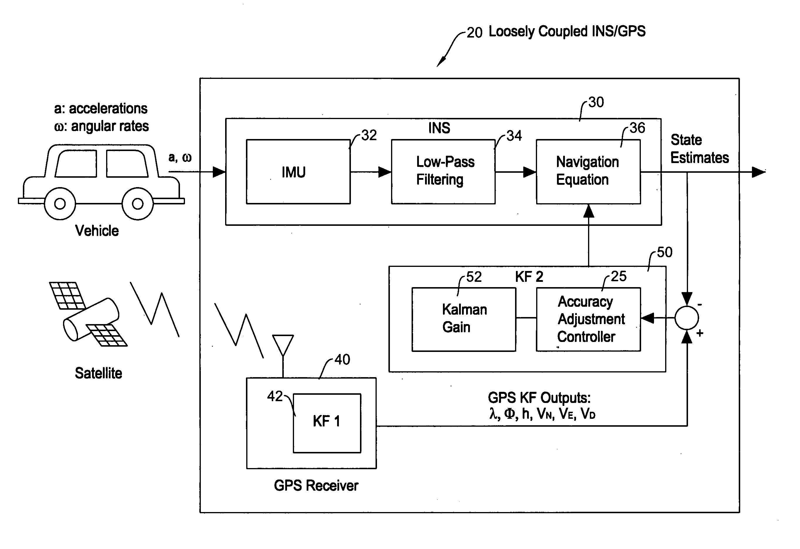
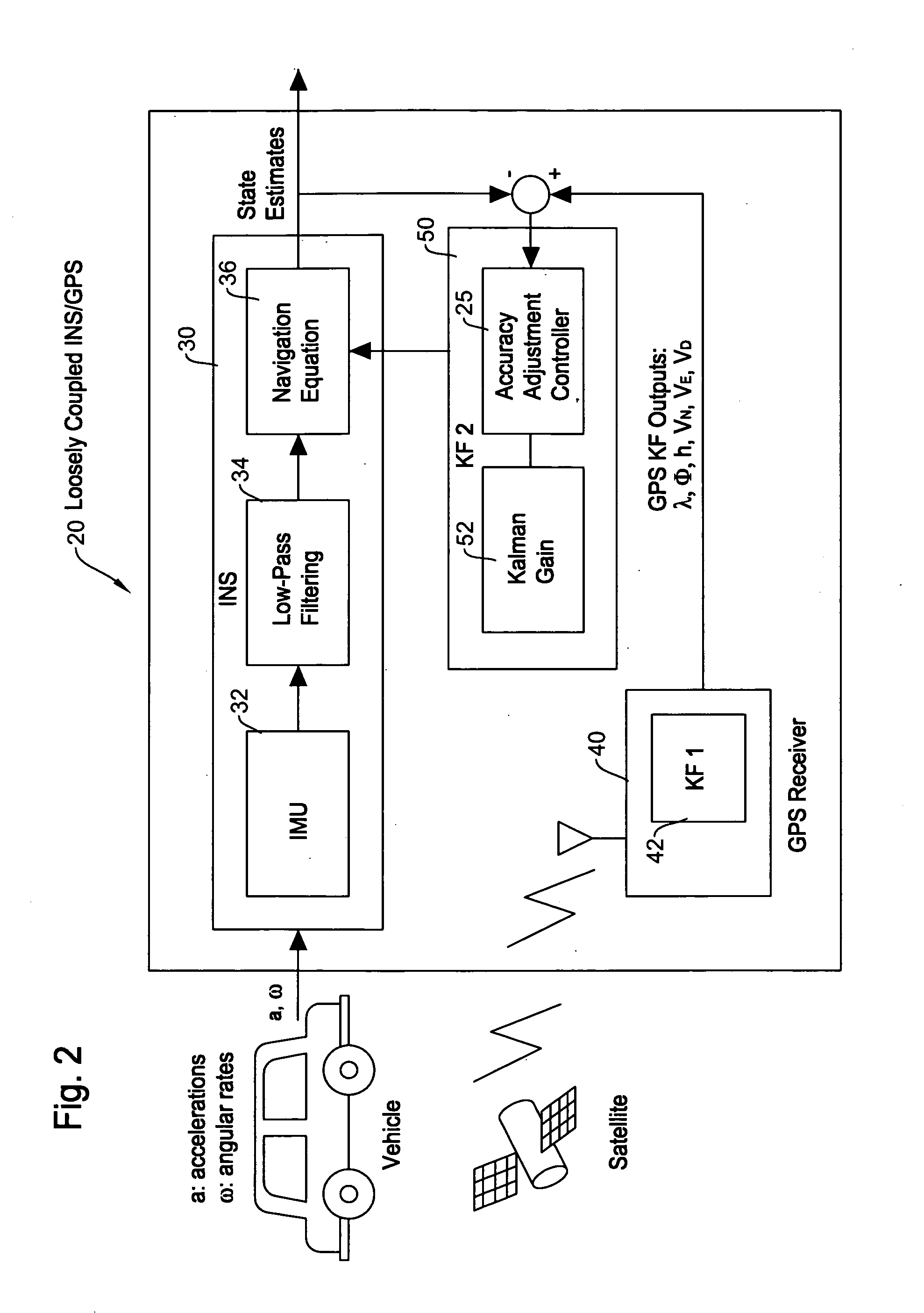
[0023]The present invention will be described in detail with reference to the accompanying drawings. The method of the present invention does not rigorously detect multipath problems. Using the number of visible GPS satellites, the method assumes certain periods when multipath problems may happen. During the periods, measurement outlier's accuracy is intentionally lowered so that it does not adversely influence the INS performance, but utilizing all the measurements. The important philosophy here is to use as many measurements as possible without discarding, unless they are obvious error values.

[0024]Here, a “measurement outlier” means a parameter in the GPS measurement output whose difference from the corresponding a Kalman filter estimate overly exceeds theoretical residual σ value expected by the Kalman filter (integration Kalman filter) in an integrated INS / GPS navigation system. Typically, a measurement outlier occurs when an integrated INS / GPS navigation system receives GPS si...


PUM


Abstract

A method of GPS accuracy adjustment for an integrated INS/GPS navigation system which utilizes microelectro mechanical systems (MEMS) based inertial sensors to mitigate multipath problems arising when a vehicle is in an area with many high-rise buildings is disclosed. Even when GPS measurement output values are deviated from that expected, the INS/GPS navigation system uses as many measurement outliers as possible without discarding, unless they are obvious error values. The measurement outliers occur when the integrated INS/GPS navigation system receives GPS signals which have transmitted through multipaths such as reflection by buildings, since the signal path lengths vary. Even in such a condition, rather than simply discarding such measurement outliers, the method utilizes the measurement outliers while adjusting the accuracy thereof depending on the degree of deviation. Since the integrated INS/GPS navigation system is able to utilize both the INS output and the GPS measurement, it is possible to maintain a practical level of accuracy in the position tracking when a vehicle is in an area of tall buildings.

Description

FIELD OF THE INVENTION[0001]This invention relates to a method involving a vehicle navigation system, and more particularly, to a GPS accuracy adjustment method for an integrated INS / GPS navigation system which utilizes MEMS based inertial sensors for mitigating multipath problems arising when a vehicle is in an area with many high-rise buildings.BACKGROUND OF THE INVENTION[0002]An inertial navigation system (INS) is a widely used technology for guidance and navigation of a vehicle. The INS is composed of an inertial measurement unit (IMU) and a processor where an IMU houses accelerometers and gyroscopes which are inertial sensors detecting platform motion with respect to an inertial coordinate system. An important advantage of the INS is independence from external support, i.e., it is self-contained. However, the INS cannot provide high accuracy at long ranges. Particularly, inertial sensors are subject to errors that tend to accumulate over time, i.e., the longer the drive time, t...

Claims


Application Information

Patent Timeline
IPC IPC(8): G01C21/00G01S19/26
CPCG01S19/47G01C21/165
Inventor HOSHIZAKI, TAKAYUKI
Owner ALPINE ELECTRONICS INC
Why Eureka
Try Eureka