Delivery map creation method and device and differential data creation method and device

a map and creation method technology, applied in surveying and navigation, navigation instruments, instruments, etc., can solve the problems of not revealing how the map data is specifically updated with the use of commonalities, complex control, obsolete map data stored in recording media over time,

Inactive Publication Date: 2009-01-01
ALPINE ELECTRONICS INC
View PDF9 Cites 17 Cited by
  • Summary
  • Abstract
  • Description
  • Claims
  • Application Information

AI Technical Summary

Benefits of technology

[0043]According to an aspect of the present invention, the area including the new road may be displayed on the display screen by using the new map data, and the predetermined links may be specified on the display screen, to thereby set the boundary links of the new map. Further, the area may be displayed on the display screen with the use of the old map data, and the predetermined links may be specified on the display screen, to thereby set the boundary links of the old map. Accordingly, the boundary links can be easily set. In this case, if the area of the new map and the area of the old map are displayed in juxtaposition on the display screen using the new map data and the old map data, respectively, to set the boundary links, the matching between the boundary links of the new map and the boundary links of the old map can be easily performed.
[0044]According to an aspect of the present invention, it is possible to search for all routes leading from each of the boundary links of the new map to the other boundary links by using the new map data, and to automatically search for the new road constituent links by extracting the new road constituent links from the links constituting the respective routes without causing overlapping of the extracted links. Further, according to an aspect of the present invention, it is possible to search for all routes leading from each of the boundary links of the old map to the other boundary links by using the old map data, and to automatically search for the deletion links by extracting the deletion links from the links constituting the respective routes without causing overlapping of the extracted links.
[0045]According to an aspect of the present invention, based on the nodes at the opposite ends of the boundary links, the nodes on the side of the new road constituent links may be identified in the setting of the boundary links. Therefore, the new road constituent links can be reliably searched for. Further, according to an aspect of the present invention, based on the nodes at the opposite ends of the boundary links, the nodes on the side of the deletion links may be identified. Therefore, the deletion links can be reliably searched for.

Problems solved by technology

The map data stored in the recording medium becomes obsolete over time due to a change in terrain data caused by the construction of a new road or the like, the opening or closing of a facility, the housing land development, and other reasons.
Therefore, the control is complicated.
The second conventional technique, however, does not disclose how the map data is specifically updated with the use of the commonalities and differences.
Further, due to a large number of the differential data files, the reproduction of a music CD, a DVD video, or the like is interrupted for a long time.

Method used


Image

  • Delivery map creation method and device and differential data creation method and device
  • Delivery map creation method and device and differential data creation method and device
  • Delivery map creation method and device and differential data creation method and device

Examples


Embodiment Construction

[0066](A) Overview of Creation of Delivery Map:

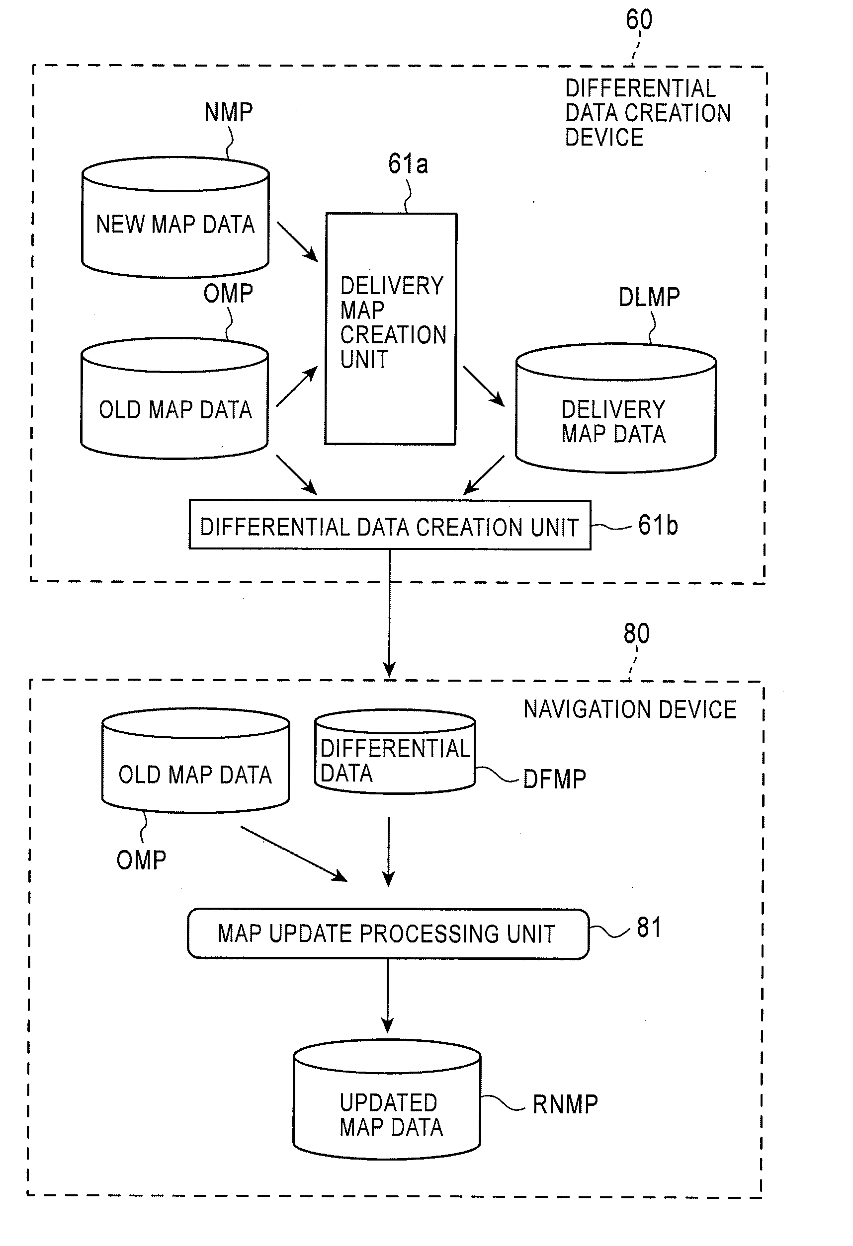
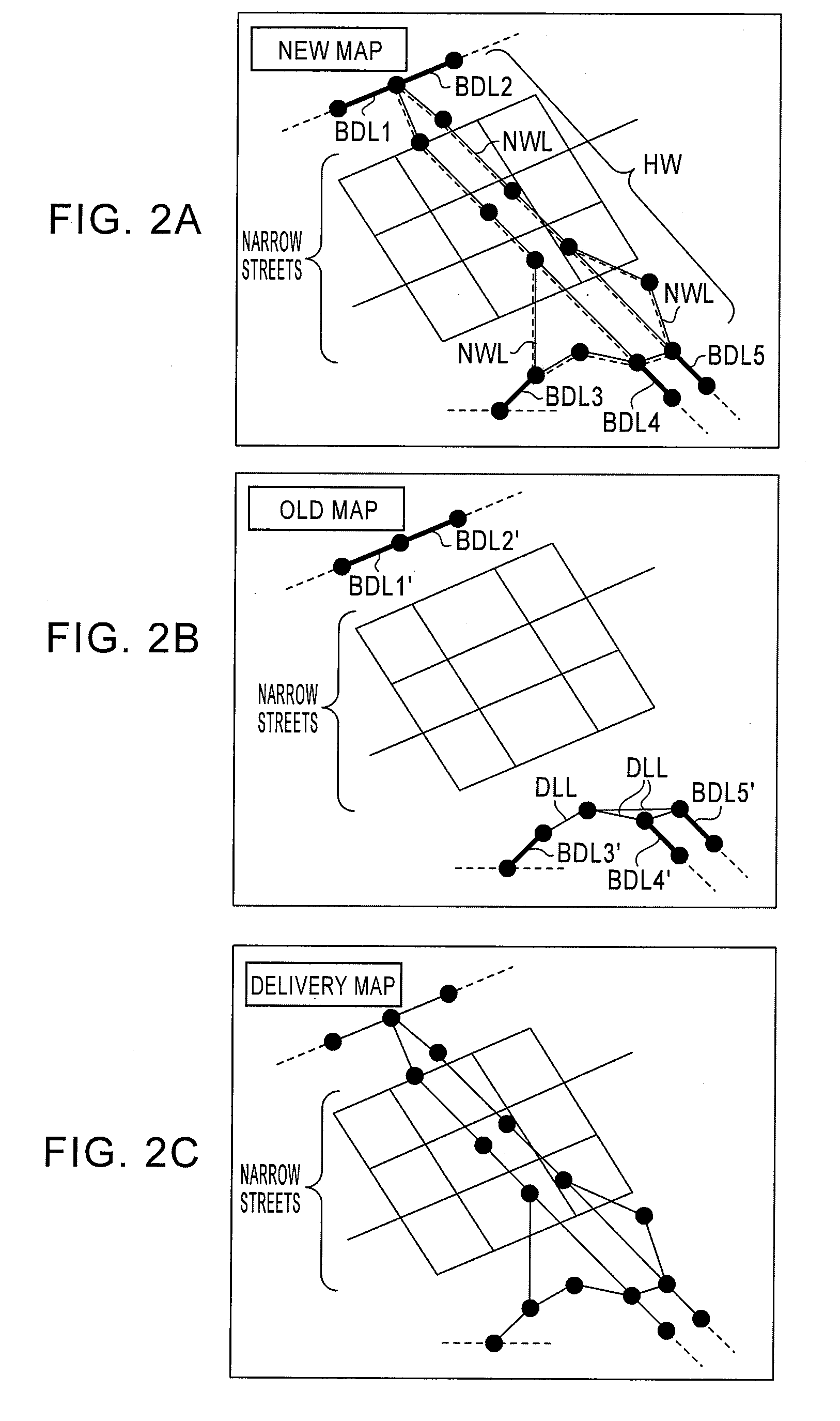
[0067]FIG. 1 is a configuration diagram of a map updating system for updating old map data. The map updating system is constituted by a differential data creation device 60 and a navigation device 80. FIGS. 2A to 2C are diagrams for explaining a delivery map creation process. FIG. 2A illustrates a display example in which a road link connection diagram (a road network) of an area, including a newly opened route HW, is generated with the use of new map data and displayed on a monitor. FIG. 2B illustrates a display example in which another road link connection diagram of the area is generated with the use of old map data and is displayed on the monitor. FIG. 2C illustrates a display example in which another road link connection diagram of the area is generated with the use of delivery map data and is displayed on the monitor. In FIG. 2A, links NWL indicated by broken lines constitute new road constituent links constituting the newly opene...


PUM


Abstract

In a new map, links not constituting a new road and connected to links constituting the new road, are set as boundary links. Further, in an old map, the same links as the boundary links of the new map are set as boundary links of the old map. Then, in the new map, links connecting between the boundary links are searched for as new road constituent links. Further, in the old map, links connecting between the boundary links are searched for as deletion links. Then, link information of the respective boundary links of the old map data is replaced with link information of the respective boundary links of the corresponding new map data. The link information of the deletion links is then deleted from the old map data, and link information of the new road constituent links is added to the old map data, to thereby create delivery map data.

Description

PRIORITY CLAIM [0001]This application claims the benefit of Japanese Patent Application No.: 2007-167110, which was filed on Jun. 26, 2007, and which is incorporated by reference herein in its entirety.BACKGROUND OF THE INVENTION[0002]1. Field of the Invention[0003]The present invention relates to a delivery map creation method and device and a differential data creation method and device, and particularly to a delivery map creation method for creating delivery map data by adding link information relating to a predetermined new road included in new map data to old map data. A differential data creation method for creating differential data is used to update the old map data to the new map data by using the delivery map data.[0004]2. Description of the Related Art[0005]A navigation device reads map data according to a current location of a vehicle from a recording medium, such as a CD-ROM (Compact Disk-Read Only Memory), a DVD (Digital Versatile Disk), and an HDD (Hard Disk Drive), t...

Claims


Application Information

Patent Timeline
Patent Type & Authority Applications(United States)
IPC IPC(8): G01C21/32
CPCG01C21/32G01C21/3859G01C21/3815
Inventor OTSUKI, KOHEI
Owner ALPINE ELECTRONICS INC
Why Eureka
Try Eureka