Method and system for dynamic, three-dimensional geological interpretation and modeling

a three-dimensional geological interpretation and modeling technology, applied in seismology for waterlogging, instruments, reradiation, etc., can solve the problems of inability to render real-time, inability to solve correlation and mapping problems in a two-dimensional environment, stagnation in functional development of these applications, etc., to save significant amounts of time and resources, improve correlation workflow, and reduce the amount of time spent on generating structural surfaces

Active Publication Date: 2009-02-12
AUSTIN GEOMODELING
View PDF6 Cites 84 Cited by
  • Summary
  • Abstract
  • Description
  • Claims
  • Application Information

AI Technical Summary

Benefits of technology

[0017]Techniques here disclosed include a geological interpretation method and system replaces that replaces known two-dimensional process with an integrated, three-dimensional geological interpretation environment. The disclosed subject matter combines seismic and well-log data into an interactive three-dimensional geological interpretation environment. The disclosed geological interpretation system focuses on interpretation speed, ease of use, and improved accuracy. In essence, the presently disclosed subject matter allows a user to perform geology on a computer workstation to a degree not previously possible.
[0018]According to one aspect of the disclosed subject matter, there is provided a method and system for performing geological interpretation operations in support of energy resources exploration and production. The disclosed method and system perform well log correlation operations for generating a set of graphical data that describes the predetermined geological region. The process and system interpret the geological environment of the predetermined geological region from measured surface and fault data associated with the predetermined geological region. The method and system allow the user to query and filter graphical data representing the predetermined geological region, the method and system present manipulable three-dimensional geological interpretations of two-dimensional geological data relating to the predetermined geological region and provide displays of base map features associated with the predetermined geological region. The method and system automatically update the manipulable three-dimensional geological interpretations of two-dimensional data relating to the predetermined geological region, as well as create three-dimensional well log and seismic interpretations of geological data relating to the predetermined geological region. Moreover, time-related visualizations of production volumes relating to the predetermined geological region are provided for enhancing the ability to interpret and model various geological properties of various geological regions.

Problems solved by technology

The drawback of such tools includes that they solve correlation and mapping problems in a two-dimensional environment, merely replacing the paper workflows with computer screens without truly speeding the geological interpretation process.
Current three-dimensional modeling applications are not capable of rendering real-time results, because they do not work practically as geological interpretation tools.
The functional development of these applications has stagnated in recent years, despite costing oil and gas companies millions of dollars in maintenance and deployment costs.
Today, market-leading products are not easily portable or scalable.
Instead of creating an environment of continuous innovation, no known solutions enable oil and gas companies to optimize their workflows through timesavings or the use of new features.
The known systems require expensive and complicated software maintenance and support, essentially due to their lack of integration between the ever-growing lists of PC or smaller applications.
One key limitation of known systems supporting geological interpretation, derives from the use of centralized databases.
One of the drawbacks of centralized database systems is an inflexibility regarding the quick integration of certain geological data types.
As a result, exclusion of important data occurs due to a lack of time.
Another limitation of known systems and process for geological interpretation is that well plans created using static geological interpretation and modeling tools rarely match the real world geology encountered during drilling.
Conventional well planning solutions spread the interpretation while drilling (IWD) workflows across multiple applications and data management modules, making it difficult and time consuming for energy resource exploration and production teams to integrate new data in order to reconstruct the geological interpretation.
However, for those who are trying to compete using paper-based interpretation workflows, the development of a robust interpretation is a slow and tedious process.
Furthermore, with each new data point, updating paper cross-sections and maps is frustratingly slow and cumbersome.
Valuable time is therefore lost throughout the entire process, from data collection to the delivery of a finalized prospect.
This process may take from hours to days to complete, and is tediously repetitive, costing valuable time and resources before finalizing an interpretation.

Method used


Image

  • Method and system for dynamic, three-dimensional geological interpretation and modeling
  • Method and system for dynamic, three-dimensional geological interpretation and modeling
  • Method and system for dynamic, three-dimensional geological interpretation and modeling

Examples


Embodiment Construction

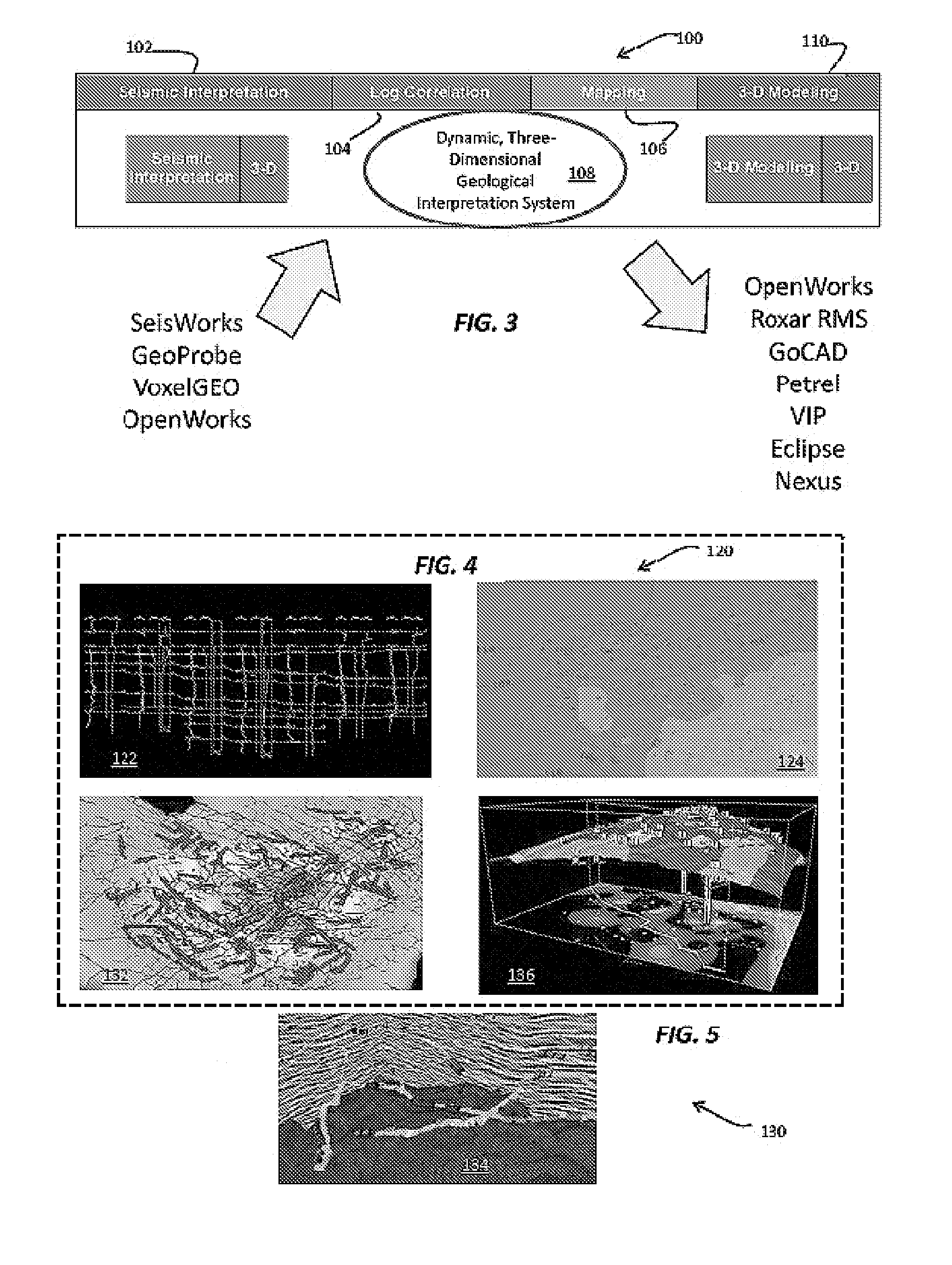
[0067]The disclosed geological interpretation system delivers three-dimensional geological interpretation performance with true three-dimensional subsurface solutions, fast interpretation updates, and integration with the Landmark Graphics OpenWorks® and SeisWorks® systems. The effect on user workflow speed and approach is dramatic and translates into higher quality interpretations, lower risk, and improved success.

[0068]The disclosed process and system provide high quality interpretation of geological data. A real-time three-dimensional interpretation environment is characterized by the fact that all changes to the interpretation are immediately updated in the three-dimensional, cross-sectional, and base map views. By dramatically speeding the geological interpretation workflow, geoscientists are able to save time, which is used to improve on the quality of the interpretation, effectively lowering finding and development costs.

[0069]Using the disclosed geological interpretation sys...


PUM


Abstract

Techniques and a system for performing geological interpretation operations in support of energy resources exploration and production perform well log correlation operations for generating a set of graphical data describing the predetermined geological region. The process and system interpret the geological environment of the predetermined geological region from measured surface and fault data associated with the predetermined geological region. Allowing the user to query and filter graphical data representing the predetermined geological region, the method and system present manipulable three-dimensional geological interpretations of two-dimensional geological data relating to the predetermined geological region and provide displays of base map features associated with the predetermined geological region. The method and system automatically update the manipulable three-dimensional geological interpretations of two-dimensional data relating to the predetermined geological region, as well as calculate three-dimensional well log and seismic interpretations of geological data relating to the predetermined geological region.

Description

FIELD[0001]The disclosed subject matter relates to geological information analysis and processing methods and systems. More particularly, this disclosure relates to a method and system for dynamic, three-dimensional geological interpretation and modeling.DESCRIPTION OF THE RELATED ART[0002]Known well log correlation software tools succeed in transferring the paper-based workflows to the computer workstation. The drawback of such tools includes that they solve correlation and mapping problems in a two-dimensional environment, merely replacing the paper workflows with computer screens without truly speeding the geological interpretation process. Current three-dimensional modeling applications are not capable of rendering real-time results, because they do not work practically as geological interpretation tools. Not surprisingly, many geologists in both major and independent oil and gas companies continue to prefer to perform geological interpretation using traditional hard copy well l...

Claims


Application Information

Patent Timeline
Patent Type & Authority Applications(United States)
IPC IPC(8): G01V1/34G01V1/40
CPCG01V1/34
Inventor DOMMISSE, ROBINISAKSEN, TRON
Owner AUSTIN GEOMODELING
Why Eureka
Try Eureka