
System and Method for Weather Mapping to Road Segments

a technology of weather data and road segments, applied in traffic control systems, navigation instruments, instruments, etc., can solve problems such as affecting traffic conditions, weather data does not include value added indexing, etc., and achieves the effect of convenient use and high usefulness

Active Publication Date: 2009-12-17
DTN LLC
View PDF5 Cites 29 Cited by
  • Summary
  • Abstract
  • Description
  • Claims
  • Application Information

AI Technical Summary

Benefits of technology

[0014]Thus, embodiments of the present invention provide a highly useful data source of weather information for any type of route planning, fleet management systems and forecasted flow calculations. Mapping weather data to road segments in the form of indexes for specific times is a feature of the present invention that makes such weather data easy to use and valuable as a data product for such potential traffic related applications.

Problems solved by technology

In addition, the weather data does not include any value added indexing that helps in the decision making on movement along that road segment.
Weather conditions, particularly severe weather conditions, often can affect traffic conditions.

Method used


Image

  • System and Method for Weather Mapping to Road Segments
  • System and Method for Weather Mapping to Road Segments
  • System and Method for Weather Mapping to Road Segments

Examples


Embodiment Construction

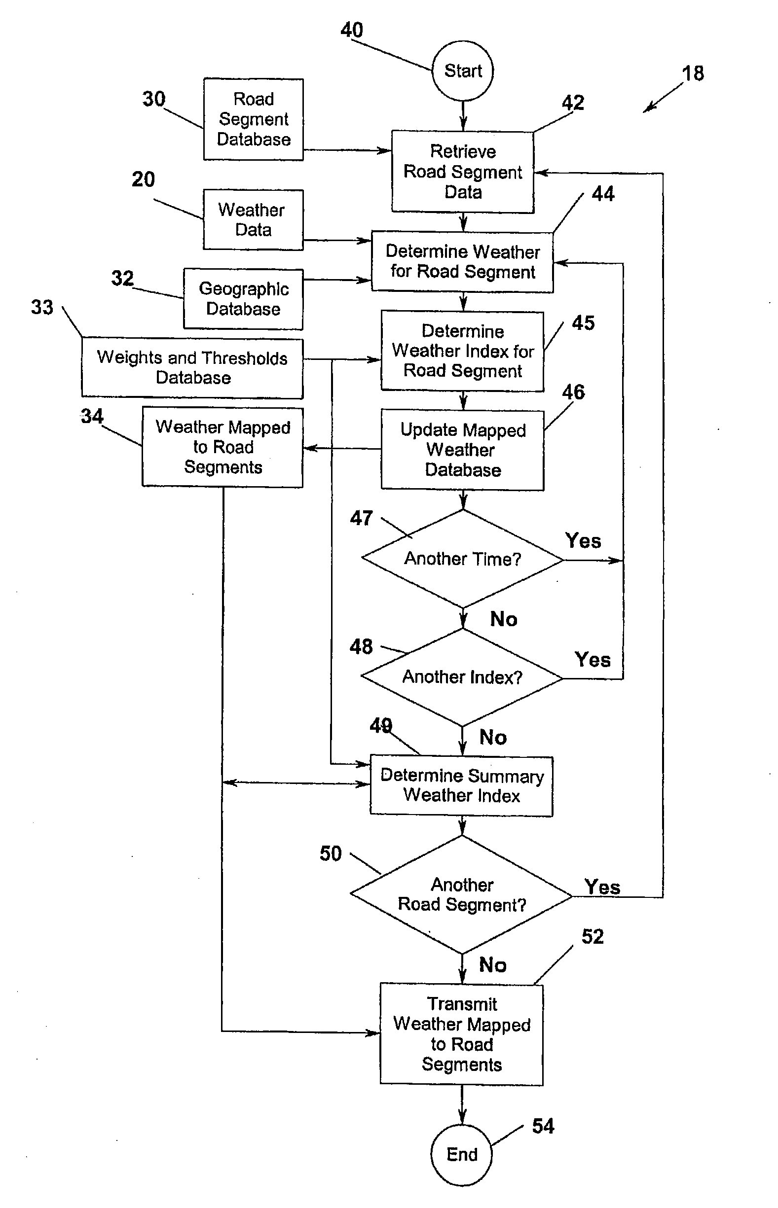
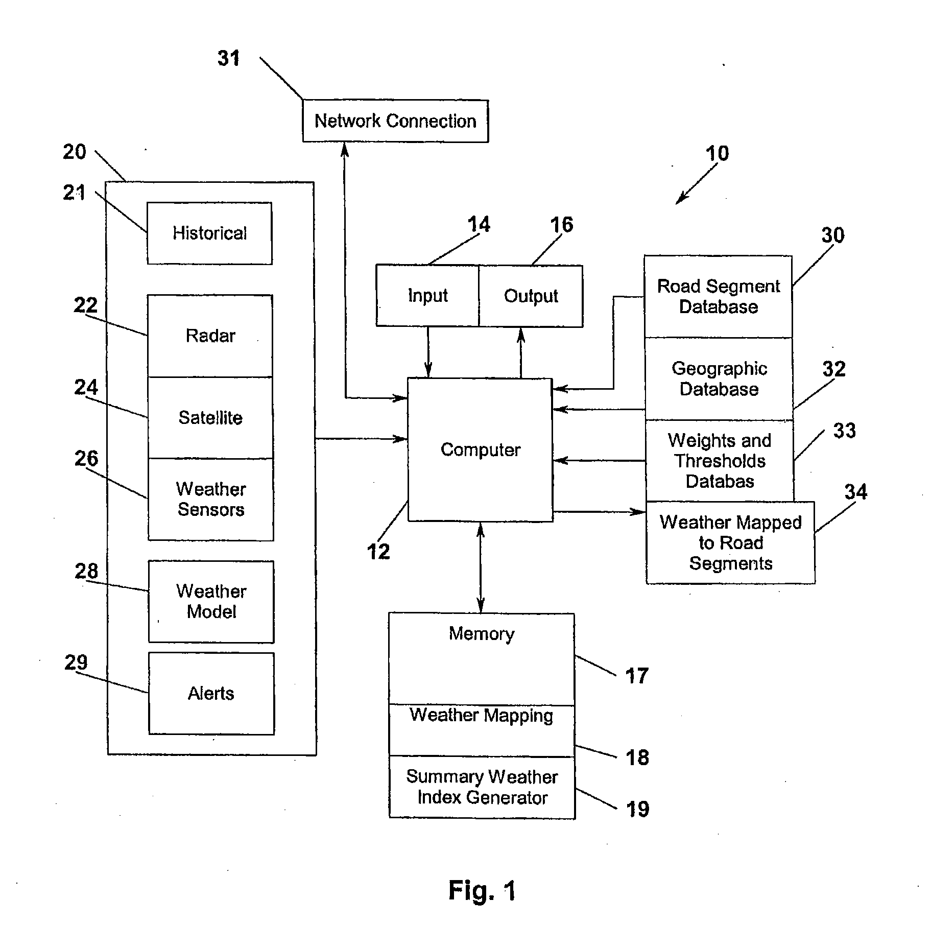
[0021]An exemplary system 10 for mapping weather data to road segments in accordance with the present invention will be described in detail with reference to FIG. 1. A system 10 for mapping weather data to road segments in accordance with an embodiment of the present invention preferably is implemented in software running on a conventional computer system 12. The computer system 12 may be a single computer or multiple computers coupled together via a conventional network for operation together in a conventional manner. The computer system 12 preferably is provided with conventional input 14 (keyboard, mouse, etc.) and output 16 (monitor, printer) or display devices to allow an operator of the system 10 to interact therewith in a conventional manner.

[0022]The computer system 12 is preferably also provided with memory 17 which may be provided in the form of one or more conventional memory devices (e.g., ROM, RAM, disc storage, etc.). Such memory 17 preferably contains weather mapping ...


PUM


Abstract

A computer-implemented method for generating a weather index mapped to a road segment for a particular time frame includes receiving weather condition information for a plurality of time periods, parsing the weather condition information to determine weather conditions for a road segment defined by a starting point and an ending point for the plurality of time periods, and generating a plurality of weather indices for the road segment. Each weather index is associated with one of the plurality of time periods and is representative of a predicted traffic impact based on historical information of the received weather conditions for the road segment. The plurality of time periods includes at least one future time period and the weather condition information includes forecasted weather information.

Description

CROSS-REFERENCE TO RELATED APPLICATIONS[0001]This application claims priority on U.S. Provisional Application No. 61 / 026,011, filed Feb. 4, 2008, the entirety of which is herein incorporated by reference.FIELD OF THE INVENTION[0002]The present invention pertains generally to systems and methods for generating weather and traffic information and for presenting weather and traffic reports and forecasts and the like, and, more specifically, to systems and methods for providing past, current, and forecast weather condition information for use in traffic forecasting, route navigation, traffic flow, and routing, and more particularly, to the generation of information and indexes for specific road segments based on past, present, and future weather conditions.BACKGROUND OF THE INVENTION[0003]Weather is one of the most significant conditions that affect how people and goods get from one location to another. The ability to easily make travel decisions based on weather conditions is important...

Claims


Application Information

Patent Timeline
IPC IPC(8): G08G1/00G01C21/36G01W1/00G06F19/00
CPCG01C21/26G08G1/096888G08G1/096758G01W1/10
Inventor KELLY, TERENCE F.MARSH, VICTOR W.KELLY, CHRISTOPHER W.BAIRD, KEVIN E.
Owner DTN LLC
Learn More