
Measurement Level Integration of GPS and Other Range and Bearing Measurement-Capable Sensors for Ubiquitous Positioning Capability

a technology of ubiquitous positioning capability and measurement level, applied in the direction of measurement devices, instruments, satellite radio beaconing, etc., can solve the problems of optimum number of satellites required to accurately determine the position of satellite receivers that cannot be used under certain conditions, and the number of satellites to become less than what is used

Inactive Publication Date: 2010-07-01
GM GLOBAL TECH OPERATIONS LLC
View PDF20 Cites 129 Cited by
  • Summary
  • Abstract
  • Description
  • Claims
  • Application Information

AI Technical Summary

Benefits of technology

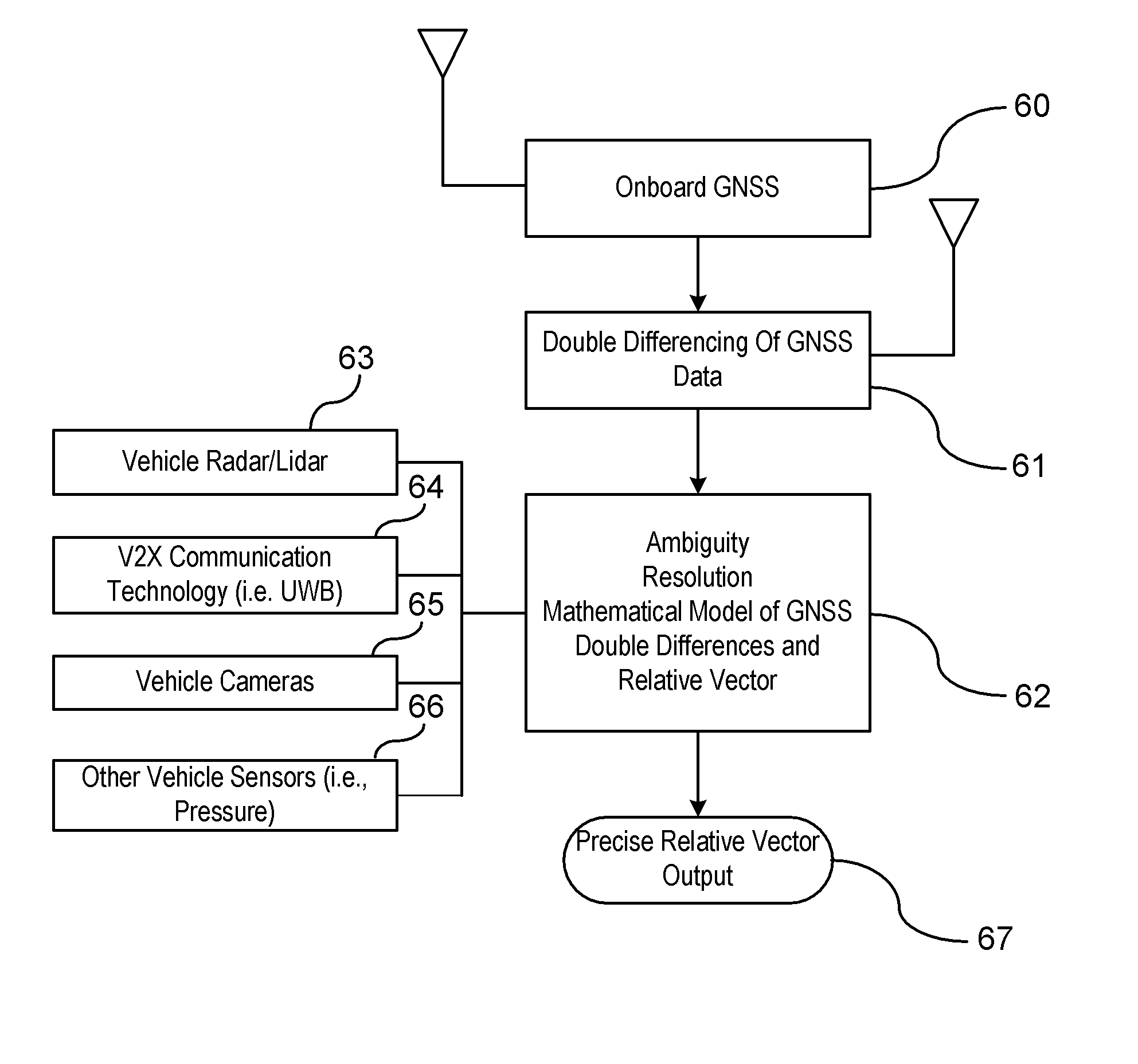
[0006]In an embodiment of the invention, a vehicle positioning system includes a host vehicle global positioning system for determining a global position of a host vehicle. A vehicle-to-entity communication system is provided for exchanging GPS data and alternative vehicle position data between a host vehicle and remote vehicles. A processing unit stores GPS measurement data from remote vehicles. The GPS measurement data of the remote vehicles and the host vehicle are processed within the processing unit for determining precise positioning of the host vehicle utilizing a real time kinematics positioning technique. The alternative vehicle position data is processed in cooperation with data output from the real time kinematics positioning technique to compensate for less than an optimum number of satellites required for the real time kinematics position processing technique applied between the host vehicle and the remote vehicles.

Problems solved by technology

Due to natural and man-made obstructions (e.g., buildings) or natural obstructions (i.e., dense tree cover), the optimum number of satellites required to accurately determine a position of the satellite receiver may not be available under certain conditions.
Other errors such as orbital errors of a satellite, poor geometry, atmospheric delays, multi-path signals, or clock errors may cause the number of satellites to become less than what is used to accurately determine the position of the receiver.

Method used


Image

  • Measurement Level Integration of GPS and Other Range and Bearing Measurement-Capable Sensors for Ubiquitous Positioning Capability
  • Measurement Level Integration of GPS and Other Range and Bearing Measurement-Capable Sensors for Ubiquitous Positioning Capability
  • Measurement Level Integration of GPS and Other Range and Bearing Measurement-Capable Sensors for Ubiquitous Positioning Capability

Examples


Embodiment Construction

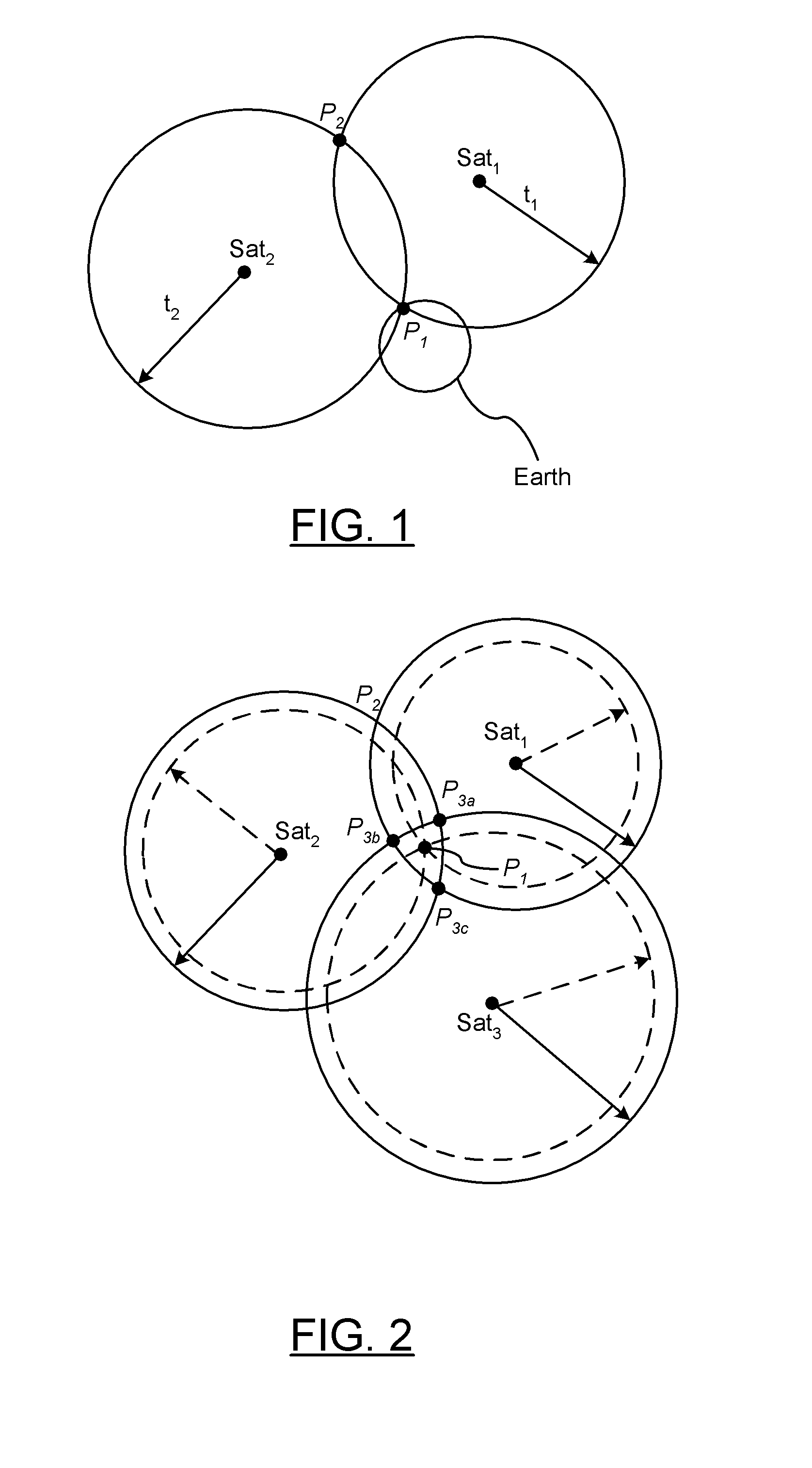
[0017]The global positioning satellite constellation includes at least 24 or more satellites orbiting the earth in a predetermined path of travel continuously transmitting time marked data signals. Navigation satellite receivers receive the transmitted data and use this information to determine its absolute position. In viewing the earth in a two dimensional plane, each point on the earth is identified by two coordinates. The first coordinate represents latitude and the second point represents a longitude. To determine a position in the two dimensional plane, at least three satellites are required as there are three unknowns, two position unknowns and the receiver clock timing error which also treated as an unknown. Some receivers may assume that the altitude stays the same for short duration such that position can be determined with only three satellites; however, if altitude is taken into consideration which is the case for most applications, then at least a minimum of four satell...


PUM


Abstract

A system and method are provided for determining a position of a host vehicle using a real time kinematics positioning technique when less than an optimal number of satellites are available for determining the position of the host vehicle. GPS data is retrieved from the host vehicle. GPS data is retrieved from vehicles remote from the host vehicle. Alternative vehicle position related data is retrieved. The position of the host vehicle is determined utilizing the real time kinematics positioning technique as a function of the retrieved GPS data of the host and remote vehicles and the alternative vehicle position data. The position of the host vehicle is utilized in a vehicle application.

Description

CROSS-REFERENCE TO RELATED APPLICATIONS[0001]This application claims priority of U.S. Provisional Application Ser. No. 61 / 141,297 filed Dec. 30, 2008, the disclosure of which is incorporated by reference.BACKGROUND OF INVENTION[0002]An embodiment relates generally to GPS positioning of moving or stationary entities using real time kinetics (RTK) or similar processing methods.[0003]Global Positioning System (GPS) or other Global Navigation Satellite System (GNSS) receivers operate by tracking line of sight signals. These receivers typically require at least four or more satellites to be continuously available in an unobstructed line of sight of a satellite receiver on a vehicle. Due to natural and man-made obstructions (e.g., buildings) or natural obstructions (i.e., dense tree cover), the optimum number of satellites required to accurately determine a position of the satellite receiver may not be available under certain conditions. Other errors such as orbital errors of a satellite,...

Claims


Application Information

Patent Timeline
IPC IPC(8): G01S19/45
CPCG01S5/0072G01S19/43G01S19/45
Inventor BASNAYAKE, CHAMINDA
Owner GM GLOBAL TECH OPERATIONS LLC
Learn More