Method for implementing GPS surveying field work planning using 3D topographic informaiton and method for analyzing 3D topographic information

a topographic information and 3d technology, applied in the field of implementing gps surveying field work planning using 3d topographic information, can solve the problems of inaccurate terrain contour, unsatisfactory gps positioning accuracy, and inability to estimate the effect of terrain obstruction on satellite signals, so as to improve the efficiency of field work planning

Inactive Publication Date: 2010-08-12
NAT TAIWAN UNIV
View PDF7 Cites 9 Cited by
  • Summary
  • Abstract
  • Description
  • Claims
  • Application Information

AI Technical Summary

Benefits of technology

[0009]In one embodiment, the present invention provides a method for implementing GPS surveying field work planning using 3D topographic information. The method includes steps of: obtaining three dimensional topographic information according to the location of a GPS receiver; obtaining maximum the topographic elevation angle from the GPS receiver in each azimuths according to the three dimension topographic information; determining the elevation angles of satellites from the GPS receiver according to the satellite ephemeris or almanacs; determining whether observation information is visible according to the maximum topographic elevation angle information, and the elevation angle of a satellite along the same azimuth; and estimating a GPS receiver positioning accuracy according to the predicted visible satellite observations. Thus, an improved visible analysis of 3D topographic information is obtained and the satellite positioning accuracy is precisely predicted. As a result, the field work planning efficiency is improved.
[0010]In another embodiment, the present invention provides a method for analyzing 3D topographic information. The method includes steps of: obtaining topographic information; determining a location and a analysis area; obtaining topographic heights in the area with adaptive grid sizes according to the topographic variations, wherein the grid sizes are proportional to the distance between the receiver's location and the sampling points in the best-contemplated case; and obtaining maximum topographic elevation angle information according to the topographic heights and the height of the receiver's location. Note that self-adaptive non-equivalent interval sampling is used to speed up the analysis of 3D information of a large size to obtain topographic information approximating to the real field terrain.

Problems solved by technology

Thus, the terrain contour is not precise and may be unsatisfactory when the required field information is not enough.
Consequently, estimating terrain obstruction effect on satellite signals and GPS positioning accuracy may be unsatisfactory.

Method used


Image

  • Method for implementing GPS surveying field work planning using 3D topographic informaiton and method for analyzing 3D topographic information
  • Method for implementing GPS surveying field work planning using 3D topographic informaiton and method for analyzing 3D topographic information
  • Method for implementing GPS surveying field work planning using 3D topographic informaiton and method for analyzing 3D topographic information

Examples


Embodiment Construction

[0020]The following description is of the best-contemplated mode of carrying out the invention. This description is made for the purpose of illustrating the general principles of the invention and should not be taken in a limiting sense. The scope of the invention is best determined by reference to the appended claims.

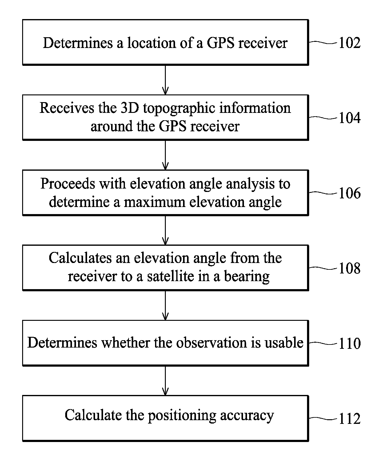
[0021]FIG. 1 is a flow chart illustrating a method for implementing GPS surveying field work planning using 3D topographic information according to the embodiment of the present invention. In step 102, a user determines a location of a GPS receiver. The user selects a location for settling the GPS receiver on a three dimensional topographic map, and sets relevant parameters such as measuring timing, etc. Next, in step 104, the user receives the 3D topographic information around the GPS receiver. In the embodiment, the Digital Surface Model (DSM) is used as the 3D topographic information.

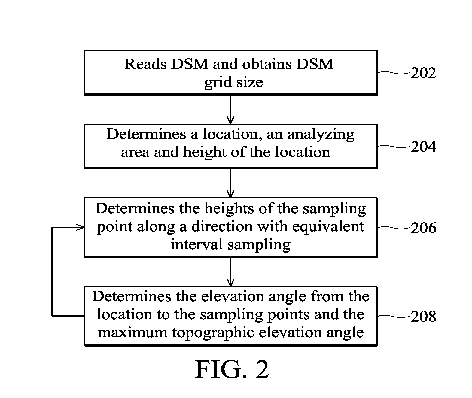
[0022]In step 106, the user proceeds with elevation angle analysis (i.e. terrain ob...


PUM


Abstract

A method for implementing GPS surveying field work planning by using three dimensional topographic information is provided, comprising the steps of: obtaining three dimensional topographic information according to the location of a GPS receiver; obtaining maximum topographic elevation angle information from the GPS receiver to the terrain for each azimuth using the three dimension topographic information; obtaining elevation angle of satellites from the GPS receiver according to the satellite ephemeris or almanac; determining whether observation is usable according to the maximum topographic elevation angle information along the satellite bearings, and the elevation angle of satellites; and estimating the positioning accuracy according to the usable satellite observations.

Description

CROSS REFERENCE TO RELATED APPLICATION[0001]This Application claims priority of Taiwan Patent Application No. 98104017, filed on Feb. 9, 2009, the entirety of which is incorporated by reference herein.BACKGROUND OF THE INVENTION[0002]1. Field of the Invention[0003]The present invention relates to a method for implementing GPS surveying field work planning, and in particular relates to a method for implementing GPS surveying field work planning using 3D topographic information.[0004]2. Description of the Related Art[0005]Typically, software such as Trimble Planning is used for implementing GPS surveying field work planning. The software is used to make preliminary estimation on surveying timing, planning location and measurement quality before a real field survey. The software can generate visible satellite number and positioning accuracy graphs, etc. for analysis and simulations. Satellite visibility analysis used for predicting visible observations and estimating positioning accura...

Claims


Application Information

Patent Timeline
Patent Type & Authority Applications(United States)
IPC IPC(8): G01S1/00
CPCG06T17/05G01S19/28
Inventor HAN, JEN-YULEE, PO-HAN
Owner NAT TAIWAN UNIV
Why Eureka
Try Eureka