Spatial indexing method and apparatus for navigation system for indexing and retrieval of XML map data

Active Publication Date: 2010-11-11
ALPINE ELECTRONICS INC
View PDF15 Cites 33 Cited by
  • Summary
  • Abstract
  • Description
  • Claims
  • Application Information

AI Technical Summary

Benefits of technology

[0022]Another aspect of the present invention is an apparatus for efficiently indexing the map cells and retrieving the map data from the map cells for implementing the steps defined in the methods of the present invention noted above. The apparatus includes various means to assign the index numbers to the map cells and selects the map cells to retrieve the XML map data therefrom. The apparatus is able to improve the efficiency and operability of the navigation system using the XML format map data constructed in a layered structure based on administrative areas or jurisdictions by dividing the XML map data into a plurality of small map cells so that the XML map data that is actually necessary is retrieved and processed by the resources of the navigation system.
[0023]According to the present invention, the method and apparatus efficiently assigns the spatial index numbers to the map cells that divide an area which is a unit of administrative region into a plurality of small

Problems solved by technology

Thus, the process of storing, retrieving, and processing such a large amount of map data can be time consuming and needs a high processing power of the navigation system.
However, this configuration of the map data and its indexing is inflexible in handling the map data.
The amount of memory to read and the load to the disk input and output can also be significant.
Extraction of map data based

Method used


Image

  • Spatial indexing method and apparatus for navigation system for indexing and retrieval of XML map data
  • Spatial indexing method and apparatus for navigation system for indexing and retrieval of XML map data
  • Spatial indexing method and apparatus for navigation system for indexing and retrieval of XML map data

Examples


Embodiment Construction

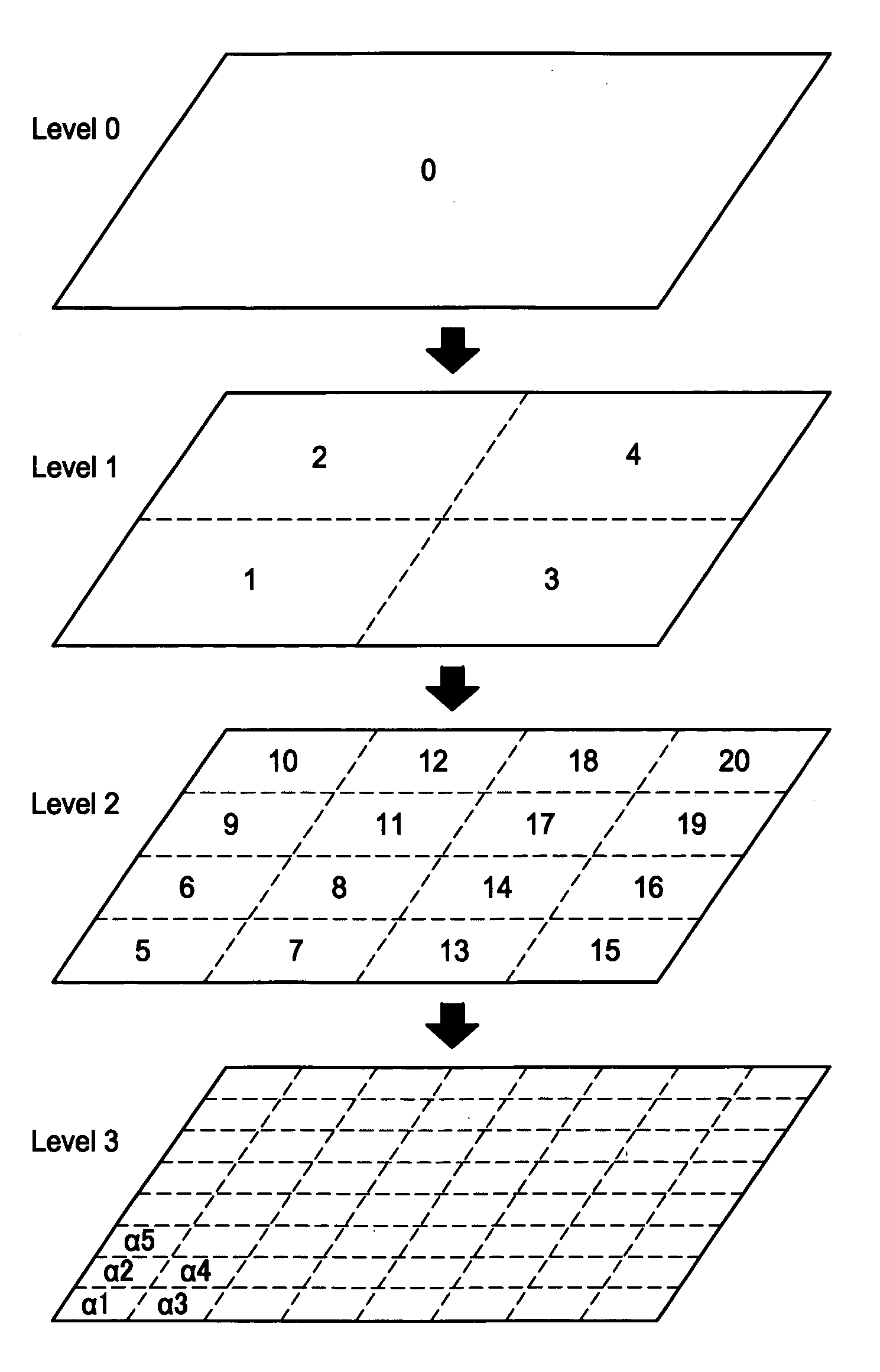
[0045]The spatial indexing method and apparatus of the present invention will be described in more detail with reference to the accompanying drawings. The spatial indexing method and apparatus of the present invention is advantageously applied to a navigation system for indexing and retrieving map data in the format of an extensible markup language (XML) and scalable vector graphics (SVG). It should be noted that although the present invention will be described for the case where the spatial indexing method is implemented to a vehicle navigation system, the present invention can be implemented to any other systems for indexing and searching the map data for a navigation purpose.

[0046]An XML is an extensible markup language that has been standardized and is gaining acceptance for many types of applications. Further, the XML is a markup language that is easy to read as it uses human-readable tags to describe the data. The extensible language allows programmers to define new descriptio...


PUM


Abstract

A method and apparatus efficiently assigns the spatial index numbers to map cells that divide an area which is a unit of administrative region into a plurality of small units. The method includes the steps of: establishing a plurality of map cells that divide an administrative region expressed by XML map data which is configured in a multiple-layered structure; determining a layer in the XML map data on which the map cells are established; selecting a type of tracing curve for sequentially indexing the plurality of map cells; assigning index numbers consecutively to the map cells with the sequence of the tracing curve; and repeating foregoing steps for all of the map cells in all of the layers of the XML map data, thereby creating a map database in the XML format with the spatial indexes for all of the map cells.

Description

FIELD OF THE INVENTION[0001]This invention relates generally to an indexing and searching map data in the XML format, and more particularly, to a method and apparatus for a navigation system for spatial indexing the XML navigation map data and searching of a map area with small map cells based on the spatial indexing by means of space tracing curves such that a multi-layer structure of the map data can be used and two dimensional data can be handled as one dimensional data for indexing and addressing the map cells.BACKGROUND OF THE INVENTION[0002]A navigation system performs travel guidance for enabling a user to easily and quickly reach the selected destination. A typical example is a vehicle navigation system where a vehicle is equipped with a navigation function to guide a driver to a destination through a calculated route. Such a navigation system detects the position of the user's vehicle, and reads out map data pertaining to an area at the current vehicle position from a data ...

Claims


Application Information

Patent Timeline
IPC IPC(8): G06F7/00
CPCG06F17/30241G06F16/29
Inventor MOTOYAMA, MASAKI
Owner ALPINE ELECTRONICS INC
Why Eureka
Try Eureka