Pseudolite-based navigation system

a navigation system and pseudolite technology, applied in the direction of instruments, measurement devices, electrical appliances, etc., can solve the problems of inability to calculate the location solution of portable devices, inability to measure the location of satellites, and inability to utilize general portable devices having gnss receivers in existing pseudolite-based navigation systems

Inactive Publication Date: 2012-08-30
SEOUL NAT UNIV R&DB FOUND
View PDF12 Cites 14 Cited by
  • Summary
  • Abstract
  • Description
  • Claims
  • Application Information

AI Technical Summary

Benefits of technology

[0016]The pseudolite-based navigation system according to the present disclosure may calculate a navigation solution of a t

Problems solved by technology

In a case of the satellite navigation system, since the intensity of radio wave sent from the GNSS satellite is weak, if a satellite is not observed due to geographic features so that the radio wave is not received, it is impossible to measure the location of the satellite.
However, in an existing pseudolite-based navigation system, in a case where a general comm

Method used


Image

  • Pseudolite-based navigation system
  • Pseudolite-based navigation system
  • Pseudolite-based navigation system

Examples


Embodiment Construction

[0021]Hereinafter, a pseudolite-based navigation system according to a preferred embodiment of the present disclosure will be described with reference to the accompanying drawings.

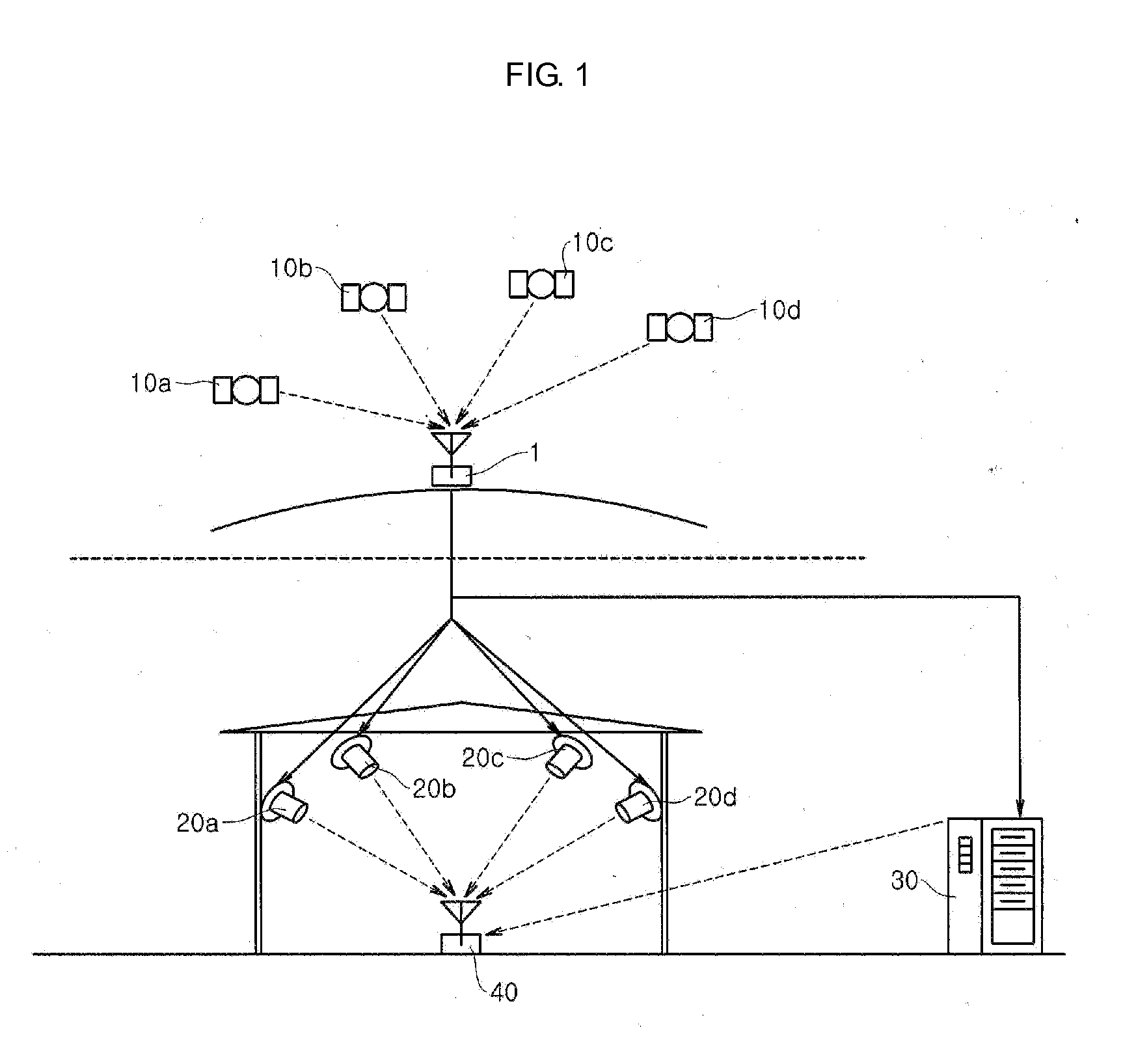
[0022]FIG. 1 is a schematic view showing a pseudolite-based navigation system according to an embodiment of the present disclosure.

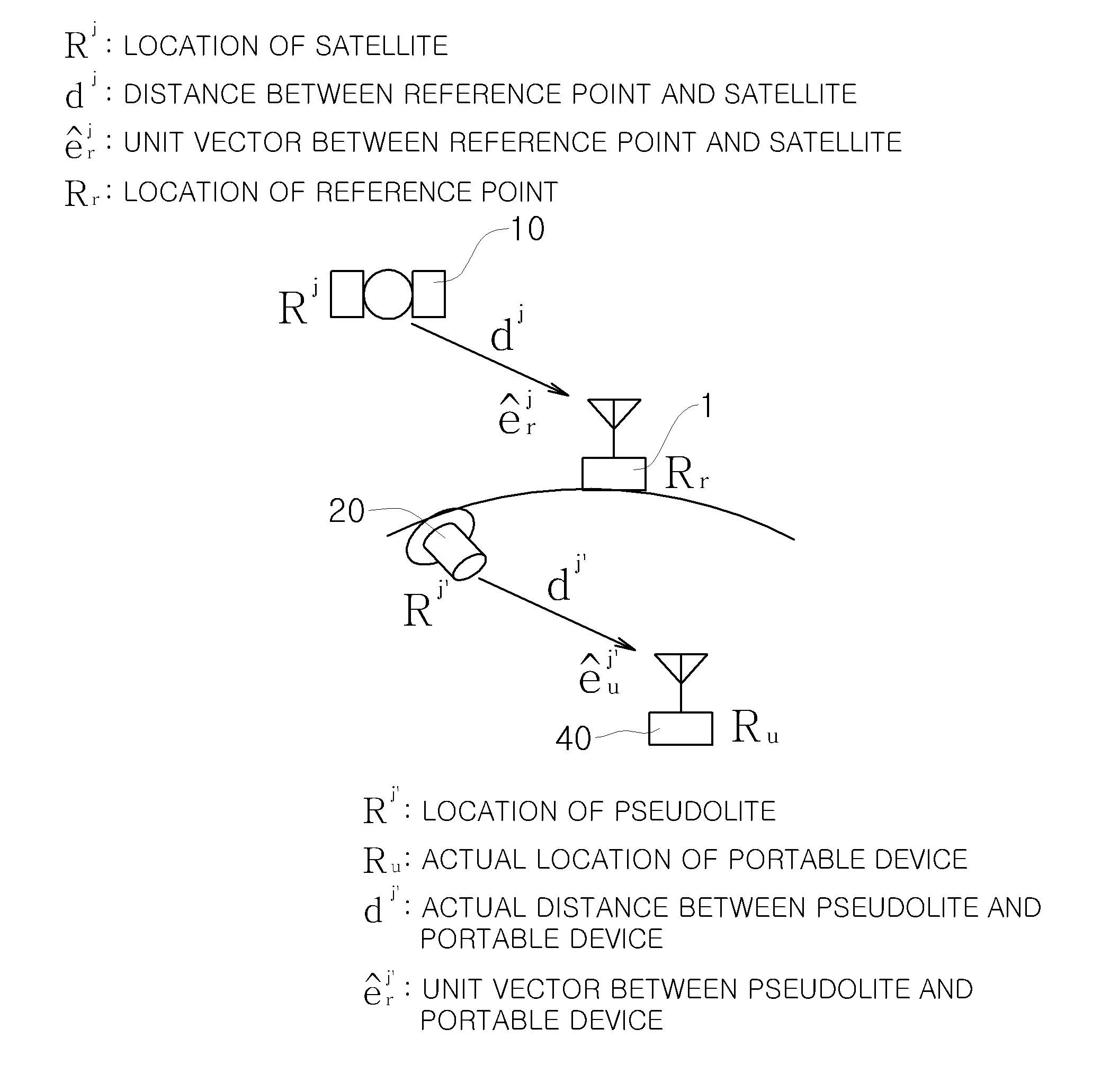
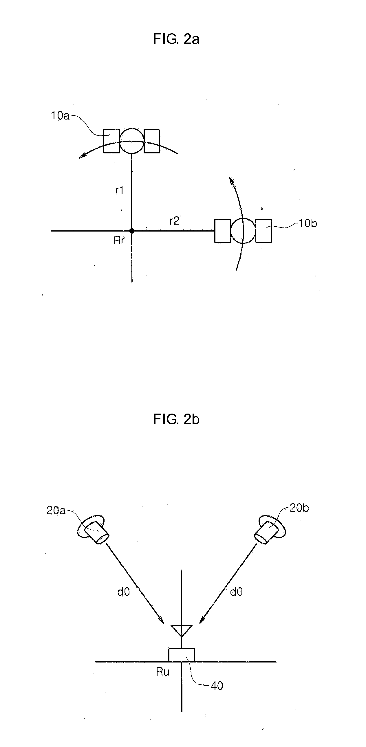
[0023]Referring to FIG. 1, the pseudolite-based navigation system according to the present disclosure includes a plurality of virtual GNSS satellites 10a, 10b, 10c, 10d, a plurality of pseudolites 20a, 20b, 20c, 20d, and a portable device 40, and may further include a data server 30 selectively. The portable device 40 includes a communication module (not shown), a GNSS receiver (not shown) and a computing unit (not shown).

[0024]The pseudolites 20a, 20b, 20c, 20d generates and sends a navigation signal which simulates a virtual GNSS satellite signal, and transmits a navigation message having the same format and content as the GNSS satellite 10a, 10b, 10c, 10d. Here, the pseudoli...


PUM


Abstract

The pseudolite-based navigation system includes: a plurality of pseudolites for transmitting a navigation signal which simulates a satellite signal transmitted from a plurality of GNSS satellites; and a portable device capable of calculating a navigation solution for a location thereof based on the signal received from the pseudolites, wherein the portable device includes: a GNSS receiver for receiving the navigation signal of the pseudolites and calculating a navigation solution based on the navigation signal; and a computing unit for calculating a final navigation solution by integrating the navigation solution calculated by the GNSS receiver and the location information of the GNSS satellites and the pseudolites.

Description

CROSS-REFERENCE TO RELATED APPLICATION[0001]This application claims priority to Korean Patent Application No. 10-2011-0017165, filed on Feb. 25, 2011, and all the benefits accruing therefrom under 35 U.S.C. §119, the contents of which in its entirety are herein incorporated by reference.BACKGROUND[0002]1. Field[0003]The present disclosure relates to a pseudolite-based navigation system capable of precisely calculating a navigation solution by using a general common global navigation satellite system (GNSS) receiver and an additional computing unit, and more particularly, to a pseudolite-based navigation system capable of precisely calculating a navigation solution for a location of a portable device by receiving a navigation signal transmitted from a pseudolite that simulates and broadcasts a GNSS satellite signal and integrating arrangement information of the simulated GNSS satellite group and actual geometric arrangement information of a pseudolite.[0004]2. Description of the Rela...

Claims


Application Information

Patent Timeline
IPC IPC(8): G01S19/11
CPCG01S19/11G01S19/41H04W64/00
Inventor KEE, CHANGDONSO, HYOUNGMINKIM, CHONGWON
Owner SEOUL NAT UNIV R&DB FOUND
Why Eureka
Try Eureka