Method for mapping the surroundings of a vehicle

a vehicle and surroundings technology, applied in the direction of pedestrian/occupant safety arrangement, instruments, reradiation, etc., to achieve the effect of reducing computing time, reducing computing time, and reducing computing tim

Active Publication Date: 2012-11-29
ROBERT BOSCH GMBH
View PDF3 Cites 83 Cited by
  • Summary
  • Abstract
  • Description
  • Claims
  • Application Information

AI Technical Summary

Benefits of technology

[0033]If both coordinate points, by which the object is described, are located on the same side of the travel path, it is sufficient if only the coordinate point of the object closest to the travel path is used to determine the degree of overlap. Computing time may be saved thereby, which makes it possible to determine the collision probability more quickly. The use of the coordinate point closest to the travel path is sufficient, since the collision probability decreases as the distance from the vehicle path increases. In addition, the coordinate point closest ...

Problems solved by technology

In unforeseen situations, in particular, for example if a previously unidentified obstacle appears during park...

Method used


Image

  • Method for mapping the surroundings of a vehicle
  • Method for mapping the surroundings of a vehicle
  • Method for mapping the surroundings of a vehicle

Examples


Embodiment Construction

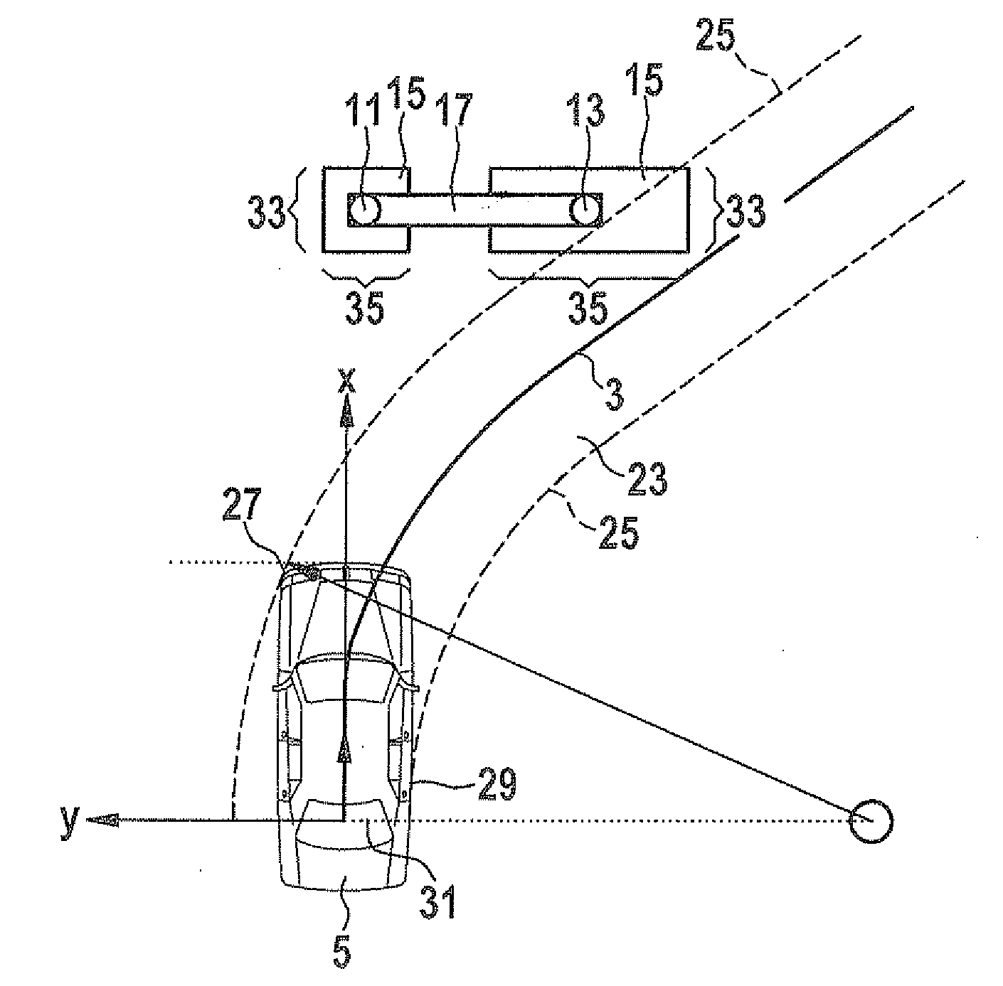
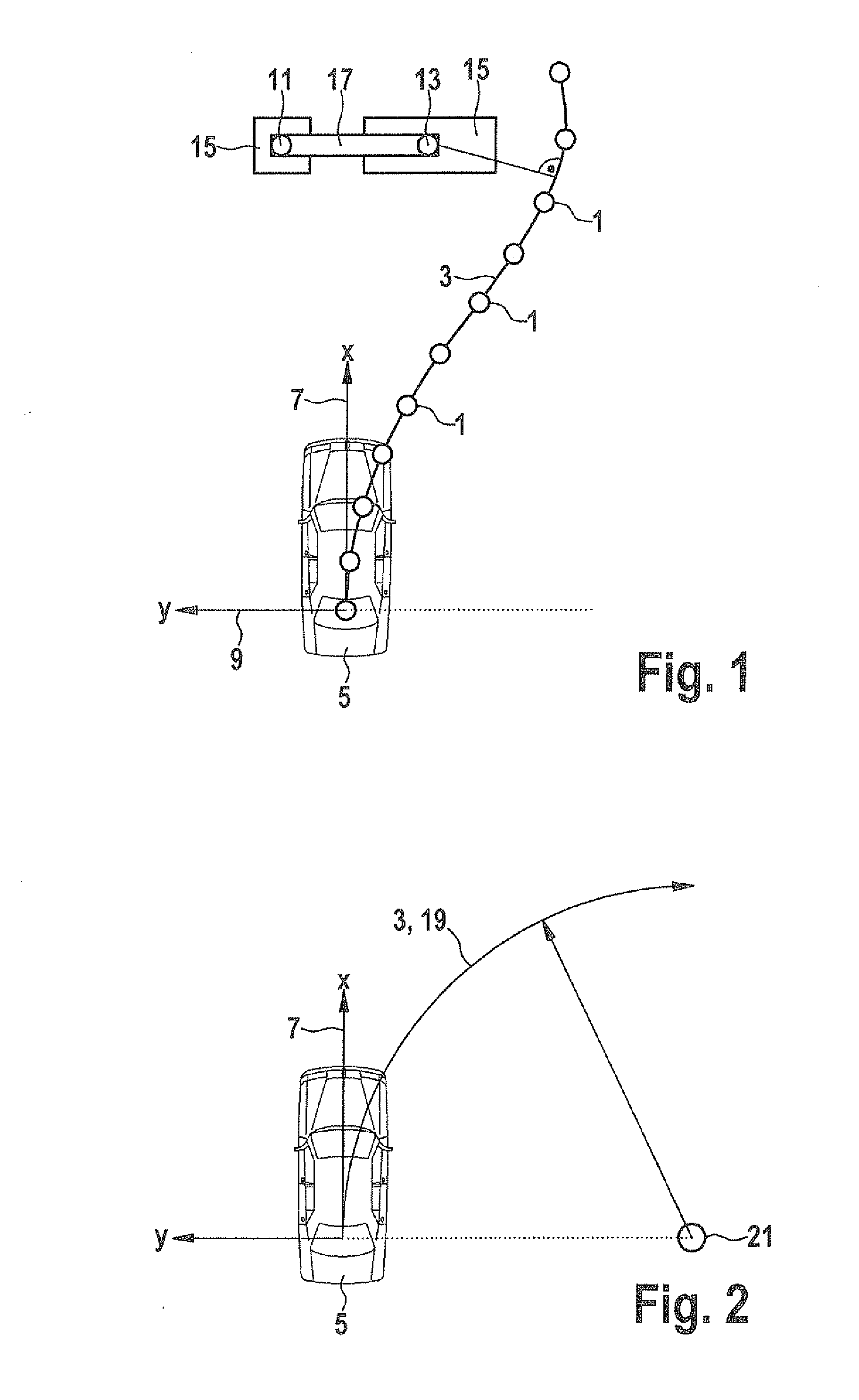
[0045]FIG. 1 shows a course trajectory made up of trajectory planning points for bypassing an object.

[0046]A course trajectory 3 which is made up of trajectory planning points 1 is used, for example, in a guided parking maneuver which was preceded by a corresponding trajectory planning. For this purpose, a suitable parking space is first measured and course trajectory 3 is calculated from the data measured in this manner using trajectory planning points 1. Course trajectory 3 is usually the trajectory which is traveled by the central point of the rear axle. Trajectory planning points 1, which characterize course trajectory 3, may be situated, for example, equidistantly on course trajectory 3. Alternatively, however, it is also possible for the distance between trajectory planning points 1 to be a function of the particular trajectory curvature of course trajectory 3. In the case of a larger trajectory curvature, for example, a smaller distance between trajectory planning points 1 is...


PUM


Abstract

A method for mapping surroundings of a vehicle, objects in the surroundings of the vehicle being detected with the aid of sensors and particular detected objects being described by two coordinate points and also by a position fuzziness assigned to the particular coordinate point, the coordinate points and the position fuzziness values being stored in an interface in the form of data which may be accessed by driver assistance systems of the vehicle. A method is also described for ascertaining the collision probability of a vehicle with an object, in which the surroundings of the vehicle are initially mapped using the method for mapping the surroundings of a vehicle, a travel path to be traveled by the vehicle is ascertained in a subsequent step, and the degree of overlap between the object and the travel path and also the collision probability are finally determined, taking the position fuzziness into account.

Description

FIELD OF THE INVENTION[0001]The present invention is directed to a method for mapping the surroundings of a vehicle. The present invention furthermore relates to a method for ascertaining the collision probability of a vehicle with an object.BACKGROUND INFORMATION[0002]In driver assistance systems which take into account the vehicle surroundings, for example systems which support the motor vehicle driver in parking or systems which are used to maintain a sufficiently great distance from a preceding vehicle, it is necessary to effectively detect the surroundings. In systems for supporting the parking maneuver, for example, the surroundings are detected with the aid of ultrasonic sensors. If a larger area of the vehicle surroundings is to be monitored, in particular, radar sensors or cameras are also used.[0003]Parking assistance systems which guide the driver into a parking space are discussed for example in DE-A 10 2004 047484 or also in EP-A 1 270 367. In parking assistance systems...

Claims


Application Information

Patent Timeline
IPC IPC(8): G08G1/16B60W40/04G01S13/931B60W30/08B60W50/08
CPCB60T2201/10B60W30/0956B60W50/14B62D15/0285G01S2013/9389G01S2013/9314G01S2013/9364G01S2013/9353G01S13/931G01S2013/9324G01S2013/93275G01S2013/932B60R21/013
Inventor PAMPUS, CHRISTIANSCHMID, DIRKSCHERL, MICHAELURBAN, WERNERFEHSE, MEIKEZIMMERMANN, UWESCHOENHERR, MICHAEL
Owner ROBERT BOSCH GMBH
Why Eureka
Try Eureka