Weather and satellite model for estimating solar irradiance

a satellite model and solar irradiance technology, applied in load forecasting in ac networks, instruments, lighting and heating apparatus, etc., can solve problems such as a wide margin of error in satellite-based methodologies, a lack of precision to a) fully, and a challenge in developing irradiance maps

Active Publication Date: 2013-06-27
LOCUS ENERGY
View PDF2 Cites 79 Cited by
  • Summary
  • Abstract
  • Description
  • Claims
  • Application Information

AI Technical Summary

Benefits of technology

[0006]In the case of global horizontal irradiance (GHI), the total amount of solar irradiance reaching a surface horizontal to the ground, irradiance is composed of diffuse horizontal irradiance (DHI) and direct normal irradiance (DNI) corrected for solar position, with no ground reflected irradiance due to the horizontal positioning. Using this relationship and empirical studies, methodology was developed to estimate DNI, DHI, IPOA, plane of array direct irradiance (HBEAM), plane of array diffuse irradiance (HDIFF), and plane of array ground reflected irradiance (HGRF) from GHI. While this methodology has been proven effective, it is restricted to using GHI for making all estimates and is thus subject to biases and errors associated with the input. Additional types of solar irradiance observations, such as IPoA, would help to reduce model bias and improve accuracy. This methodology provides logic for improving estimates of solar irradiance components (GHI, DNI, DHI, IPoA, HBEAM, HDIFF, HGRF) by leveraging sensors recording GHI or IPoA and atmospheric solar irradiance models.

Problems solved by technology

Developing irradiance maps can be challenging because irradiance sensors are too expensive to deploy widely, and satellite-based methodologies tend to have wide margins of error.
Acquiring irradiance data generally comes from one of four sources, (1) Satellite-based irradiance estimates, which while fairly reliable over long time horizons, lack enough precision to a) fully characterize the potential solar resources for existing system performance assessments or, b) accurately estimate potential output from a new system under design consideration; (2) Weather station data from somewhere in the same region.
While this represents actually measured data, there are not many of these weather stations around, so the weather data is generally not precise enough for the location under consideration; (3) Historical irradiance studies: while these studies may provide reasonably accurate estimates based on historical experience, they do not solve the problem of the need for recent real-time and forecasted irradiance for specific locations; (4) One-off studies of irradiance: sometimes people may invest in irradiance monitoring equipment for a particular site that is under consideration for construction of a solar system.
While precise, this solution is generally extremely expensive and time consuming.
Many commonly deployed irradiance sensors do not provide information on the different direct, diffuse, and ground reflected irradiance components, however, and instead simply provide aggregate global horizontal irradiance (GHI) or plane of array irradiance (IPoA) measurements.
While this methodology has been proven effective, it is restricted to using GHI for making all estimates and is thus subject to biases and errors associated with the input.
A major obstacle to the usability of irradiance estimation models is the availability of input data.
Satellite coverage, historical imagery availability, imagery resolution, and the number of unique satellites are limited due to the costs associated with building and maintaining geostationary satellites.
Additionally, the image processing techniques required for satellite based irradiance estimation models can be too technical for some users to implement.
Standard quantitative weather variables lack the explanatory power of satellite imagery, because these variables describe aspects of the atmosphere, rather than overall conditions.

Method used


Image

  • Weather and satellite model for estimating solar irradiance
  • Weather and satellite model for estimating solar irradiance
  • Weather and satellite model for estimating solar irradiance

Examples


Embodiment Construction

[0027]The following detailed description is of the best currently contemplated modes of carrying out the invention. The description is not to be taken in a limiting sense, but is made merely for the purpose of illustrating the general principles of the invention, since the scope of the invention is best defined by the appended claims.

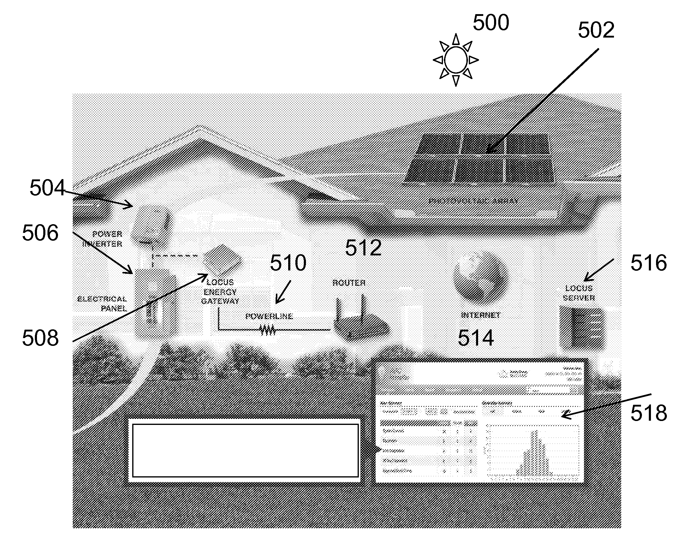
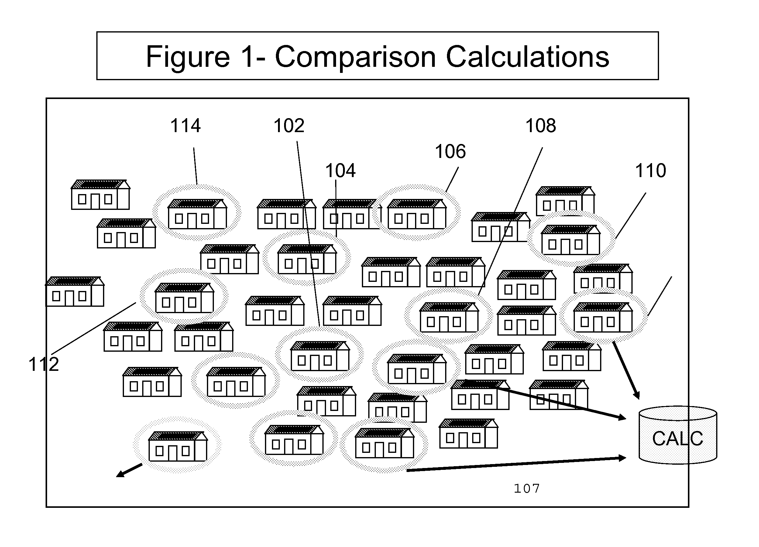
[0028]FIGS. 1-5 provide examples of a monitored electrical system (in this case a renewable power system and more specifically a photovoltaic array solar panel also referred to herein as a solar photovoltaic system or solar powered system) from which information may be obtained. According to the example shown, there is a server 10 and at least one monitored electrical system (e.g. 102, 104, 106, 108, 110, 112) which is provided to a user or consumer. There may be at least one data server (10), at least one generation monitoring device (16) in communication with the monitored electrical system (at premise monitored electrical system (30)) and at least on...


PUM


Abstract

Solar irradiance, the energy from the Sun's electromagnetic radiation, has a wide range of applications from meteorology to agronomy to solar power. Solar irradiance is primarily determined by a location's spatial relationship with the Sun and the atmospheric conditions that impact the transmission of the radiation. The spatial relationship between the Sun and a location on Earth is determined by established astronomical formulas. The impact of atmospheric conditions may be estimated via proxy using pixels from satellite imagery. While satellite-based irradiance estimation has proven effective, availability of the input data can be limited and the resolution is often incapable of capturing local weather phenomena. Brief qualitative descriptions of general atmospheric conditions are widely available from internet weather services at higher granularity than satellite imagery. This methodology provides logic for quantifying the impact of qualitative weather observations upon solar irradiance, and the integration of this methodology into solar irradiance estimation models.

Description

[0001]This application claims priority to provisional patent application No. 61 / 546,825 filed Oct. 13, 2011 entitled “Weather and Satellite Model for Estimating Solar Irradiance”, and is a continuation-in-part of application Ser. No. 12 / 777,224 entitled “IRRADIANCE MAPPING LEVERAGING A DISTRIBUTED NETWORK OF SOLAR PHOTOVOLTAIC SYSTEMS” which is a continuation-in-part of co-pending application Ser. No. 11 / 949,035 filed Dec. 2, 2007 now issued as U.S. Pat. No. 7,742,897 entitled “Systems and Methods for Monitoring and Diagnosing the Power Generated by Renewable Power Systems” and claims priority to and is a continuation-in-part of co-pending application Ser. No. 11 / 673,649 Feb. 12, 2007 entitled “Systems and Methods for Providing Renewable Power Systems by Aggregate Cost and Usage” all of which are incorporated herein by reference.[0002]With the increasing popularity of solar panels, it has become increasingly more desirable to map the relative concentration of solar radiation hitting...

Claims


Application Information

Patent Timeline
Patent Type & Authority Applications(United States)
IPC IPC(8): G06G7/48
CPCH02J3/383H02J13/0062Y02E10/563Y02E60/7838G01W1/10Y04S10/54Y04S40/124H02J2003/003G01W1/12F24S2201/00G06F30/20H02J3/003H02J2300/22H02J2300/24H02J3/381H02J13/00016H02J3/004Y02E10/56Y02E60/00
Inventor HERZIG, MICHAELWILLIAMS, MATTHEWKERRIGAN, SHAWN
Owner LOCUS ENERGY
Why Eureka
Try Eureka