Method of determining and validating navigational priority settings utilizing probe data

a technology of priority setting and probe data, applied in the field of system and method for determining and validating vehicle priority, can solve the problem of increasing difficulty in confirming the accuracy of these details

Active Publication Date: 2013-08-15
TOMTOM GLOBAL CONTENT
View PDF6 Cites 16 Cited by
  • Summary
  • Abstract
  • Description
  • Claims
  • Application Information

AI Technical Summary

Benefits of technology

[0010]The present invention provides advantages over the prior art by allowing for a detailed analysis of existing intersections and a determination of the rules that govern them without requiring the map developers to physically inspect a particular intersection. Additionally, the present invention provides advantages by allowing an analysis of real traffic patterns and comparing them to presumed priorities to either verify, correct, or even suggest changes to existing priorities.

Problems solved by technology

As the detail of such digital maps, and the navigation systems that utilize them, increases the ability to verify the accuracy of these details becomes increasing difficult.

Method used


Image

  • Method of determining and validating navigational priority settings utilizing probe data
  • Method of determining and validating navigational priority settings utilizing probe data
  • Method of determining and validating navigational priority settings utilizing probe data

Examples


Embodiment Construction

[0018]Referring to the Figures, wherein like numerals indicate like or corresponding parts throughout the several views, this invention pertains to digital transportation network navigation systems and to the digital maps, databases and devices used by navigation systems. By “digital transportation network”, it is meant to include digital mapping systems for various established transportation networks, including various roadway surfaces for motorized and non-motorized vehicles, walking, biking, skiing and hiking trails, and other established routes along which users of navigations devices travel for business or pleasure. For purposes of this invention, the term “roadway” is intended to be used in a most general way and to be inclusive of all paved and unpaved roads, paths, trails and the like for use by any type of vehicle or a pedestrian.

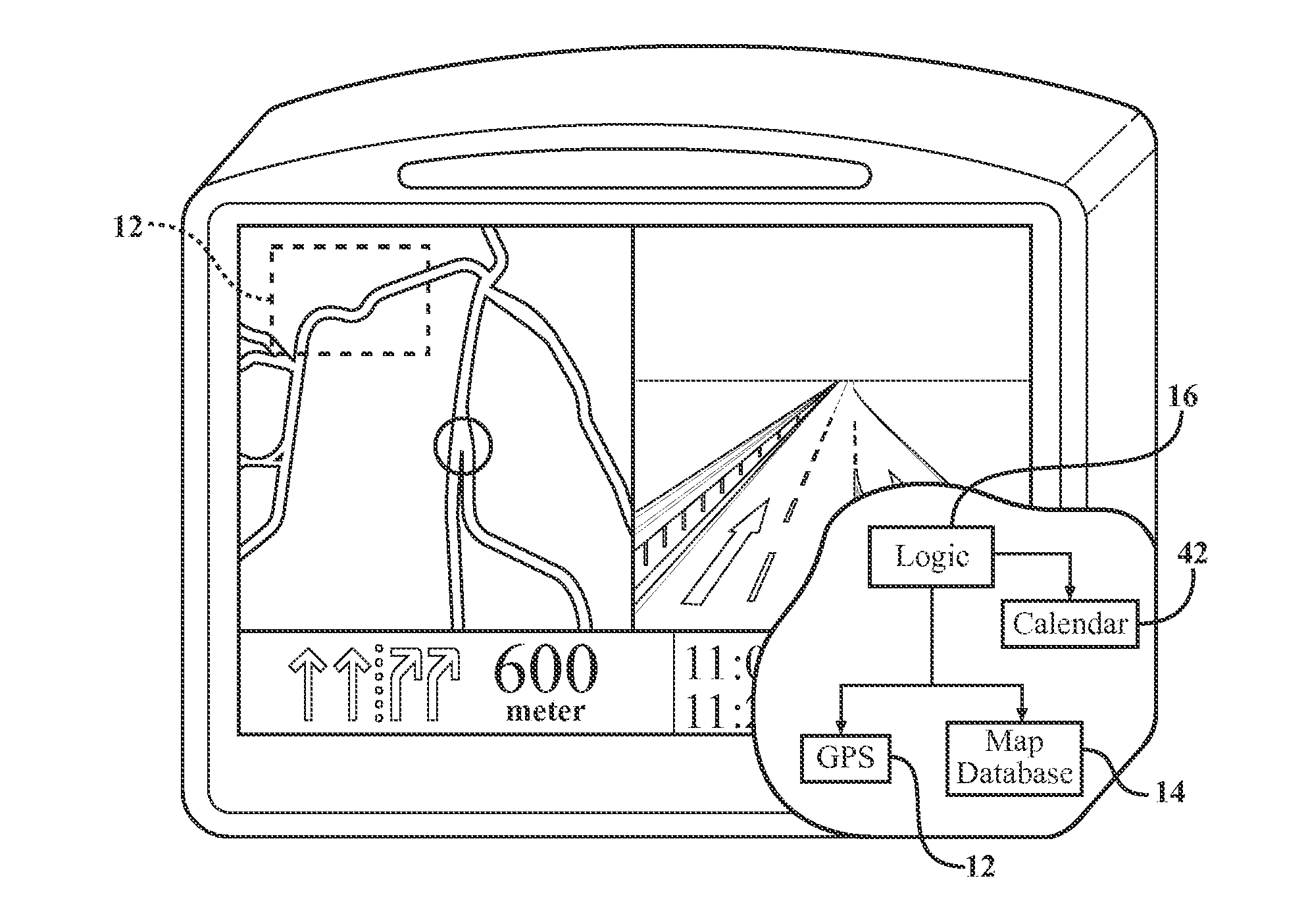
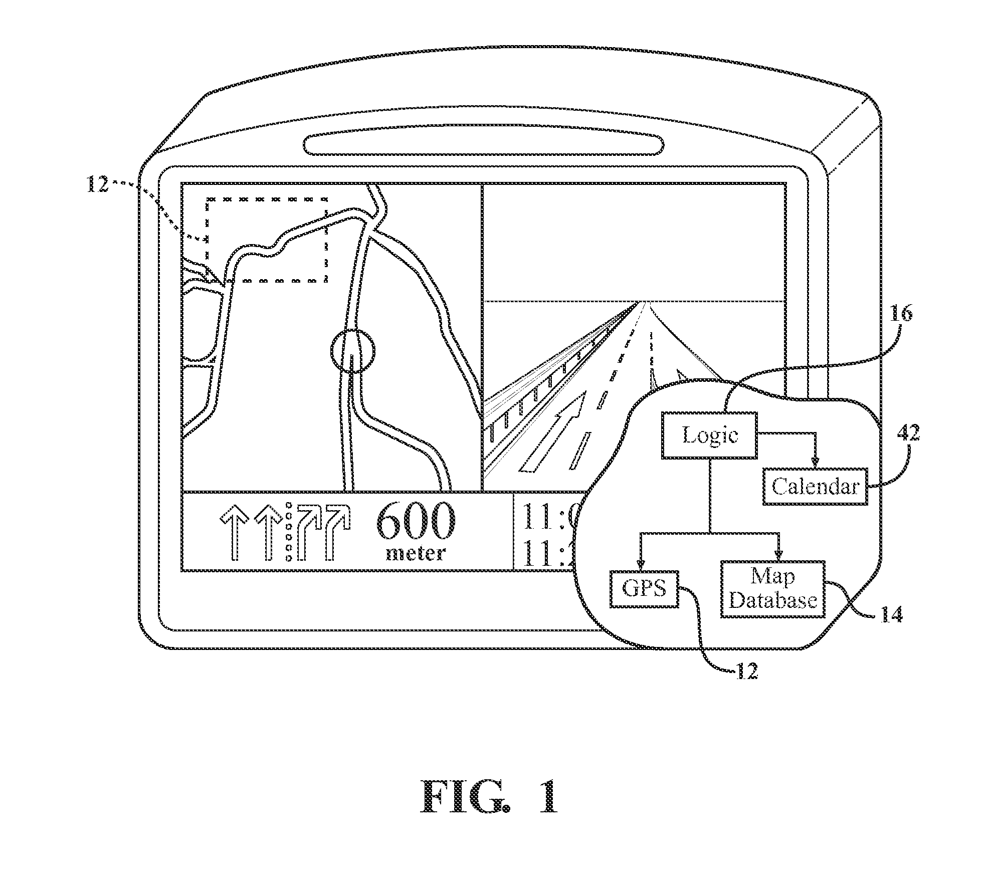
[0019]Referring now to FIG. 1, which is a navigational device 10 in accordance with the present invention. Navigational devices 10 commonly utiliz...


PUM


Abstract

A method for determining vehicle priority settings (30) at an intersection (26) is provided comprising accumulating probe data (24) from a plurality of individual navigation units (20). An intersection within a digital map (14) is selected, and a plurality of probe traces (32) are selected. The probe traces (32) are processed in a method characterized by selecting a pair of probe traces (32) that enter the intersection (26) at the same time on different trajectories (34). It is determined which of the probe traces (32) proceeds through the intersection first and an intersection priority matrix (36) is updated accordingly. This intersection priority matrix (36) is utilized to formulate at least one derived intersection priority setting (38).

Description

BACKGROUND OF THE INVENTION[0001]1. Field of the Invention[0002]This invention relates generally to a system and method for determining and validating vehicle priorities at geographical roadway intersections. More particularly, this invention relates to a method for validating vehicle priorities utilizing probe data.[0003]2. Related Art[0004]Digital maps comprise a collection of data compiled and formatted into a virtual representation of land features, related objects and services as they exist in reality. The goal of most digital map providers is to produce maps that give accurate representations of a particular area, detailing major road arteries and point features. As the detail of such digital maps, and the navigation systems that utilize them, increases the ability to verify the accuracy of these details becomes increasing difficult.[0005]A recent approach to increasing the accuracy of road location and traffic direction has been to utilize crowd sourcing. The concept of crowd...

Claims


Application Information

Patent Timeline
Patent Type & Authority Applications(United States)
IPC IPC(8): G01C21/26
CPCG01C21/26G01C21/32G01C21/3881G01C21/3815G01C21/3841
Inventor IGODT, BERT
Owner TOMTOM GLOBAL CONTENT
Why Eureka
Try Eureka