
Information processing apparatus and control method thereof

a technology of information processing apparatus and control method, applied in the field of multidimensional indexing techniques, can solve the problems of significant performance drop, inability to properly generate partial spatial regions, and index structures designed for one-dimensional data are not suitable for use in geographical information searches, etc., and achieve the effect of reducing the number of partial spatial regions

Inactive Publication Date: 2013-08-15
CANON KK
View PDF14 Cites 7 Cited by
  • Summary
  • Abstract
  • Description
  • Claims
  • Application Information

AI Technical Summary

Benefits of technology

The present invention is a way to organize data in a way that reduces empty spaces in a partial region, making it faster to search for information. This helps to make the most use of space and makes searching faster.

Problems solved by technology

For this reason, index structures designed for one-dimensional data are not suitable for use in geographical information searches.
The reason for this is that with a one-dimensional index such as a B-Tree, pieces of data in spatially close locations cannot be disposed near each other in the index, and thus a significant drop in performance can occur depending on the search query.
However, R-Trees have an issue in that the partial spatial regions cannot be properly generated depending on the laterality, registration order, and so on of the spatial data.
If empty regions increase within the partial spatial regions, it is highly likely that the search region and the partial spatial regions will overlap even if no data is present within the search region, which will result in a wasteful search process.
Accordingly, an increase in empty regions within partial spatial regions causes a drop in the search performance.
Accordingly, with the aforementioned related art, in the case where only a small number of spatial data are located at a distance from other spatial data groups, a large number of empty regions will be produced in the partial spatial regions, causing a drop in the search performance.

Method used


Image

  • Information processing apparatus and control method thereof
  • Information processing apparatus and control method thereof
  • Information processing apparatus and control method thereof

Examples


first embodiment

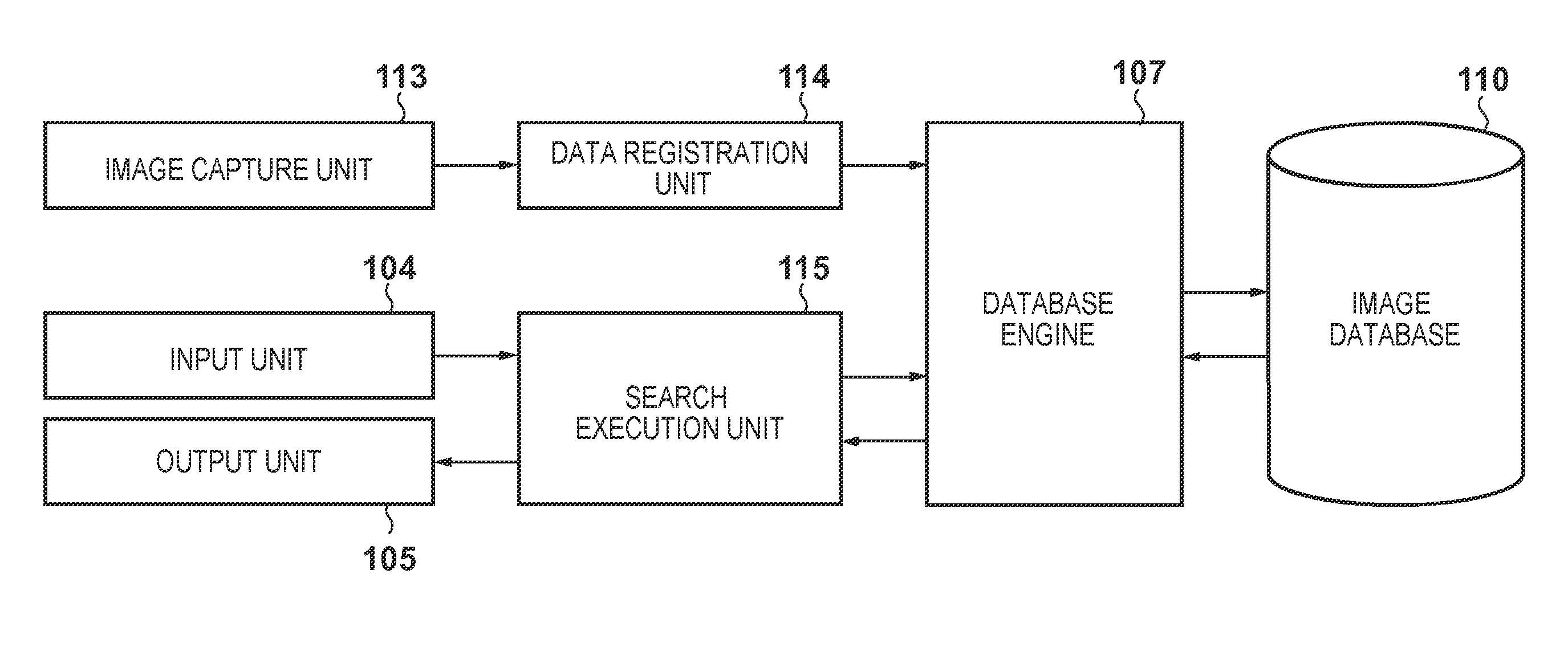
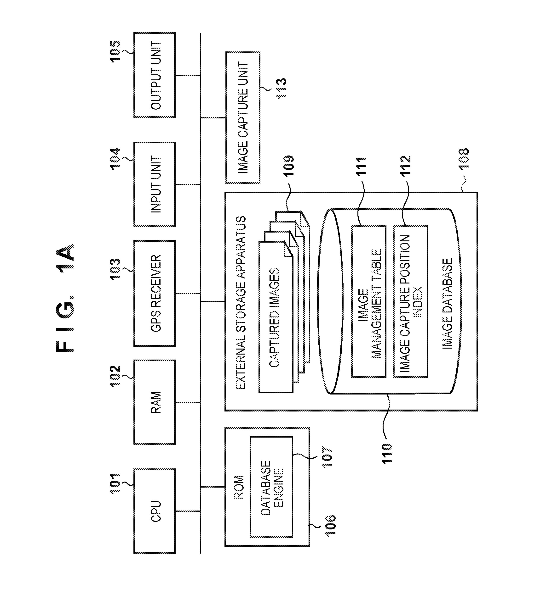
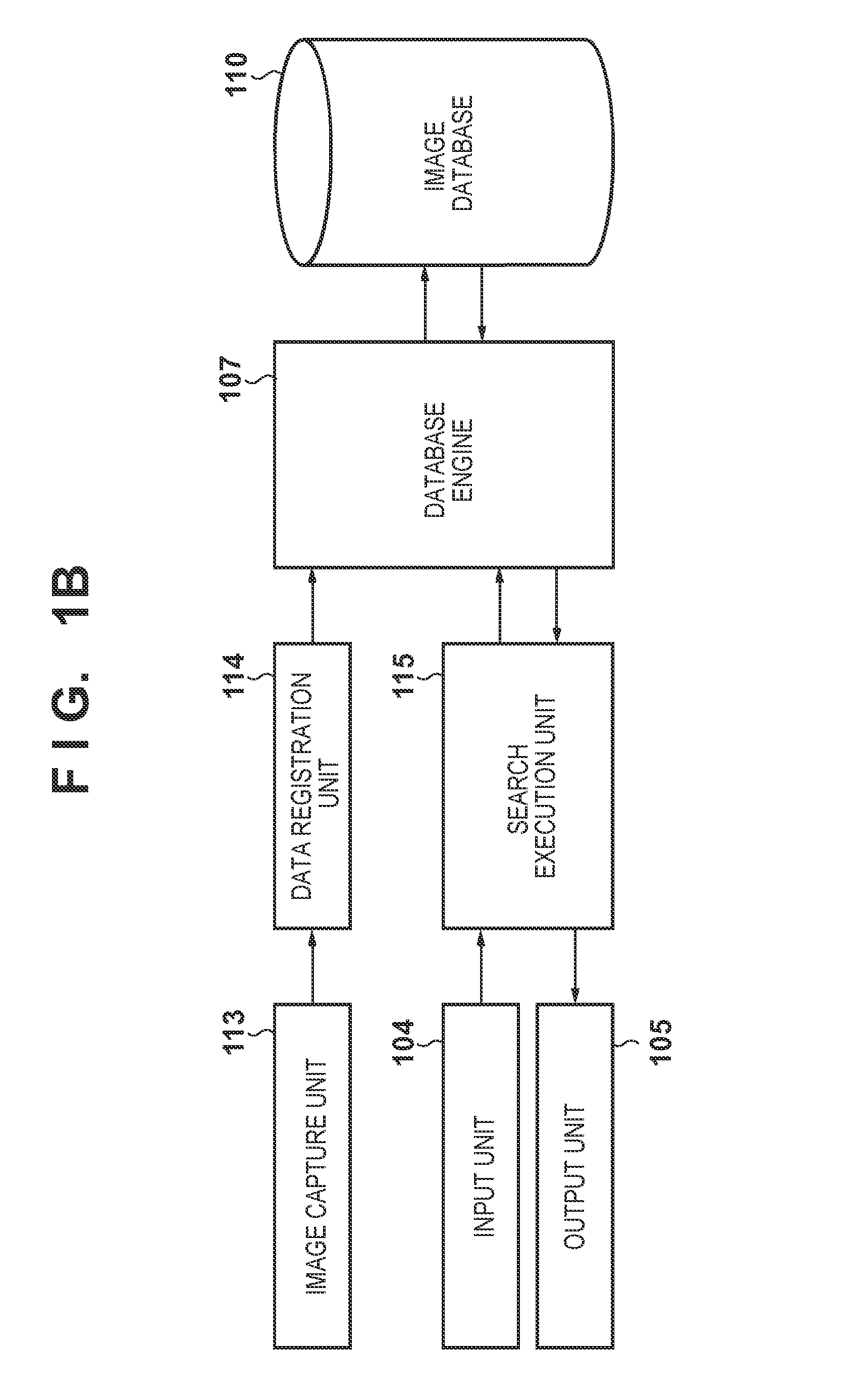
[0037]FIG. 1A is a block diagram illustrating an information processing apparatus that implements a multidimensional indexing process according to a first embodiment.

[0038]A CPU 101 controls the apparatus as a whole by executing control programs stored in a ROM 106. The ROM 106 stores programs executed by the CPU 101. By the CPU 101 executing programs, the apparatus functions as various types of constituent elements for executing various processes indicated in the flowcharts mentioned later. For example, a database engine 107 can be stored, and data can then be registered / searched. A RAM 102 temporarily stores various types of data from the various constituent elements. The RAM 102 also expands programs, which are then executed by the CPU 101.

[0039]An external storage apparatus 108 is an apparatus that stores data to be processed. A flash memory, an HDD, or the like can be used as the external storage apparatus 108. An image database 110 is present in the external storage apparatus ...

second embodiment

[0093]Hereinafter, a second embodiment of the present invention will be described. Note that descriptions of constituent elements identical to those in the first embodiment will be omitted.

[0094]The first embodiment is configured to reduce empty regions within the partial spatial region of a node by generating a new partial spatial region in the case where the enlargement value of a partial spatial region corresponding to a node within the index will be greater than or equal to a threshold.

[0095]However, in the case where photograph data is used as the spatial data, it is necessary to consider not only the capture location, but also information indicating the image capture time. For example, despite the capture locations of two pieces of photograph data being distanced from each other, in the case where the difference between image capture times is low, it can be determined that the two image capture points can be moved between in a short amount of time, and furthermore, that the us...


PUM


Abstract

Enlargement values indicating a degree of enlargement when spatial data is stored in a partial spatial region are calculated for one or more partial spatial regions within a multidimensional index, and in the case where the enlargement value is greater than or equal to a threshold value, a new partial spatial region that contains at least the spatial data is generated.

Description

BACKGROUND OF THE INVENTION[0001]1. Field of the Invention[0002]The present invention relates to multidimensional indexing techniques that speed up searches of multidimensional data such as image capture position information in photographs.[0003]2. Description of the Related Art[0004]Recent years have seen an increase in cameras that include GPS (Global Positioning System) functionality, and it has thus become possible to add geographical information, in which the latitude / longitude of the location where an image was captured is recorded, to photograph data. At the same time, photo viewing applications in cameras, PCs, and the like are increasingly being provided with functionality for using the geographical information of the capture location of photograph data to search photograph data captured within a given region and display that capture location in association with a position on the map.[0005]The geographical information of the capture location is multidimensional data configu...

Claims


Application Information

Patent Timeline
IPC IPC(8): G06F17/30
CPCG06F17/30327G06F17/30321G06F17/3028G06F17/30333G06F16/2246G06F16/51G06F16/2264G06F16/2228
Inventor UCHIDA, YUMIKO
Owner CANON KK
Learn More