
Method for updating a digital road map

Active Publication Date: 2014-02-13
KAPSCH TRAFFICCOM AG
View PDF5 Cites 11 Cited by
  • Summary
  • Abstract
  • Description
  • Claims
  • Application Information

AI Technical Summary

Benefits of technology

The patent describes a method for improving the accuracy of position readings in satellite navigation receivers. The method takes into account the mutual distances between position readings and the speed and measuring time of each reading. This allows for precise determination of consecutive position readings. Additionally, the method generates a position quality index based on the distance of the position reading from an expected value, which can be determined based on neighboring position readings or by extrapolating the expected value from preceding position readings. The use of a movement vector or a movement reading from a vehicle sensor further enhances the accuracy of the expected value. Overall, the method allows for accurate positioning without map matching and is particularly useful in real-time applications.

Problems solved by technology

Map matching methods have the drawback that the accuracy of the path length determination is limited by the segment resolution of the digital road map.
Construction sites, temporary detours and the like also cause errors in the path lengths of the vehicles determined by way of map matching.

Method used


Image

  • Method for updating a digital road map
  • Method for updating a digital road map
  • Method for updating a digital road map

Examples


Embodiment Construction

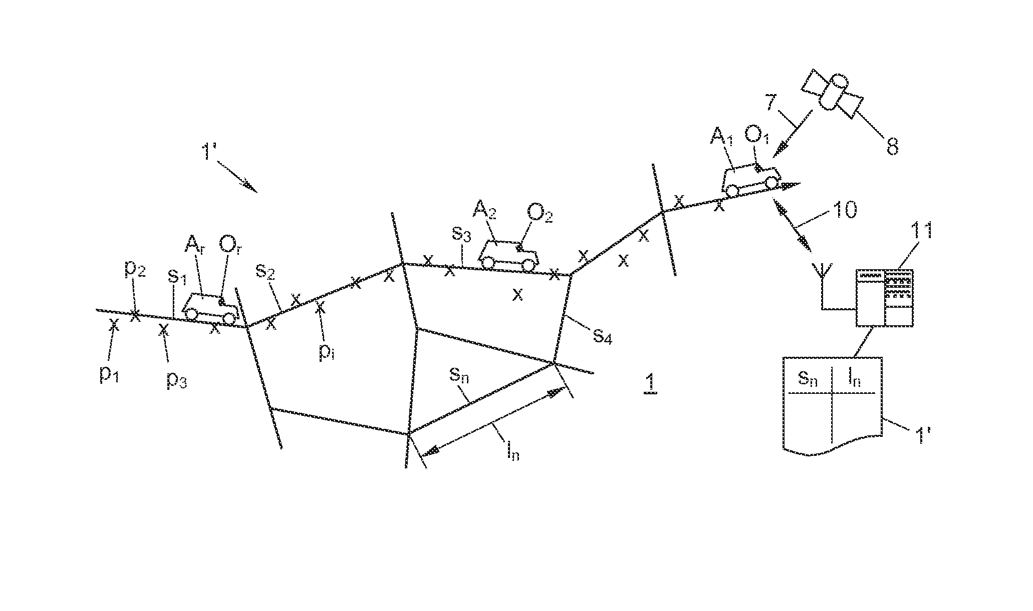
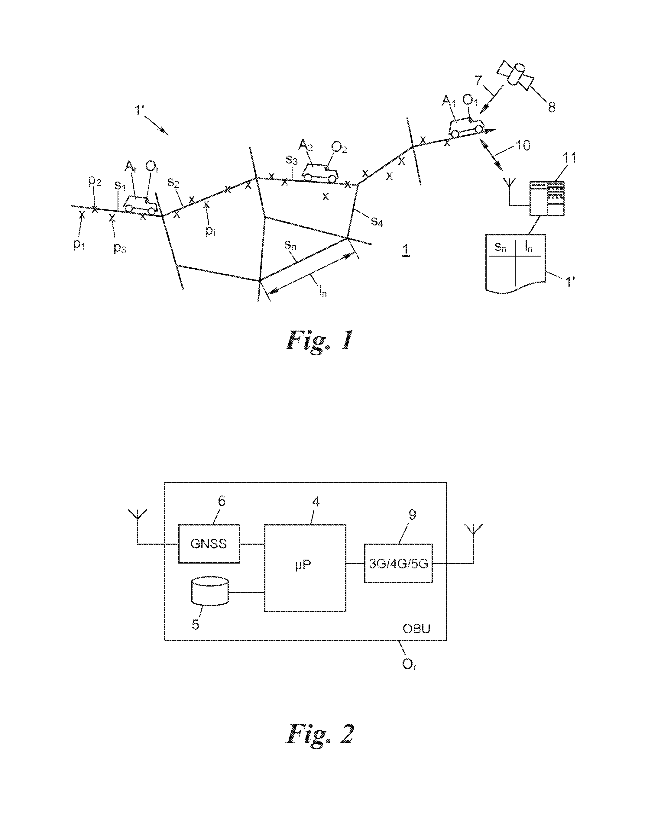
[0042]FIG. 1 shows a road system 1, which is modeled in the form of a digital road map 1′ comprising a network graph of road segments s1, s2, . . . , or in general terms sn. Several vehicles A1, A2, . . . , or in general terms Ar, which are shown by way of example, are moving about in the road system 1 and carry a respective onboard unit (OBU) O1, O2, . . . , or in general terms Or, which is capable of locating itself in the road system 1.

[0043]In addition to a microprocessor 4 and a memory 5, each OBU Or comprises a satellite navigation receiver 6 for this purpose (FIG. 2), by way of which the OBU receives navigation signals 7 of a global navigation satellite system 8 (GNSS) such as GPS (global positioning system), GLONASS (Global Navigation Satellite System), GALILEO or the like, and based thereon continually generates readings of its own position (“position fixes”) p1, p2, . . . , or in general terms pi (more precisely: pi,r; however, to simplify matters, the annexation of the OB...


PUM


Abstract

Methods are provided for updating a digital road map in which road segments having segment lengths are stored. At least two vehicles are equipped with at least one respective onboard unit generating position readings. If a first set of position readings of a first onboard unit can be associated with a road segment, a first path length is determined based on the position readings of the first set. If a second set of position readings of a second onboard unit can be associated with the road segment, a second path length is determined based on the position readings of the second set. An average path length is calculated based on at least the first and second path lengths. If the average path length deviates from the stored segment length, the average path length is stored as an updated stored segment length of this road segment in the digital road map.

Description

CROSS-REFERENCE TO RELATED APPLICATION(S)[0001]This application claims priority to European Patent Application No. 12 180 293.8, filed on Aug. 13, 2012, the entirety of which is incorporated by reference herein.BACKGROUND[0002]1. Technical Field[0003]The present application relates to a method for updating a digital road map which represents a road system and in which road segments having segment lengths are stored.[0004]2. Background Art[0005]Digital road maps are required in road toll systems, for example, which are based on a map matching process. In such systems, vehicles carry onboard units (OBUs), which continually generate readings of their own positions, so as to compare these to the digital road map and determine the respective nearest road segments as having been driven. The segment lengths of the driven road segments are then added so as to calculate and thereafter impose tolls on the length of the path traveled by the vehicle.[0006]So as to generate the position readings...

Claims


Application Information

Patent Timeline
IPC IPC(8): G01C21/34
CPCG01C21/34G01C21/30G01C21/3841G01C21/3819G01C21/3844G01C21/3815
Inventor TIJINK, JASJASCHEIDER, THOMASWEIMANN, FRANZSCHRODL, SOREN
Owner KAPSCH TRAFFICCOM AG
Learn More