Methods and systems for colorizing an enhanced image during alert

Inactive Publication Date: 2014-09-25
HONEYWELL INT INC
View PDF4 Cites 19 Cited by
  • Summary
  • Abstract
  • Description
  • Claims
  • Application Information

AI Technical Summary

Benefits of technology

[0007]The present invention appropriately colors a threat on all terrain viewed in a combined vision system (CVS). By coloring the sensor image, an intui

Problems solved by technology

The integrity of the synthetic terrain display is limited by the integrity of t

Method used


Image

  • Methods and systems for colorizing an enhanced image during alert
  • Methods and systems for colorizing an enhanced image during alert
  • Methods and systems for colorizing an enhanced image during alert

Examples


Embodiment Construction

[0012]The following detailed description is merely exemplary in nature and is not intended to limit the subject matter of the application and uses thereof. Furthermore, there is no intention to be bound by any theory presented in the preceding background or the following detailed description.

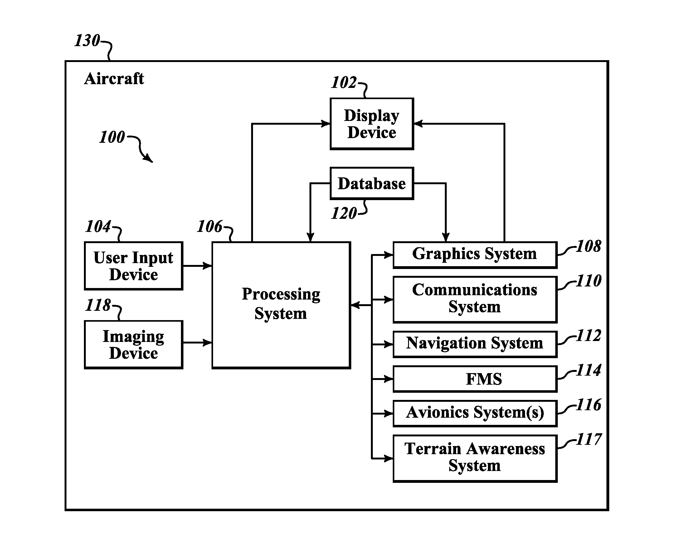
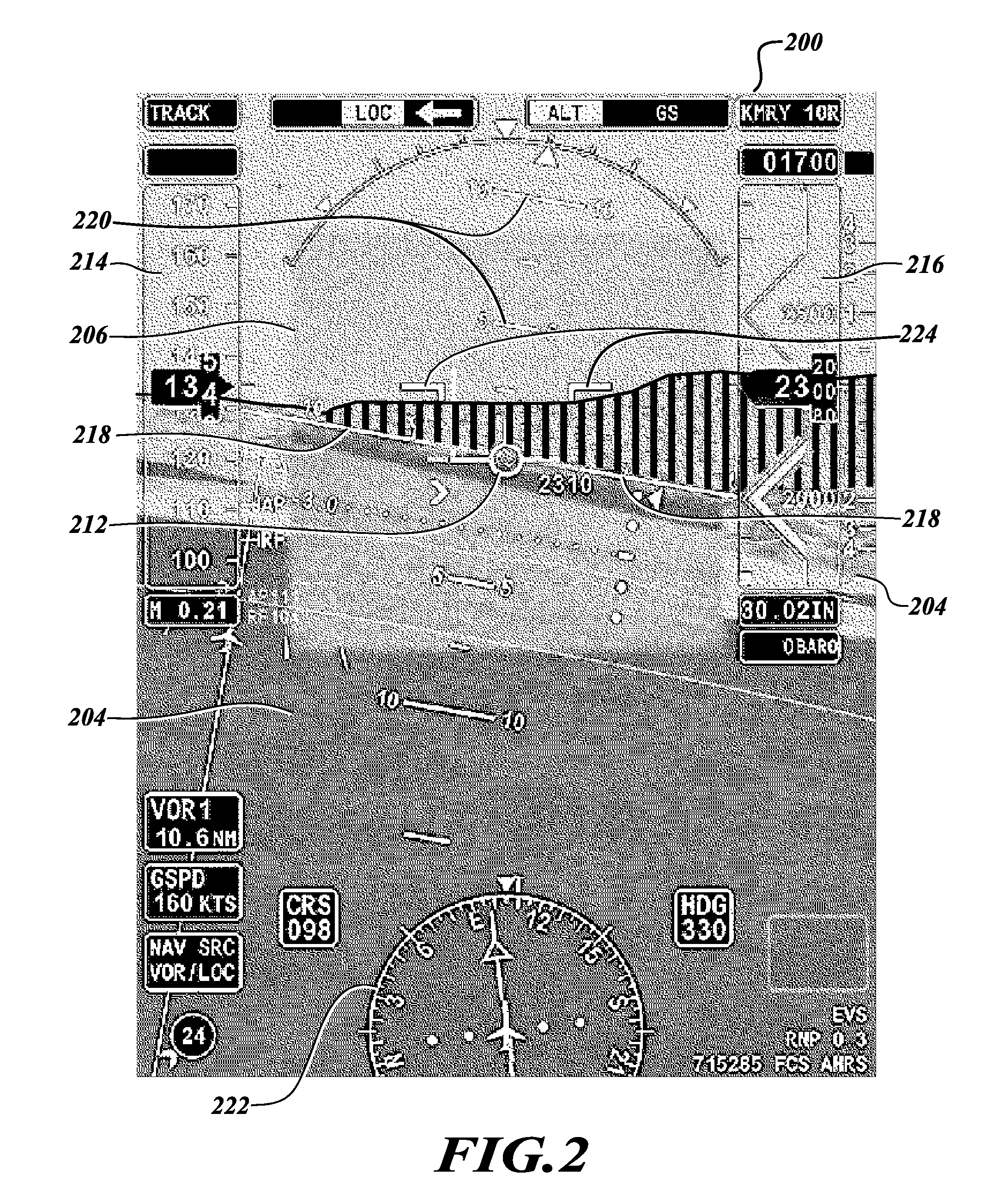
[0013]Technologies and concepts discussed herein relate to systems for visually partitioning real-time images received from an imaging device onboard a vehicle, such as an aircraft, to enhance the ability of a user (e.g., a pilot or crew member) to quickly and accurately determine the relative altitude and / or attitude or alerts of the features shown in the real-time images. The real-time images are partitioned using distinguishable characteristics, such as, for example, visually distinguishable colors or levels of transparency, to allow a pilot or crew member to intuitively identify the relative altitude and / or attitude or alert conditions of the respective portions of an image. Additionally, th...


PUM


Abstract

Methods and systems for improving presentation of terrain/obstacle alerting information in a composite (synthetic and sensor) image. An exemplary system includes an imaging device that obtains image data for a region exterior to the vehicle, a processing system, and a display device. The processing system is in data communication with the display device and the imaging device. The processing system receives information from an alerting (e.g., a terrain awareness and warning) system and the obtained image data, colors, or makes transparent at least a portion of the obtained image data, if the received information indicates that an alert condition exists for the portion of the obtained image data, and generates a composite image comprising a previously generated synthetic image and the obtained image data with the enhanced portion. The display device displays the composite image. The obtained image data overlie the synthetic image.

Description

BACKGROUND OF THE INVENTION[0001]Modern flightdeck displays (or cockpit displays) for vehicles (such as an aircraft) convey a considerable amount of information, such as vehicle position, speed, altitude, attitude, navigation, target, and terrain information. In the case of an aircraft, most modern displays additionally show a flight plan from different views, either a lateral view, a vertical view, or a perspective view, which can be displayed individually or simultaneously on the same display. The perspective view provides a three-dimensional view of the vehicle's flight plan (or vehicle's forward path) and may include various map features including, for example, weather information, terrain information, political boundaries, and navigation aids (e.g., waypoint symbols, line segments that interconnect the waypoint symbols, and range rings). The terrain information may include situational awareness (SA) terrain, as well as terrain cautions and warnings, which, among other things, m...

Claims


Application Information

Patent Timeline
IPC IPC(8): G08B13/196
CPCG08B13/196G08G5/0013G08G5/0021G08G5/0026G08G5/0086G02B2027/0138G02B27/01G02B2027/014G01C23/00
Inventor FEYEREISEN, THEA L.HE, GANGSUDDRETH, JOHN G.
Owner HONEYWELL INT INC
Why Eureka
Try Eureka