System and method for creating, storing, and updating local dynamic MAP database with safety attribute

a dynamic map and database technology, applied in the field of system and method for creating, storing and updating local dynamic map database with safety attribute, can solve the problems of high required number of maps, inability to manage, and inherently made mistakes by drivers

Active Publication Date: 2014-12-04
HARMAN INT IND INC
View PDF9 Cites 100 Cited by
  • Summary
  • Abstract
  • Description
  • Claims
  • Application Information

AI Technical Summary

Problems solved by technology

People inherently make a lot of mistakes during driving (and cause accidents), due to the lack of sleep, various distractions, talking to others in the vehicle, fast driving, long driving, heavy traffic, rain, snow, fog, ice, or too much drinking.
Given the number of signalized intersections in United States (around 0.3 Million) and many more across the globe, the required number of MAPs required are very high, and thus, very hard to manage.
Lane level maps are required for most of these applications which is currently not available.
As this very approach of updating is time consuming, and given the number of MAPs and the frequency of changes, creating and maintaining these MAPs would be a real challenge.
However, none of the prior art teaches the features shown in this current disclosure, as detailed below.

Method used


Image

  • System and method for creating, storing, and updating local dynamic MAP database with safety attribute
  • System and method for creating, storing, and updating local dynamic MAP database with safety attribute
  • System and method for creating, storing, and updating local dynamic MAP database with safety attribute

Examples


case 1

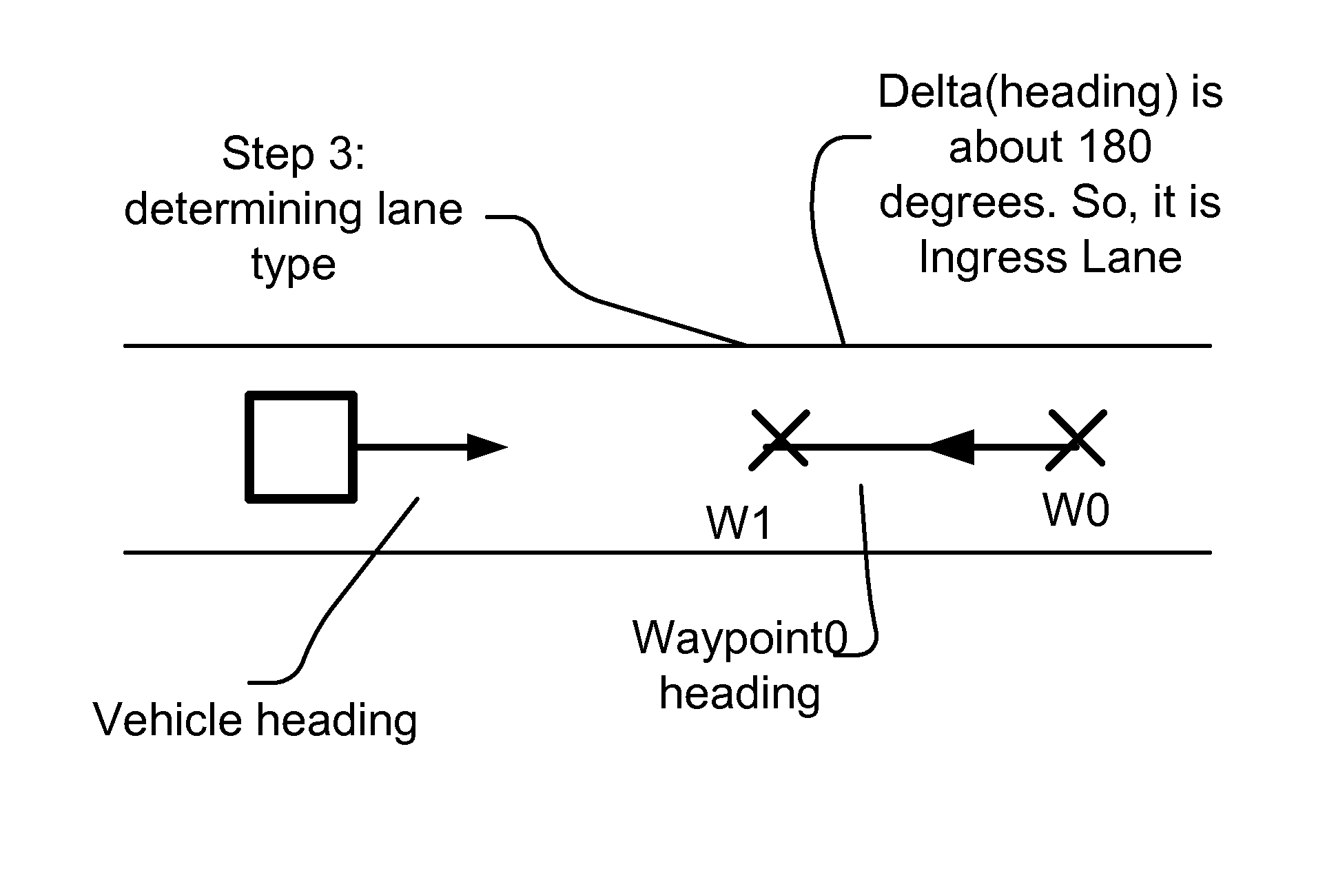
[0203] No Base map is available (initial condition):[0204]For a Look-aside MAP, once the MAP has sufficient number of vehicle (say e.g. 100) traversals on each of its lanes, consider it for further calculations.[0205]Once the above limit is reached, execute a Map-matching of vehicles with Look-aside MAP, and determine the match percentage or ratio. Average the matching percentage for all the vehicles.[0206]If the Match-percentage is high (say e.g. above 99%), upgrade the Look-aside database at that instant to Base-MAP.

case 2

[0207] Base Map is available (updating condition):[0208]Compare the Base Map with Look-aside MAP for following differences:[0209]Lateral distance shifts in the Waypoints of the lane: Ignore them if the shift is less than Ds, e.g. 20 cm, or a threshold distance.[0210]In one embodiment, Ds is defined e.g. based on lane width or average vehicle length or width, or based on D. For example, Ds is set equal to D.[0211]In one embodiment, Ds is adjusted based on historical data, or corrected by human expert periodically.[0212]Connection lane changes: Changes in possible maneuver codes of the lane and the connected lane lists.[0213]Change in Signal-Phase matching.[0214]In case the changes in the Base-Map and Look-aside Map are considerable (above a threshold), and base Map is failing to provide high-Map-matching results, while Look-aside MAP is able to provide high MAP-Matching results, consider upgrading Look-aside MAP in the following criteria:[0215]Manual override is detected for upgradin...


PUM


Abstract

DSRC (Dedicated short range communication) is expected to play a significant role in Transportation applications for Public Safety and Traffic Management. Some of the key applications especially safety and mobility application requires an accurate representation of the road segments. Accordingly, here, in one example, we describe a method and infrastructure for DSRC V2X (vehicle to infrastructure plus vehicle) system. This presentation, e.g., adds the following improvements on the existing technologies, as some of the examples: (a) Using Speed-Profiles for identifying Intersections/mandatory-stops/Speed-limits, etc. Also, the extension of the map coverage using speed profile data. (b) Vehicular density identification for determining confidence of generated MAP. (c) Mechanisms for identifying Lane Attributes, like Lane-Width, Lane-Connections, Possible Movement states, average travel-time on the lane, etc. In this presentation, we provide various methods and systems to manage and update such maps and its corresponding information, plus many variations on those.

Description

RELATED APPLICATIONS[0001]This application is a CIP of co-pending another US utility application, namely, Ser. No. 14 / 047,157, titled “System and method for map matching”, filed Oct. 7, 2013 which in turn is a CIP of two other co-pending US utility applications, namely, Ser. No. 13 / 907,864, titled “System and method for lane boundary estimation and host vehicle position and orientation”, filed Jun. 1, 2013, and Ser. No. 13 / 907,862, titled “System and method for node adaptive filtering and congestion control for safety and mobility applications toward automated vehicles system”, filed Jun. 1, 2013. It is also related to another US patent application filed on about the same day, with docket number Savari-4, with the same inventors and assignee, titled “System and method for road side equipment of interest selection for active safety applications”. The teachings of all the above applications are incorporated herein, by reference. The current application claims the priority date of the ...

Claims


Application Information

Patent Timeline
Patent Type & Authority Applications(United States)
IPC IPC(8): G08G1/00
CPCG08G1/00G08G1/0112G08G1/0129G08G1/0141G06F16/29G01C21/3867G01C21/10G01C21/26G01C21/367G08G1/096791B60W2556/50
Inventor IBRAHIM, FAROOGSAGAR, KATTA VIDYA
Owner HARMAN INT IND INC
Why Eureka
Try Eureka