Three-dimensional positioning method

a three-dimensional positioning and positioning method technology, applied in the field of three-dimensional positioning system, can solve the problems of disadvantageous weather affecting the use of images, prior art cannot meet the needs of users in actual use of integrating optical images, etc., and achieve the effect of improving shortcomings

Inactive Publication Date: 2016-09-08
NAT CENT UNIV
View PDF4 Cites 21 Cited by
  • Summary
  • Abstract
  • Description
  • Claims
  • Application Information

AI Technical Summary

Benefits of technology

[0008]Embodiments provide a three-dimensional positioning system with integration of radar AND optical satellite images and effectively improves the shortcomings of the prior art. Directional information in optical imag

Problems solved by technology

However, for optical images, weather disadvantageously affects whether the images can be used or not.
Therefore, the prior art

Method used


Image

  • Three-dimensional positioning method
  • Three-dimensional positioning method
  • Three-dimensional positioning method

Examples


Embodiment Construction

[0056]The aforementioned illustrations and following detailed description are exemplary for the purpose of further explaining certain embodiments. It should be understood that the figures are schematic in nature and should not be understood as being to scale or illustrating exactly a particular implementation of aspects of embodiments. Other objectives and advantages will be illustrated in the subsequent descriptions and appended tables.

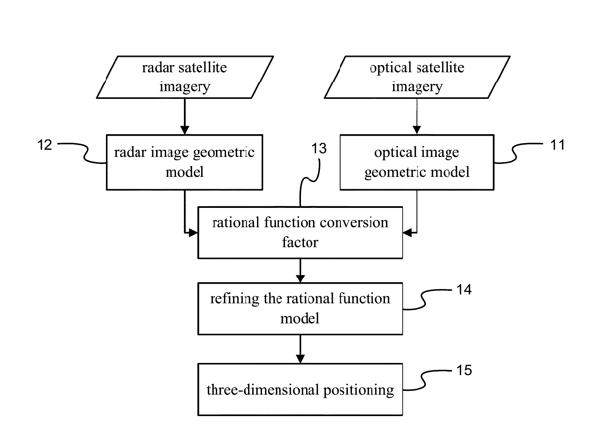
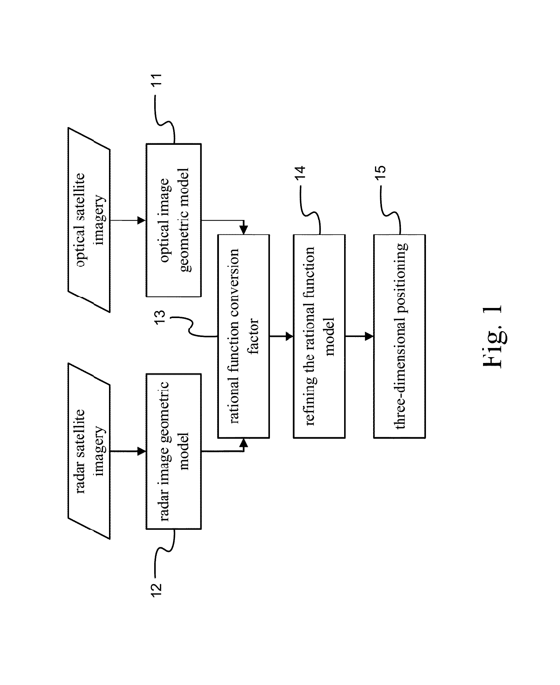
[0057]Surface three-dimensional information is essential to environmental monitoring and conservation of soil and water resources. Synthetic aperture radar (SAR) and optical imaging offer telemetry data useful for obtaining three-dimensional information. Integration of information from both optical AND radar sensors provides even more useful information. Please refer to FIG. 1 which is a flow chart of three-dimensional positioning by integrating radar AND optical satellite imagery according to one embodiment. FIG. 1 shows three-dimensional positionin...


PUM


Abstract

A three-dimensional positioning system includes establishing a geometric model for optical AND radar sensors, obtaining rational function conversion coefficients, refining the rational function model and positioning three-dimensional coordinates. The system calculates rational polynomial coefficients from a geometric model of optical AND radar sensors, followed by refining a rational function model by determined ground control points and object image space intersection. The system then measures one or more conjugate points on the optical and radar images. Finally, an observation equation is established by the rational function model to solve and display three-dimensional coordinates.

Description

RELATED APPLICATIONS[0001]This application is a continuation-in-part of U.S. application Ser. No. 13 / 869,451 filed Apr. 24, 2013 entitled “Three-Dimensional Positioning Method” and claims the priority of Taiwanese application 102100360 filed Jan. 4, 2013.BACKGROUND OF THE INVENTION[0002]1. Field of the Invention[0003]Embodiments relate to a three-dimensional positioning system, more particularly to a three-dimensional positioning system applicable to multiple satellite images in a satellite positioning system. More particularly, a three-dimensional positioning system uses a rational function model (RFM) with integration of optical data and radar data.[0004]2. Description of Related Art[0005]Common information sources for surface stereo information from satellite images are acquired by using optical images OR radar images. For optical satellite images, the most common method is to use three-dimensional image pairs. For example, Gugan et al. have proposed accurate topographic mapping ...

Claims


Application Information

Patent Timeline
IPC IPC(8): G01S13/86G06T7/00G01S13/90G06V20/13
CPCG01S13/867G01S13/90G06T7/0046B64G2001/1028G06T2207/10028G06T2207/10044G06T2207/30181G06T2207/20221B64G2001/1035G01C21/005G06T2207/10036G06T7/55G01S13/9027G06V20/13B64G1/1035B64G1/1028
Inventor CHEN, LIANG-CHIENYANG, CHIN-JUNG
Owner NAT CENT UNIV
Why Eureka
Try Eureka