System and Method for Hybrid Simultaneous Localization and Mapping of 2D and 3D Data Acquired by Sensors from a 3D Scene

Active Publication Date: 2017-06-08
MITSUBISHI ELECTRIC RES LAB INC
View PDF13 Cites 15 Cited by
  • Summary
  • Abstract
  • Description
  • Claims
  • Application Information

AI Technical Summary

Benefits of technology

[0012]Then, point-to-point, line-to-point, and line-to-line correspondences are determined. For the line-to-point correspondences, we use the 3D lines associated by the 2D point features to “pinpoint” the corresponding 3D point features, and to generate longer-range constraints than using only point-to-point correspondences. For the line-to-line correspondences, the 3D lines are triangulated to generate 3D points that are used as 3D point features in the subsequent processing. Herein, 3D lines and 2D points are used interchangably as they both refer to the keypoints with

Problems solved by technology

Conventional SLAM systems with an RGB-D sensor use depths only for a limited range due to hardware limitation and no

Method used


Image

  • System and Method for Hybrid Simultaneous Localization and Mapping of 2D and 3D Data Acquired by Sensors from a 3D Scene
  • System and Method for Hybrid Simultaneous Localization and Mapping of 2D and 3D Data Acquired by Sensors from a 3D Scene
  • System and Method for Hybrid Simultaneous Localization and Mapping of 2D and 3D Data Acquired by Sensors from a 3D Scene

Examples


Embodiment Construction

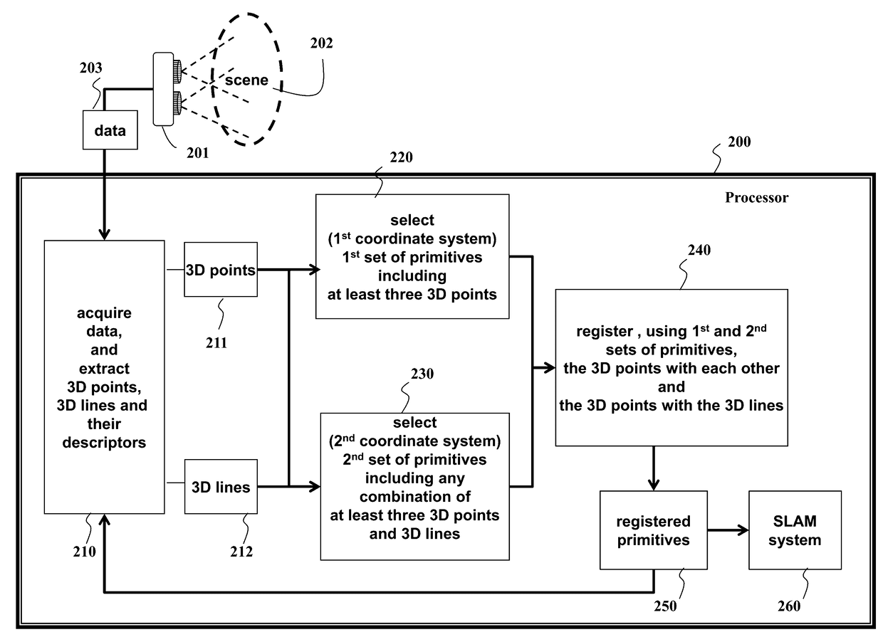
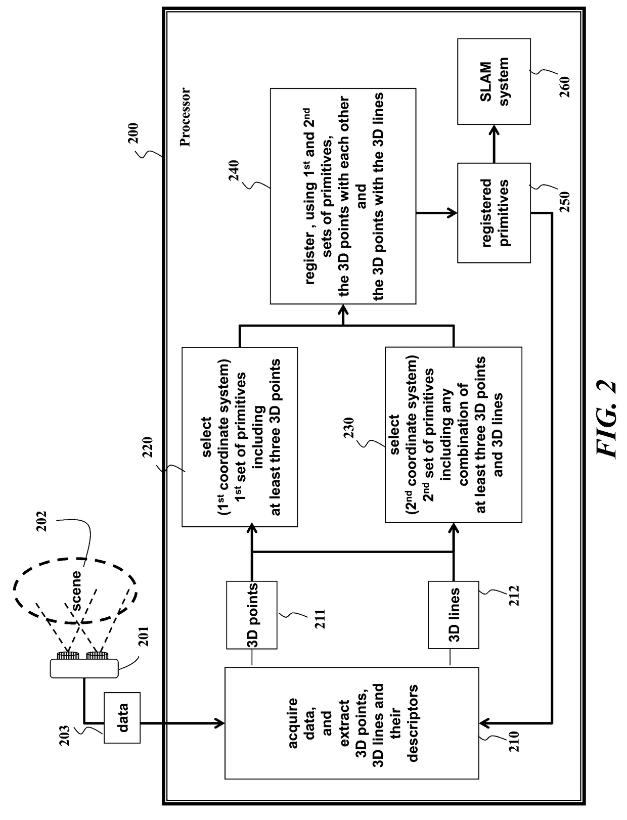
[0018]The embodiments of the invention provide a system and method for hybrid simultaneous localization and mapping of 2D and 3D data acquired by a red, green, blue, and depth (RGB-D) sensor.

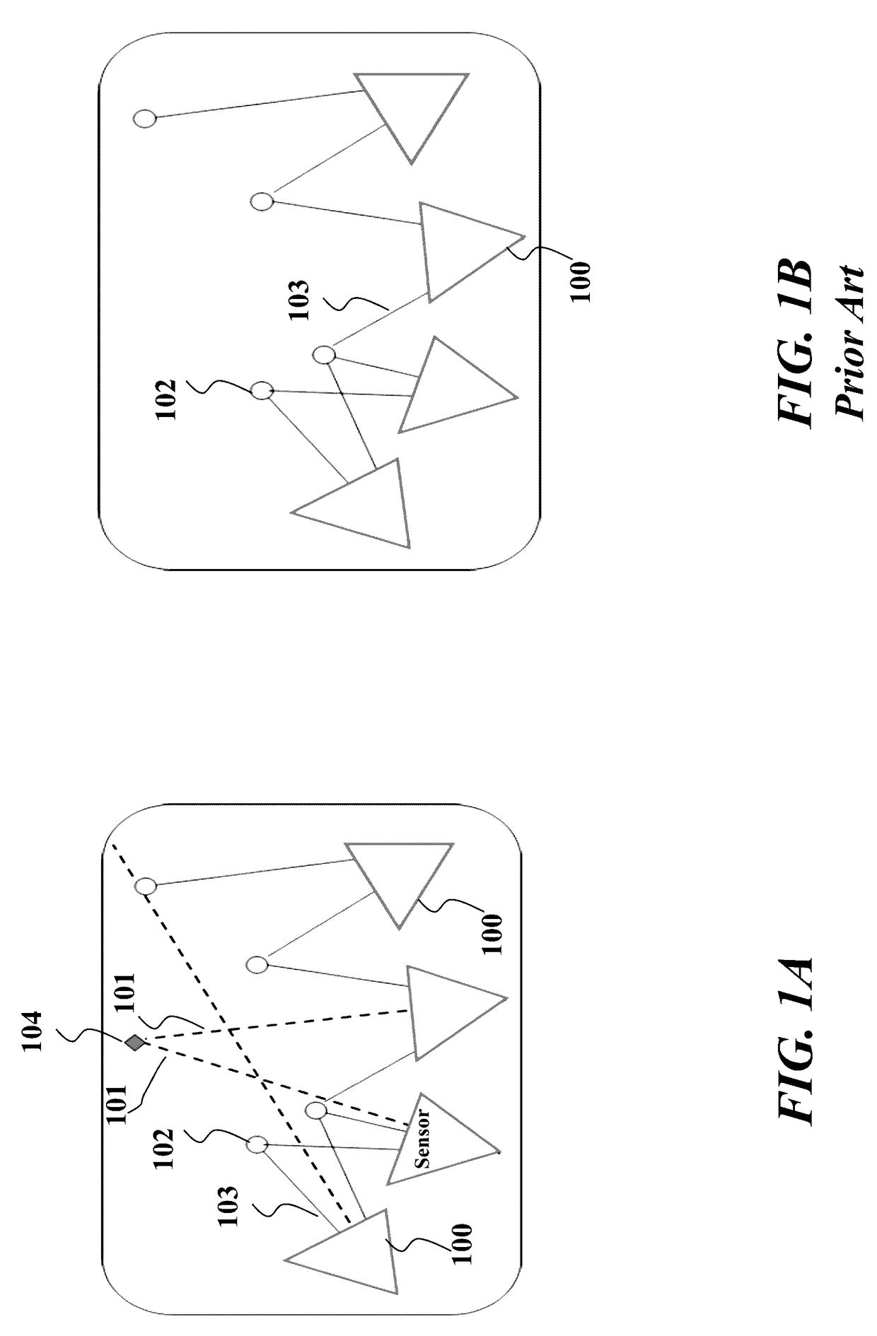
[0019]FIG. 1A schematically shows the key idea of “pinpointing” 3D points from 2D points used by embodiments of our invention. Triangles 100 represent a sensor at different poses (viewpoints), i.e., different 3D positions and 3D orientations. Alternatively, multiple sensors can be used.

[0020]Dashed lines 101 represent the lines associated with 2D measurements (i.e., 2D keypoints with invalid depths), and circles 102 and solid lines 103 represent 3D measurements. Triangulated 3D points are shown with diamonds 104. The triangulation uses the intersection of the lines 101. In addition to point-to-point correspondences that are used in a conventional SLAM system, we use line-to-point and line-to-line correspondences to generate long-range constraints. The lines defined by the 2D points (keypoints wi...


PUM


Abstract

A method and system for registering data by first acquiring the data from a scene by a sensor at different viewpoints, and extracting, from the data, three-dimensional (3D) points and 3D lines, and descriptors associated with the 3D points and the 3D lines. A first set of primitives represented in a first coordinate system of the sensor is selected, wherein the first set of primitives includes at least three 3D points. A second set of primitives represented in a second coordinate system is selected, wherein the second set of primitives includes any combination of 3D points and 3D lines to obtain at least three primitives. Then, using the first set of primitives and the second set of primitives, the 3D points are registered with each other, and the 3D points with the 3D lines to obtain registered primitives, wherein the registered primitives are used in a simultaneous localization and mapping (SLAM) system.

Description

RELATED APPLICATION[0001]This U.S. Non-Provisional Application is related to U.S. Non-Provisional application Ser. No. 14 / 962,239, co-filed herein with and incorporated herein by reference. That Application discloses a method and system for detecting and tracking objects using a red, green, blue, and depth (RGB-D) data acquired by an RGB-D sensor using simultaneous localization and mapping (SLAM) and hierarchical feature grouping.FIELD OF INVENTION[0002]This invention relates to registering two-dimensional (2D) and three-dimensional (3D) data, and more particularly to registering 2D and 3D data obtained from an RGB-D sensor for sensor pose estimation, and computer vision applications such as 3D scene reconstruction, robotics, and augmented reality.BACKGROUND OF THE INVENTION[0003]Simultaneous localization and mapping (SLAM) is used for many applications in computer vision, robotics, and augmented reality. An essential part of SLAM system is sensor localization. This involves registr...

Claims


Application Information

Patent Timeline
IPC IPC(8): G06T7/00H04N13/02G06K9/46
CPCG06T7/0028G06T7/0075G06K9/46G06T2200/04G06T2207/10012G06T2207/10028H04N13/0207G06T7/33G06T7/593H04N13/207G06T7/344
Inventor CANSIZOGLU, ESRATAGUCHI, YUICHIRAMALINGAM, SRIKUMAR
Owner MITSUBISHI ELECTRIC RES LAB INC
Why Eureka
Try Eureka