Determining the position of a mobile device in a geographical area

a mobile device and geographical area technology, applied in the direction of distance measurement, navigation instruments, instruments, etc., can solve the problems of affecting the performance of the mobile device, the state of the art approaches cannot handle a limited number of phone placement options, and the generality and robustness of existing solutions, so as to improve the performance of any pdr implementation, robust to user, device and phone placement variability

Active Publication Date: 2017-08-24
OXFORD UNIV INNOVATION LTD
View PDF2 Cites 30 Cited by
  • Summary
  • Abstract
  • Description
  • Claims
  • Application Information

AI Technical Summary

Benefits of technology

[0046]Robustness: It uses a phone placement classification scheme that is simple, yet comprehensive, i.e. covers all possible ways of attaching the phone to the human body. Based on this scheme, it provides what is called here “R-PDR”, a robust pedestrian dead reckoning (PDR) algorithm that is based on general physics principles underpinning human motion, and avoids using context-specific heuristics, such as if phone is in a pant (or “trouser”) pocket, use technique A; else if in text mode, use technique B. By design, R-PDR aims to be robust to user, device and phone placement variability.
[0047]Lifelong learning: While PDR parameters often require context-specific tuning, in the present invention this information is learnt, rather than being manually tuned or assumed as an initial input. To this end, it uses an interplay between the pedestrian dead reckoning (PDR) and map-matching (MM) layers. Existing work typically feeds PDR output into a map matching technique (e.g. particle filter / HMM / CRF), which exploits map information to correct the inertial trajectory. A part of the invention, which named herein Lifelong Learning Tracker (LL-Tracker) introduces a reverse link between the two layers. It augments the functionality of the map-matching layer to learn context-specific parameters, which are then fed back to the underlying PDR layer. The efficacy of LL-Tracker in learning parameters of the present robust pedestrian dead reckoning algorithm (R-PDR) is demonstrated, however lifelong learning is broadly applicable to improve the performance of any PDR implementation that requires parameter tuning.

Problems solved by technology

Inertial tracking, or “dead reckoning”, with or without the aid of existing maps, has received a lot of attention recently, but existing solutions lack generality and robustness.
When tested in different conditions from the ones designed for, their performance degrades significantly.
However, even the state of the art approaches can only handle a limited number of phone placement options.
When the user deviates from this predefined set, the tracking system is at a loss for how to handle the new case.
Another major issue is that the inertial tracking system typically assumes knowledge of a number of parameters that account for user, device and environment variability.
The vast tuning effort involved in optimizing pedestrian dead reckoning (PDR) systems is one of the major hurdles that prevent inertial tracking systems from becoming mainstream.

Method used


Image

  • Determining the position of a mobile device in a geographical area
  • Determining the position of a mobile device in a geographical area
  • Determining the position of a mobile device in a geographical area

Examples


Embodiment Construction

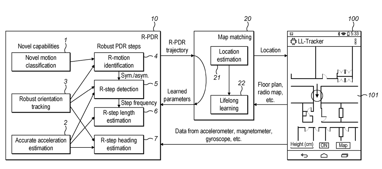
[0081]FIG. 1 shows the system architecture in an embodiment of the invention.

[0082]A smart phone 100 having sensors, such as an accelerometer, magnetometer, gyroscope, etc. is provided with software, the modules of which are shown in the rest of the Figure. The accelerometer, magnetometer and gyroscope are the main sensors but others could be taken into account by the system to provide position, acceleration and orientation signals, such as a barometer, light sensors and so on.

[0083]A first layer of the software, a Robust Pedestrian Dead Reckoning (R-PDR) 10, is equipped with three novel modules: Firstly, it features a novel motion classification scheme 1, which uses only two classes in its classification, but nonetheless captures a wide spectrum of human motion and device placement combinations. Secondly, leveraging simple observations about human motion, R-PDR has an acceleration estimate module 2 with a robust mechanism for correcting short-term and long-term acceleration bias. T...


PUM


Abstract

A mobile device (100) caried by a user has sensors providing acceleration and orientation information. These are processed to provide trajectory for the device. The processing includes improved methods using different modules (1, 2, 3,5, 6, 7) for classifying the motion (1) and detecting a user's steps (5), tracking the orientation (3) and acceleration (2) of the device (100), estimating the length of the user's steps (6) and estimating the heading (7) of the user. The trajectories are compared to a map and corrected by the constraints provided by the map. Parameters of the methods of producing the trajectories are optimised on the basis of maximising probability of the trajectory found by the map matching given the indicated trajectory.

Description

FIELD OF THE INVENTION[0001]The present invention relates to methods and devices related to determining the position of a mobile device in a geographical area. The invention is particularly applicable where the geographical area is an indoor area. More particularly, but not exclusively it relates to improved methods of processing data from orientation and acceleration sensors.BACKGROUND[0002]Indoor tracking and navigation is a fundamental need for pervasive and context-aware smartphone applications. Applications of indoor positioning include smart retail, navigation through large public spaces like transport hubs, and assisted living. The ultimate objective of indoor positioning systems is to provide continuous, reliable and accurate positioning on smartphone class devices. Inertial tracking, or “dead reckoning”, with or without the aid of existing maps, has received a lot of attention recently, but existing solutions lack generality and robustness. They are typically targeted at ac...

Claims


Application Information

Patent Timeline
Patent Type & Authority Applications(United States)
IPC IPC(8): G01C21/20G01C21/12
CPCG01C21/12G01C21/206G01C21/16G01C22/006
Inventor TRIGONI, AGATHONIKIXIAO, ZHUOLING
Owner OXFORD UNIV INNOVATION LTD
Why Eureka
Try Eureka