
Method for analyzing the types of water sources based on natural geographical features

a technology of natural geographical features and water sources, applied in the field of methods for analyzing the types of water sources based on natural geographical features, can solve the problem of less studies for examining

Inactive Publication Date: 2018-03-01
CHINA INST OF WATER RESOURCES & HYDROPOWER RES
View PDF1 Cites 71 Cited by
  • Summary
  • Abstract
  • Description
  • Claims
  • Application Information

AI Technical Summary

Benefits of technology

The present invention is a method for analyzing different types of water sources based on their natural geographical features. By processing data on vegetation and landform factors, the method can identify the different landform zones and the types of water sources that are suitable for plant growth in each zone. The method also considers the precipitation patterns and the distance between different landform zones and water sources to determine the types of water sources in a target area. The invention allows for a more comprehensive analysis and zoning of water sources based on their natural geographical features, which can be useful in ecological barrier construction, water resource protection, and climate change response.

Problems solved by technology

However, the types and constituents of water sources have basic characteristic drawbacks, namely “three-more and three-less”, which is as follows: firstly, “more watercourses and less slopes”, namely more work for analyzing the water sources of different rivers or transection of reservoirs, but less studies for analyzing the constituents of water sources of different slope units; secondly, “more states and less processes”, namely more studies for certain periods or certain time nodes, but less work for the evolution process of important types of water sources and the comprehensive influence for water circulation thereof; thirdly, “more analyses and less examinations”, namely more work for analyzing the constituents of water sources by a single method, but less studies for examining the scientificity and reliability of analyzing result by multiple methods.

Method used


Image

  • Method for analyzing the types of water sources based on natural geographical features
  • Method for analyzing the types of water sources based on natural geographical features
  • Method for analyzing the types of water sources based on natural geographical features

Examples


Embodiment Construction

[0025]Hereinafter, the technical solution in an embodiment of the present invention is clearly and fully described with reference to the drawings in the embodiment of the present invention. Apparently, the described embodiment is only one embodiment of the present invention. Based on the embodiment of the present invention, all the other embodiments that can be obtained without any creative efforts of those of ordinary skill in the art fall into the protection scope of the present invention.

[0026]For simplicity, things known to those of ordinary skill in the art are omitted in the following contents.

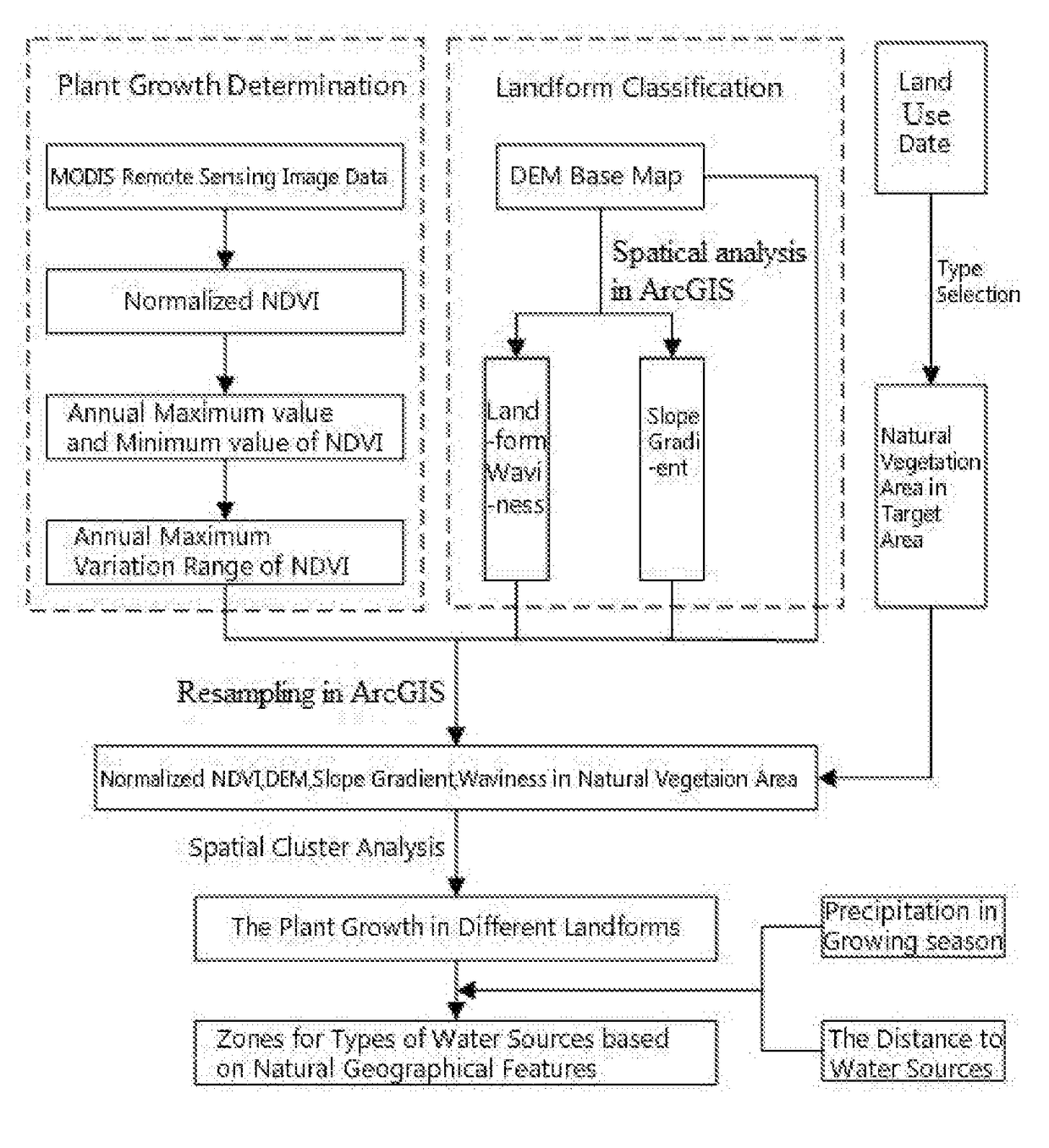
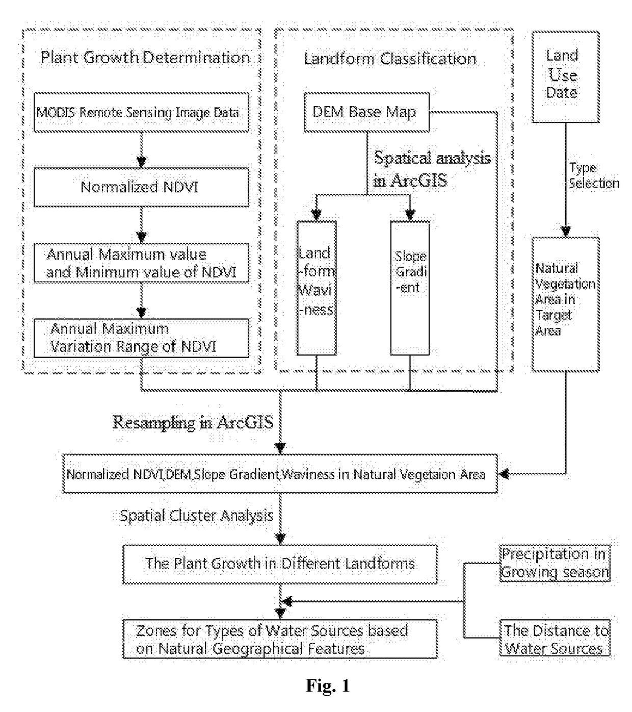
[0027]As shown in FIGURE, the method for analyzing the types of water sources based on natural geographical features includes following steps:[0028]i. S1: collecting remote sensing image data of a target area, processing the remote sensing image data, and obtaining a maximum value and a minimum value of an annual vegetation index; in a specific implementation, the remote sensing image da...


PUM


Abstract

A method for analyzing types of water sources based on natural geographical feature, the method includes: collecting and processing remote sensing image data of target area, and obtaining maximum and minimum value of an annual vegetation index; subtracting the minimum value from the maximum value to obtain maximum variation range of annual vegetation index; extracting topography factors from a digital elevation model in target area; obtaining a natural vegetation area in target area; carrying out a normalization processing for the maximum variation range and the topography factors in this natural regions, and obtaining landform zones and situation of plant growth of different zones in the natural vegetation area by spatial cluster analysis in ArcGIS; obtaining a precipitation of landform zones in the growing season and the distances between the landform zones and the water sources, and obtaining the zones for the types of water sources based on natural geographical features.

Description

CROSS REFERENCE TO RELATED APPLICATIONS[0001]This application is based upon and claims priority to Chinese Patent Application No. 2016106644336 (CN) filed on Aug. 12, 2016, the entire contents of which are incorporated herein by reference.TECHNICAL FIELD[0002]The present invention particularly relates to a method for analyzing the types of water sources based on natural geographical features.BACKGROUND OF THE INVENTION[0003]The characteristics of water sources in different geographical units are comprehensively affected by regional precipitation characteristics (i.e. a phase of matter and a composition thereof, rainfall pattern, rainfall intensity, spatial and temporal distribution), conditions of land surface (i.e. vegetation, soil and aquifer consortium), energy process, spatial hydraulic connection, and the developments of water and soil resources by the human being. Under the influences of climate change and human activities, different geographical units have different constitue...

Claims


Application Information

Patent Timeline
IPC IPC(8): G01J3/28G06K9/62G06K9/78G06K9/20G06V10/26G06V20/13
CPCG01J3/2823G06K9/628G01J2003/283G06K9/209G06K9/78G06V20/13G06F18/23G06V10/26G06F18/2431
Inventor YAN, DENGHUAGONG, BOYASHI, WANLIWENG, BAISHAQIN, TIANLINGWANG, HAO
Owner CHINA INST OF WATER RESOURCES & HYDROPOWER RES
Learn More