High definition map updates based on sensor data collected by autonomous vehicles

a technology of autonomous vehicles and sensors, applied in the field of maps for autonomous vehicles, can solve the problems of affecting the safety of passengers and pedestrians, and affecting so as to improve the accuracy of landmark maps and improve passenger and pedestrian safety

Active Publication Date: 2018-07-05
NVIDIA CORP
View PDF0 Cites 132 Cited by
  • Summary
  • Abstract
  • Description
  • Claims
  • Application Information

AI Technical Summary

Benefits of technology

[0006]Embodiments of an online system build a high definition (HD) map for a geographical region based on sensor data captured by a plurality of autonomous vehicles driving through a geographical region. The autonomous vehicles detect map discrepancies based on differences in the surroundings observed using sensor data compared to the high definition map and send messages describing these map discrepancies to the online system. The online system updates existing landmark maps to improve the accuracy of the landmark maps (LMaps), and to thereby improve passenger and pedestrian safety. This is because the physical environment is subject to change, and measurements of the physical environment may contain errors. For example, landmarks such as traffic safety signs may change over time, including being moved or removed, being replaced with new, different signs, being damaged, etc. While vehicles are in motion, they can continuously collect data about their surroundings via their sensors that may include landmarks in the environment. This sensor data, in addition to vehicle operation data, data about the vehicle's trip, etc. is collected and stored locally. When new data is available from the various vehicles within a fleet, this is passed to the online HD map system (e.g., in the cloud) for updating the landmark map, and the updated map is stored in the cloud. As new versions of the map become available, these or portions of them are pushed to the vehicles in the fleet for use while driving around. The vehicles verify the local copies of the landmark maps, and the online system updates the landmark maps based on the verification results.

Problems solved by technology

This is because the physical environment is subject to change, and measurements of the physical environment may contain errors.
For example, landmarks such as traffic safety signs may change over time, including being moved or removed, being replaced with new, different signs, being damaged, etc.

Method used


Image

  • High definition map updates based on sensor data collected by autonomous vehicles
  • High definition map updates based on sensor data collected by autonomous vehicles
  • High definition map updates based on sensor data collected by autonomous vehicles

Examples


Embodiment Construction

Overview

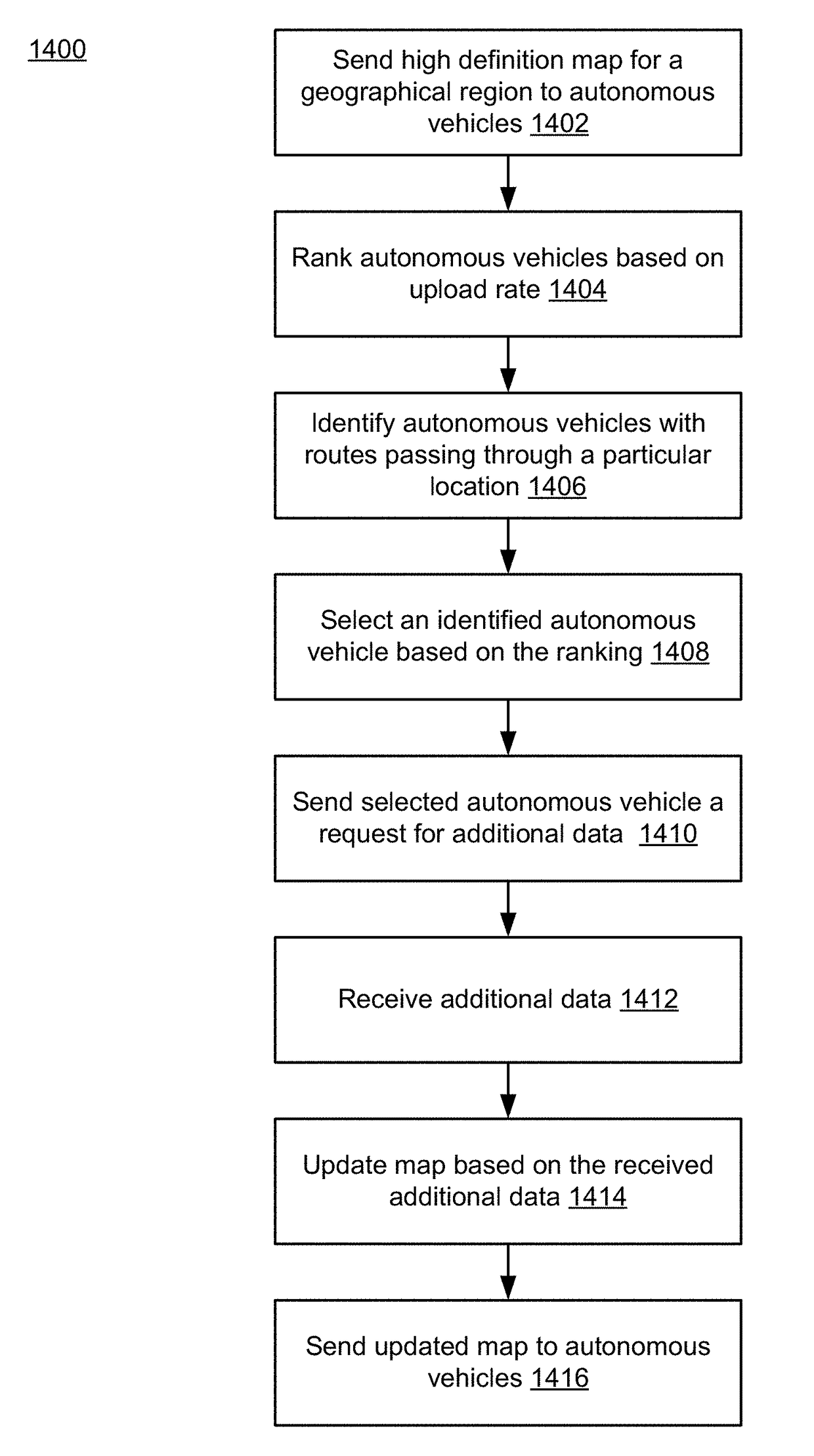
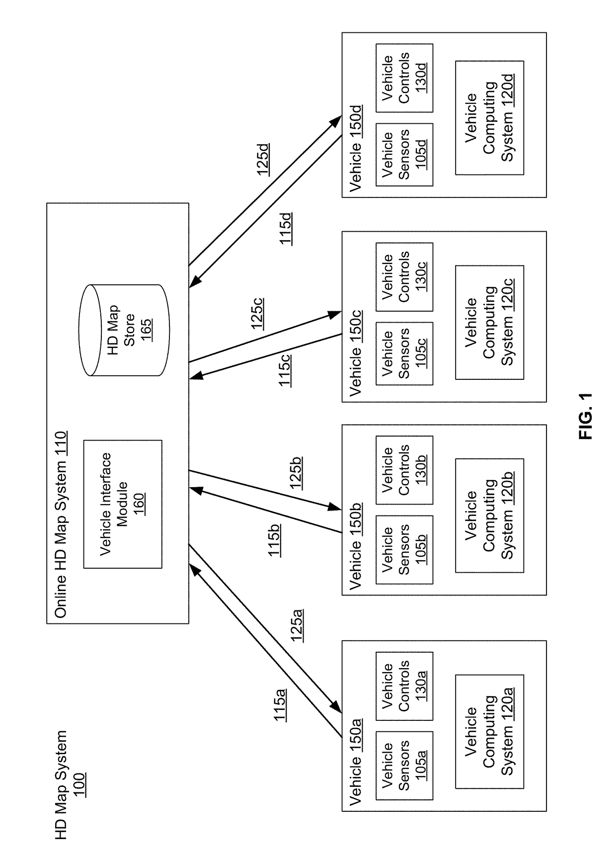
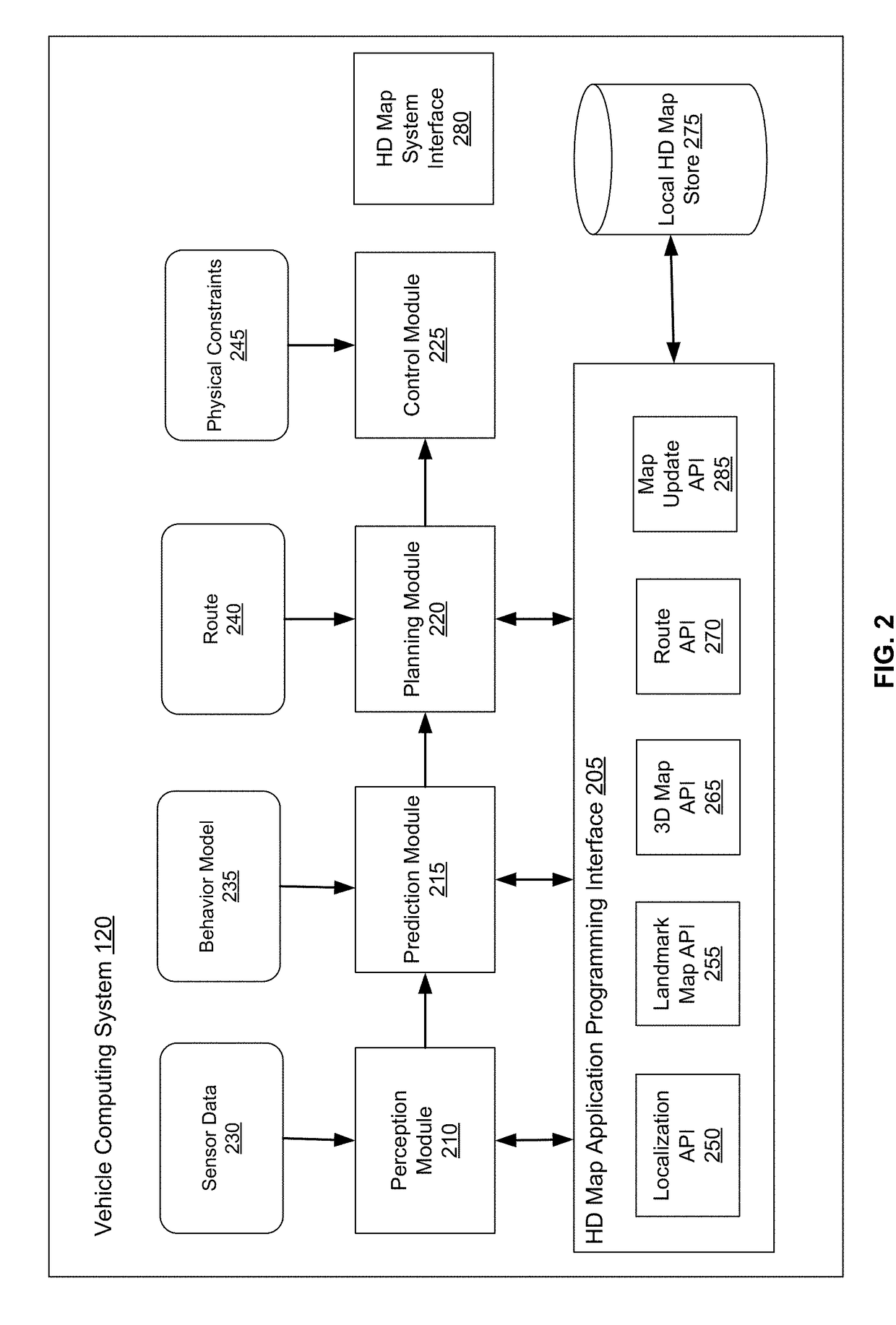
[0026]Embodiments of the invention maintain high definition (HD) maps containing up to date information using high precision. The HD maps may be used by autonomous vehicles to safely navigate to their destinations without human input or with limited human input. An autonomous vehicle is a vehicle capable of sensing its environment and navigating without human input. Autonomous vehicles may also be referred to herein as “driverless car,”“self-driving car,” or “robotic car.” An HD map refers to a map storing data with very high precision, typically 5-10 cm. Embodiments generate HD maps containing spatial geometric information about the roads on which an autonomous vehicle can travel. Accordingly, the generated HD maps include the information necessary for an autonomous vehicle navigating safely without human intervention. Instead of collecting data for the HD maps using an expensive and time consuming mapping fleet process including vehicles outfitted with high resolution sens...


PUM


Abstract

An online system build a high definition map for geographical regions based on sensor data captured by a plurality of vehicles driving through the geographical regions. The high definition map comprises landmark map including representations of driving paths and landmarks and occupancy map comprising spatial 3D representation of the road and all physical objects around the road. The vehicles provide information to update the landmark map and the occupancy map to the online system. The vehicles detect map discrepancies based on differences in the surroundings observed using sensor data compared to the high definition map and send messages describing these map discrepancies to the online system. The online system ranks the vehicles based on factors including an upload rate of the vehicle and requests data describing high definition map from vehicles selected based on the ranking.

Description

CROSS-REFERENCE TO RELATED APPLICATION[0001]This application claims the benefit of U.S. Provisional Application No. 62 / 441,069, filed Dec. 30, 2016, which is hereby incorporated by reference in its entirety.BACKGROUND[0002]This disclosure relates generally to maps for autonomous vehicles, and more particularly to updating high definition maps based on sensor data collected by to autonomous vehicles.[0003]Autonomous vehicles, also known as self-driving cars, driverless cars, auto, or robotic cars, drive from a source location to a destination location without requiring a human driver to control and navigate the vehicle. Automation of driving is difficult due to several reasons. For example, autonomous vehicles use sensors to make driving decisions on the fly, but vehicle sensors cannot observe everything all the time. Vehicle sensors can be obscured by corners, rolling hills, and other vehicles. Vehicles sensors may not observe certain things early enough to make decisions. In additi...

Claims


Application Information

Patent Timeline
Patent Type & Authority Applications(United States)
IPC IPC(8): G01C21/32G01C21/36G06T17/05G06K9/00G05D1/00G06V10/75G06V10/764G06V10/98H04L69/40
CPCG01C21/32G01C21/3635G06T17/05G06K9/00791G05D1/0088H04L67/10H04L69/40G06F16/29G05D1/0274G05D2201/0213H04L67/12G08G1/096827G01C21/3822Y04S40/18G01C21/3811G06V20/64G06V20/58G06V20/56G06V10/98H04L67/53H04L67/52G06V10/75G06V10/764G06F18/22G01C21/3848G01C21/3841G01C21/3867B60W2554/00B60W2556/50G06F18/24B60W30/0956B60W40/02G01C21/30
Inventor WHEELER, MARK DAMONWU, XIAQING JAMESLUO, WEI
Owner NVIDIA CORP
Why Eureka
Try Eureka