Joint search method for UAV multiobjective path planning in urban low altitude environment

a multi-objective, path planning technology, applied in vehicle position/course/altitude control, process and machine control, instruments, etc., can solve the problems of limited communication bandwidth, inability to directly exploit the path planning approach to perform the uav path planning, and inability to timely update the global map information for the uav, etc., to achieve the effect of small search space, low computational complexity and reduced computing power of the uav

Active Publication Date: 2018-10-25
BEIHANG UNIV
View PDF0 Cites 99 Cited by
  • Summary
  • Abstract
  • Description
  • Claims
  • Application Information

AI Technical Summary

Benefits of technology

[0023](2) The method of the invention first uses the offline search scheme to obtain the path between the starting point and the end point of the UAV. Therefore, the UAV needs not to collect the mass geographic map data online. Furthermore, it needs not to calculate a static safety index map that describes the safety of each point in the geographic map. In this way, the requirement of computing power on the UAV for solving the path planning problem is significantly reduced.
[0024](3) The method of constructing a dynamic safety index map designed by the invention has low computational complexity, and the online search method of the invention has a small search space. Therefore, the invention can quickly return a replanned safe path for the UAV and can meet the real-time requirement of the path planning.

Problems solved by technology

However, these path planning approaches cannot be directly exploited to perform the UAV path planning in the low altitude dynamic urban environment, because they rely on timely updated global and deterministic map information.
In a low altitude dynamic urban environment, the timely update of the global map information is almost unavailable to a UAV, which usually has a limited communication bandwidth.
Moreover, there are always unexpected obstacles that may not be indicated on a geography map.
In such a case, a UAV would possibly crash against the unexpected obstacles.
Although path replanning can be leveraged to mitigate the uncertainty during flying, there are at least two significant problems:
2) Dealing with the unpredictable changing surrounding environments within limited sensing range as well as limited GPS position precision.
Although these MOPP algorithms have been developed to find an achievable path for a UAV flying in a complex environment, none of them has addressed the problem of dynamic obstacle avoidance.
Although the proposed framework is certified to perform well in finding collision-free paths for a UAV, it only focused on solving a single objective (i.e., safety) path planning problem.
However, these methods only concentrate on online path planning.
They cannot make use of offline information, i.e., the geography map, to reduce the travel time.

Method used


Image

  • Joint search method for UAV multiobjective path planning in urban low altitude environment
  • Joint search method for UAV multiobjective path planning in urban low altitude environment
  • Joint search method for UAV multiobjective path planning in urban low altitude environment

Examples


Embodiment Construction

[0040]The invention will now be further described referring to the attached drawings and examples.

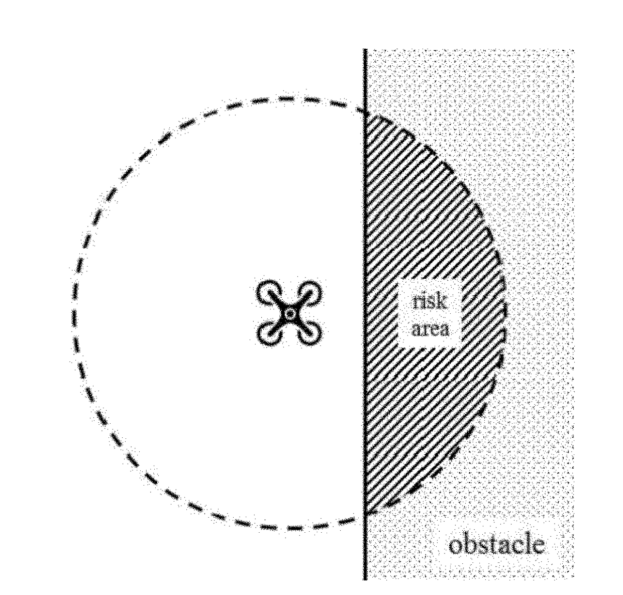
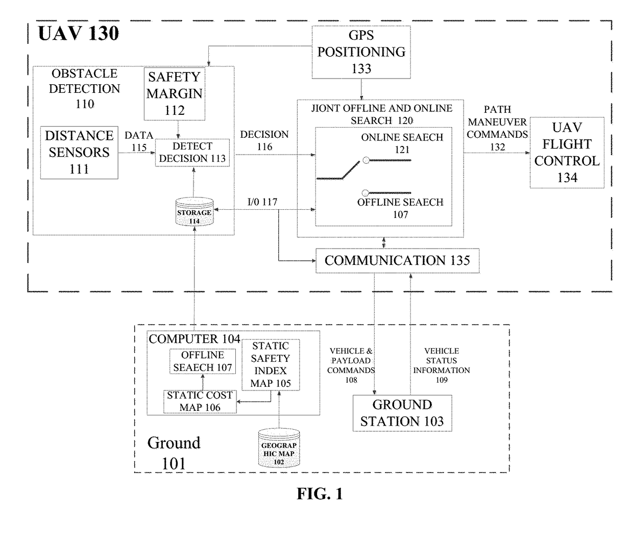
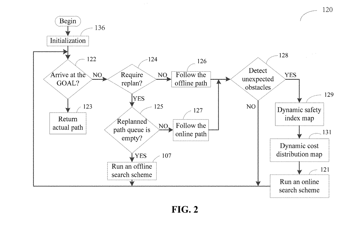
[0041]The multiobjective path planning problem to be solved by the invention is to find the Pareto optimal path for the UAV 130 in a low altitude urban dynamic environment. The Pareto path can ensure the UAV 130 flight safety as well as the shortest possible flight time of arriving at the destination. For this purpose, the invention proposes two types of safety index maps, that is, static safety index map 105 and dynamic safety index map 129. The static safety index map 105 is constructed based on the known obstacles marked on the geographic map 102 (e.g., Baidu map). The dynamic safety index map 129 is constructed based on the dynamic obstacles that are not marked on the geographic map 102 but are proactively detected by the UAV 130. With these two maps, the invention generates the static cost distribution map 106 and the dynamic cost distribution map 131 respectively. Meanwhile, the i...


PUM


Abstract

A joint search method for UAV multiobjective path planning in an urban low altitude environment first constructs a static safety index map based on static known obstacles. Meanwhile, based on proactively detected obstacles that are not marked on a geographic map by a UAV, the method constructs online a dynamic safety index map. Second, a multiobjective path planning problem is solved using a joint offline and online search method. Moreover, this method first plans offline the least cost path from a starting point to an end point and then invokes the online search scheme to replan online a changed path when the UAV detects unknown obstacles. Thus, the UAV can avoid dynamic obstacles effectively. The online search scheme has a small search space and can quickly replan a safe path for the UAV, thus satisfying the requirement of UAV on the real-time path planning.

Description

CROSS REFERENCE TO RELATED APPLICATIONS[0001]This Application claims priority of China Patent Application No. 201710255262.6, filed on Apr. 19, 2017, the entirety of which is incorporated by reference herein.BACKGROUND OF THE INVENTION1. Technical Field[0002]The invention belongs to the technical field of unmanned aerial vehicle path planning. Specifically, the invention refers to a joint-offline-and-online-based search method of multiobjective path planning for a UAV in urban low altitude environment.2. Description of the Prior Art[0003]Since the federal aviation administration (FAA) unveiled plans for domestic unmanned aerial vehicles (UAVs) to take off by 2015, the usage of UAVs has received significant attention. In future smart cities, UAV itself would play an important role in, but not limited to, cargo delivery, emergency communications, reconnaissance, fire-fighting, aerial photo, remote sensing, disaster rescue, etc. Moreover, when using internet of things (IoT) to improve ...

Claims


Application Information

Patent Timeline
Patent Type & Authority Applications(United States)
IPC IPC(8): G08G5/00B64C39/02G08G5/04
CPCG08G5/0069B64C39/024G08G5/0034G08G5/0039G08G5/045G05D1/12G05D1/102B64U2201/00
Inventor CAO, XIANBINXIAO, ZHENYUYANG, PENGYIN, CHAOXI, XINGWU, DAPENG
Owner BEIHANG UNIV
Why Eureka
Try Eureka