Overhead structure determination device and driving assistance system

Inactive Publication Date: 2018-11-29
TOYOTA JIDOSHA KK
View PDF0 Cites 8 Cited by
  • Summary
  • Abstract
  • Description
  • Claims
  • Application Information

AI Technical Summary

Benefits of technology

[0029]The driving assistance system according to the second aspect of the present disclosure uses the high-accuracy determination result of the overhead structure determination device according to the first aspect of the present disclosure. More specifically, when the overhead structure determination device determines that the target ahead is the overhead structure, the driving assistance control device excludes the target ahead (overhead structure) from the target object in the driving as

Problems solved by technology

When an erroneous determination is made that such an overhead structure is an obstacle or a preceding vehicle, there is a possibility of unneeded deceleration of the vehicle.
Unneeded deceleration (erroneous deceleration) of the vehicle makes a driver feel uncomfortable or anxious and

Method used


Image

  • Overhead structure determination device and driving assistance system
  • Overhead structure determination device and driving assistance system
  • Overhead structure determination device and driving assistance system

Examples


first example

3-1. First Example

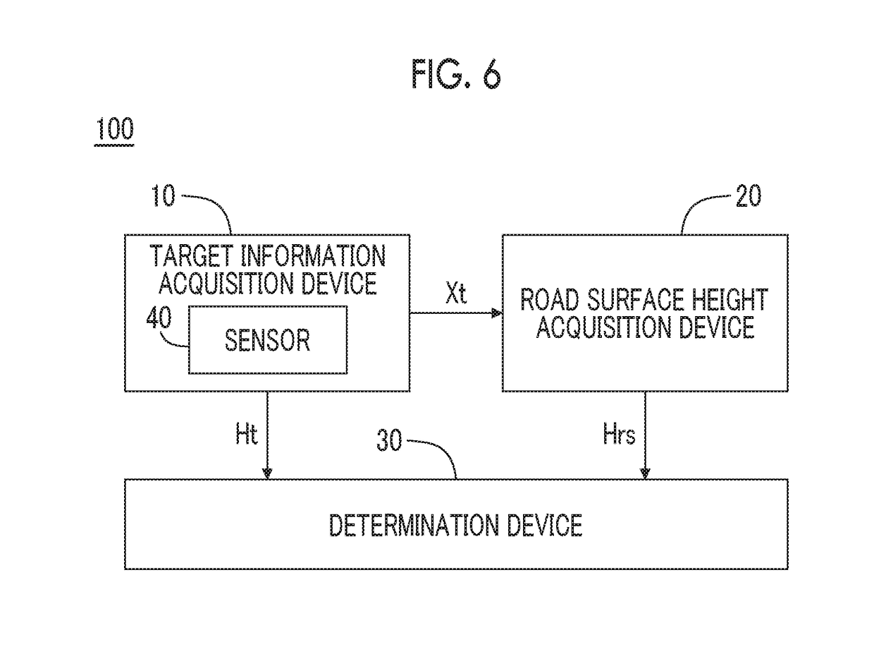
[0082]FIG. 8 is a block diagram illustrating a first example of the road surface height acquisition device 20 according to the present embodiment. In the first example, the road surface height acquisition device 20 includes a GPS receiver 50, a three-dimensional map database 60, and a road surface height acquisition unit 21.

[0083]The GPS receiver 50 receives signals transmitted from a plurality of GPS satellites and calculates the position and the azimuth of the vehicle 1 based on the received signals. The GPS receiver 50 transfers position and azimuth information indicating the calculated position and the azimuth to the road surface height acquisition unit 21.

[0084]The three-dimensional map database 60 is a database of three-dimensional map information that indicates the three-dimensional position of roads. For example, the three-dimensional position is configured with the latitude, the longitude, and the relative height with respect to a reference point. The thre...

second example

3-2. Second Example

[0087]FIG. 9 is a block diagram illustrating a second example of the road surface height acquisition device 20 according to the present embodiment. In the second example, the road surface height acquisition device 20 includes the sensor 40, a road surface estimation unit 22, and a road surface height calculation unit 23.

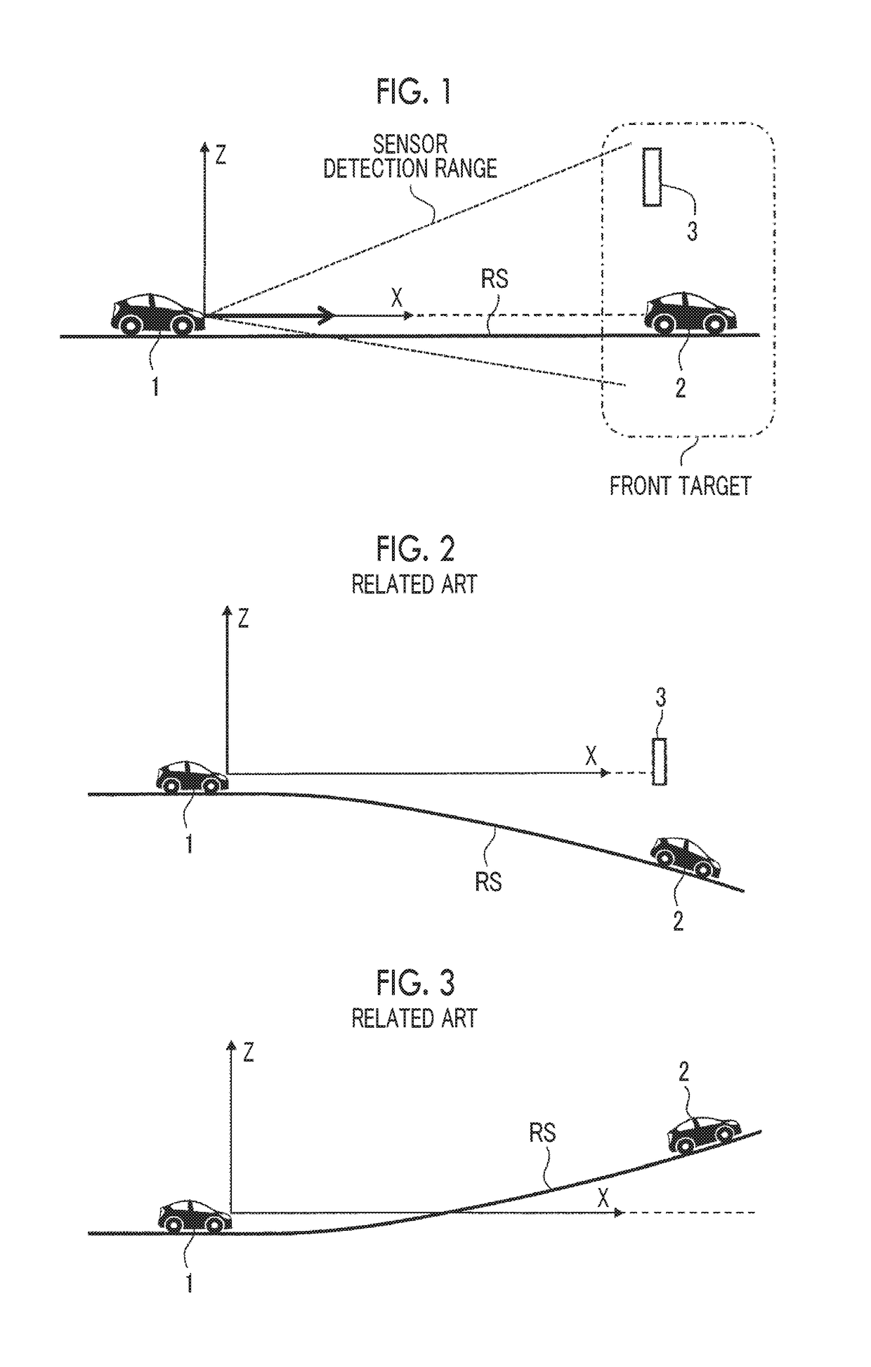
[0088]As described above, the sensor 40 detects the environment around the vehicle 1. The sensor 40 is exemplified by LIDAR, a radar, a camera, a sonar, an infrared sensor, and the like. The road surface estimation unit 22 estimates the road surface RS in front of the vehicle 1 based on the detection result of the sensor 40.

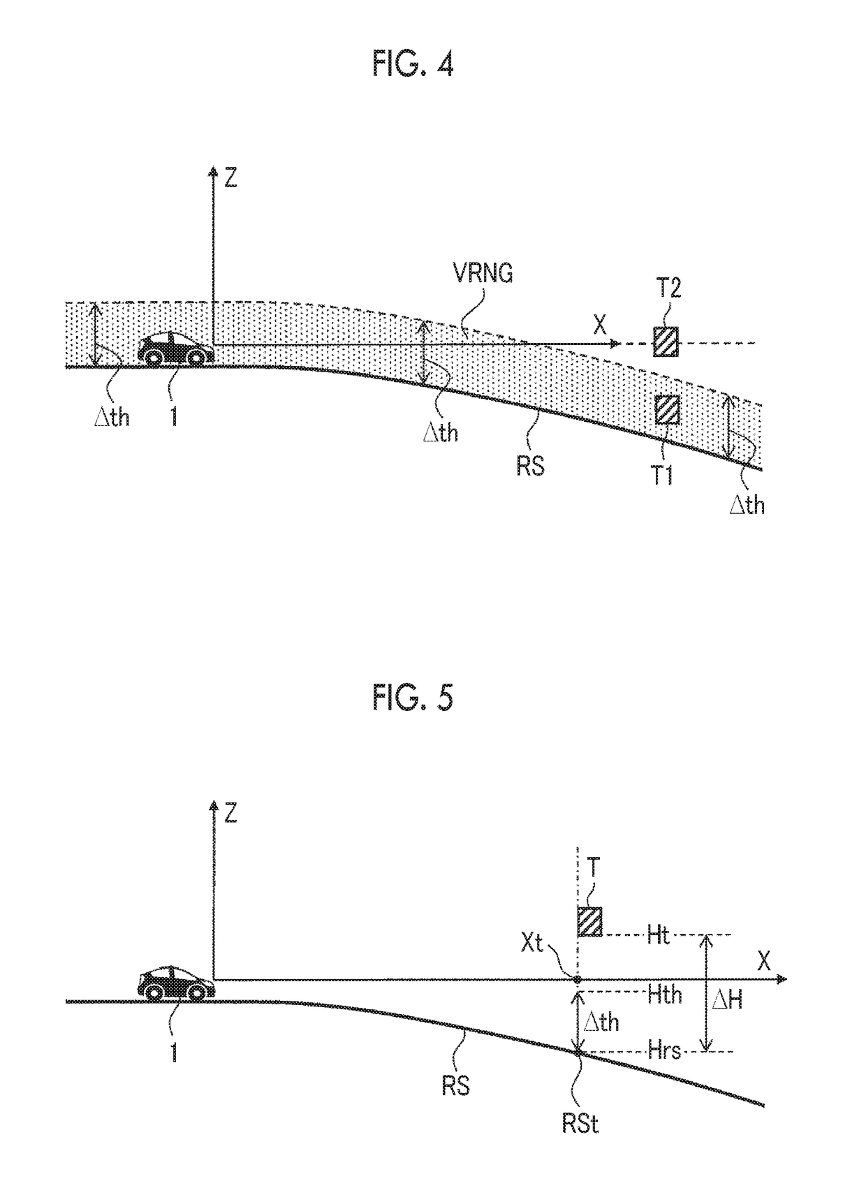
[0089]FIG. 10 is a conceptual diagram for describing a road surface estimation method in the second example. The road surface estimation unit 22 detects a plurality of road surface points Prs present in front of the vehicle 1 based on the detection result of the sensor 40. Each road surface point Prs is a point that represents t...

third example

3-3. Third Example

[0096]A configuration of the road surface height acquisition device 20 in a third example is the same as that illustrated in FIG. 9. The difference between the third example and the second example is the method of determining the estimated road surface RSe in the road surface estimation unit 22.

[0097]FIG. 11 is a conceptual diagram for describing a road surface estimation method in the third example. In the example illustrated in FIG. 11, a plurality of specific structures 4 having a known height from the road surface RS is disposed on the road surface RS. The specific structures 4 are exemplified by delineators, guardrails, and the like.

[0098]The road surface estimation unit 22 detects and identifies the specific structures 4 based on the detection result of the sensor 40. The process of detecting the specific structures 4 is the same as the target detection process of the target information acquisition device 10. Accordingly, the target information acquisition de...


PUM


Abstract

An overhead structure determination device mounted in a vehicle includes a sensor, a target information acquisition device, a road surface height acquisition device, and a determination device. The target information acquisition device detects a target in front of the vehicle using the sensor and acquires a relative position and a relative height of the target with respect to the vehicle. The road surface height acquisition device acquires a relative height of a below-target road surface with respect to the vehicle as a road surface height. The below-target road surface is a road surface at the relative position of the target. When a difference between the relative height of the target and the road surface height exceeds a threshold, the determination device determines that the target is an overhead structure present above a height of the vehicle.

Description

INCORPORATION BY REFERENCE[0001]The disclosure of Japanese Patent Application No. 2017-105750 filed on May 29, 2017 including the specification, drawings and abstract is incorporated herein by reference in its entirety.BACKGROUND1. Technical Field[0002]The present disclosure relates to an overhead structure determination device and a driving assistance system mounted in a vehicle.2. Description of Related Art[0003]A driving assistance system mounted in a vehicle performs a driving assistance control for assisting in vehicle driving. A following traveling control or a collision avoidance control is known as the driving assistance control assisting in vehicle driving.[0004]The following traveling control is a control for following a preceding vehicle while maintaining a set inter-vehicle distance. When the inter-vehicle distance to the preceding vehicle is less than the set value, the driving assistance system automatically operates a braking device to decelerate the vehicle.[0005]The...

Claims


Application Information

Patent Timeline
IPC IPC(8): G08G1/16G06K9/00G06K9/62G05D1/02B60T7/22B60T8/171B60T8/172
CPCG08G1/166G06K9/00825G06K9/00798G06K9/6288G05D1/024G05D1/0246G05D1/0257B60T7/22B60T8/171B60T8/172G05D1/027G05D1/0274G08G1/165H04L67/12G06K2209/21G05D2201/0213B60T2201/022B60T2210/32G01S17/931G05D1/0248H04W4/021H04W4/46G06V20/56G06V20/584G06V20/588G06V2201/07G06F18/25
Inventor KOMORI, TERUMOTOKOYAMA, NAGISA
Owner TOYOTA JIDOSHA KK
Why Eureka
Try Eureka