Novel nonlinear method for area-wide near surface air temperature precision retrieval

a precision retrieval and nonlinear technology, applied in the field of meteorological data processing, can solve the problems of limiting the research and application of ta, the complexity of land surface characteristics and atmosphere variability in temperature retrieval over a large area remains a difficult task, and the temperature retrieved from satellite data can deviate from reality, so as to improve the accuracy of integrated learning, improve the accuracy of retrieval, and improve the robustness of area-wide application.

Active Publication Date: 2019-02-21
GUANGXI INST OF METEOROLOGICAL DISASTER REDUCING RES +1
View PDF2 Cites 51 Cited by
  • Summary
  • Abstract
  • Description
  • Claims
  • Application Information

AI Technical Summary

Benefits of technology

[0106]This invention employs super non-linear algorithms to resolve issues of current technology in information fusion for near surface air temperature retrieval. The outcome errors are independent of cloud and topographical characteristics. Specifically, the retrieval model combines ground and space information to obtain an accurate near surface air temperature image that overcomes the interference of cloud. The retrieving technology docked with GIS realizes combined application of multi-types of information to improve retrieving accuracy and robustness of area-wide application. Compared to our previous patent of the same technology, the current patent represents a great improvement.
[0121](4) The installment of multiple δ as 0<δ0<δ1<δ2< . . . δi . . . <δs can rapidly reduce MAE where pixels with AE≥δ0 of the different sub-models concentrate. A deep gap of AE appears near δi. However, the required RAM space for computation will multiply.

Problems solved by technology

However, accurate measure of area-wide Ta remains difficult, thus limits the research and application of Ta.
The main challenge is that temperatures retrieved from satellite data can deviate from reality due to various inevitable influential factors of surface radiation and atmosphere.
Brightness temperature represented by satellite IR bands may not be a true representation of temperatures, and such discrepancies cause uncertainty.
How to overcome the complexity of land surface characteristics and atmosphere variability in temperature retrieving over a large area remains a difficult task.
However, all those algorithms basically are linear models with limited number of variables without considering ground vegetation and topographical characters.
In addition, errors of these models are accumulative and unpredictable.
[10] developed a fusion algorithm for temperature imagery of different spatial resolutions, but had no solution for imagery fusion of different temporal resolutions.
Many developed models [8, 10-17] are not robust enough and only deliver acceptable temperature estimations under specific conditions.
These limitations impose a great difficulty in developing temperature remote sensing products.
Specifically, in Southern China, cloudy days are regular occurrence, and the area has complex topography and underlying surface characteristics.
It is extremely difficult to retrieve Ta with acceptable errors and develop products for large areas because all currently available methods produce expected results only under specific conditions, and require corrections of certain variables, e.g. atmospheric water vapor profile, to avoid large errors.
Furthermore, errors of these models are intrinsically accumulative and unpredictable.
These algorithms include very limited number of variables and unable to consider the effect of important temperature influential variables such as ground vegetation and topographical characters, etc.
However, the patented modeling technology[20] (Patent#ZL201510103565.7) still has shortcomings of uneven error distribution among sub-models, and unexplainable and irregular errors for certain pixels.
However, unmanned weather stations are mainly distributed in plat areas and cannot represent differences resulted from complex topographical characteristics.
A digital elevation model (DEM) provides 3D representation of the terrain's surface of Earth with a spatial resolution as high as 100×100 m. Although the IR data collected by MODIS and FY2 / FY3 satellites can be used for Ta retrieving, overcoming the interference of cloud still is an issue, making all-time monitoring not feasible.
Compared to the data collection capability, a lack of data application and analysis software technology is apparent.
A key urgent challenge is how to utilize the massive data collected by the unmanned weather stations and satellites in which huge resources have already invested to provide high quality (high accuracy, resolution and reliability) real-time weather data services.

Method used


Image

  • Novel nonlinear method for area-wide near surface air temperature precision retrieval
  • Novel nonlinear method for area-wide near surface air temperature precision retrieval
  • Novel nonlinear method for area-wide near surface air temperature precision retrieval

Examples


case study # 1

Case Study #1

[0131]A method for area-wide near surface air temperature precision retrieval includes the following steps:

[0132]Step I. constructing raw data records and normalization, include:

[0133](1) set the target area and time. Locate the unmanned weather station locations. Set the temporal data collection window of 2-72 hours around the set time. Record temporal data according to the unmanned weather station recording time within the collection window.

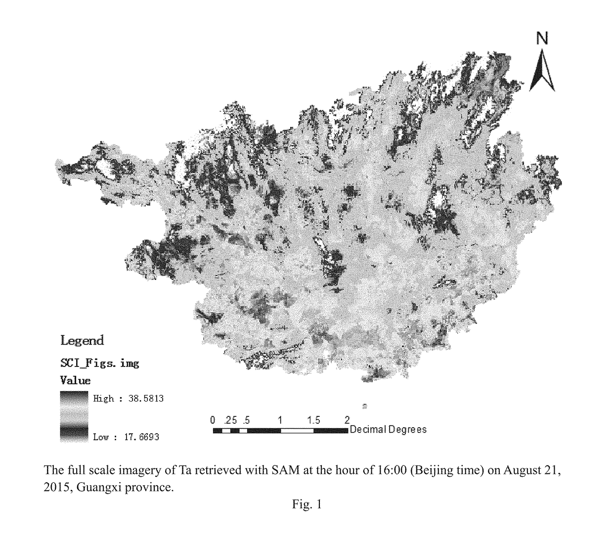
[0134]In this case study, the entire Guangxi province of China (between latitude 20°54′-26°24′ N and longitude 104° 26-112° 04′ E with an area of 236,670 km2) was the targeted study area with 1359 unmanned weather stations. The uploaded temperature readings of these weather stations were collected and carefully examined and verified by the basic weather stations. The targeted single temporal point was Aug. 21, 2015 at 16:00 hour (Beijing time). MODIS and FY2C / D hourly data between 00 hour of Aug. 21 and 23 hour of Aug. 31 2015 were...

case study 2

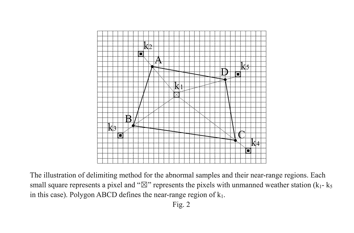
[0205]Step VIII. identifying abnormal samples in surfTf and define their near-range regions.

[0206]FIG. 2 illustrates Step VIII—abnormal samples and their near-range regions. Each small square represents a pixel and “” represents the pixels with unmanned weather station (k1-k5 in this case). Polygon ABCD defines the near-range region of k1.

σ=dk1Adk1k2

[0207]FIG. 9 illustrates Step VIII and IX.

[0208]The black dot represents unmanned weather station locations; the square represents near-range regions while the light square represents unmanned weather station with normal error and its near-range region; the dark square represents unmanned weather station with abnormal error and its near-range region.

[0209]FIG. 9(a) shows abnormal error pixels (δ=δ0=2.0° C.) (E3 and A6) and their near-range regions in the full imagery of retrieved near surface air temperature created with the 1st sub-model (Full surfT1). FIG. 9(b) shows abnormal error pixels when δ=δ0=2.0° C. (E3 and C4) and near-range re...

case 1

Comparative Analysis Case 1

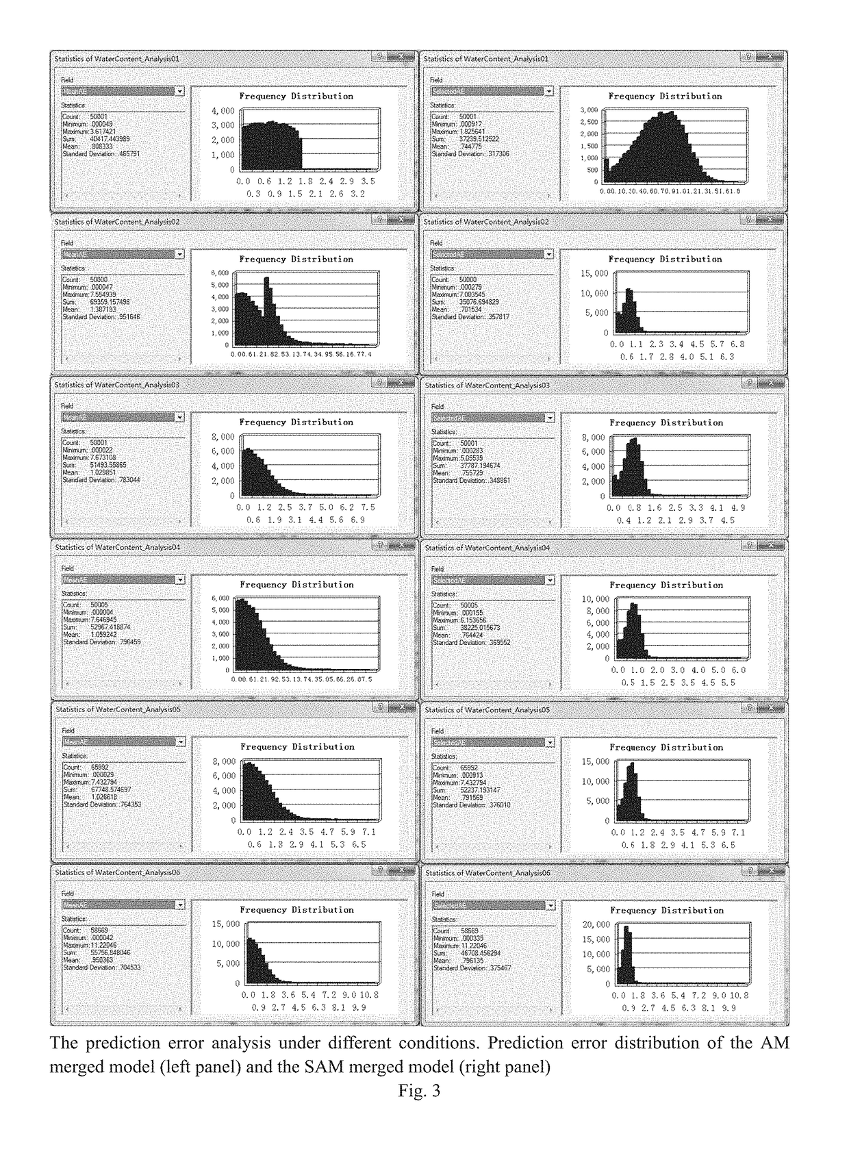
[0233]With the same dataset (16 hour, Aug. 21, 2015), Tables 2-4 illustrate the comparisons between the selective arithmetic mean method (SAM) of the current patent and the arithmetic mean method (AM) of Patent #201510103565. Table 2 shows the results of AM to compare to Tables 3 and 4.

[0234]In Table 2, column 2 is the error evaluation of the 1st sub-model for 16 hour Aug. 21, 2015 surfT1. Column 3 is the error evaluation of the 2nd sub-model for 16 hour Aug. 21, 2015 surfT2. Column 4 is the error evaluation of the 3rd sub-model for 16 hour Aug. 21, 2015 surfT3. Column 5 is the error evaluation of the 3rd sub-model for 16 hour Aug. 21, 2015 surfT3 using SAM.

[0235]Table 3 and 4 show the error analysis of δ0=2.0 / δ1=3.0 and δ0=2.5 / δ1=3.0

TABLE 2Prediction errors of sub-models of the arithmetic mean method*AMSAMModelVEC1ModelVEC2ModelVEC3ModelVEC3AM MergedParametersγ = 3.0γ = 5.0γ = 2.0γ = 5.0ModelMAE (° C.)1.362 1.694 1.5831.4431.137RMSEs (° C.)1.779 2.066 1.9...


PUM

PropertyMeasurementUnit
time pointaaaaaaaaaa
digital elevation modelaaaaaaaaaa
temperaturesaaaaaaaaaa

Abstract

A novel nonlinear method for area-wide near surface air temperature precision retrieval is described. The steps include: First, construct the 1st sub-model modelVEC1 to the f-th sub-model modelVECf. Establish and normalize raw data vectors of each gridded pixel sBlkVEC in the targeted area. Calculate the retrieved full maps (surfTf) of near surface air temperatures using each sub-model. Then, identify abnormal samples and define their near-range regions in surfTf Apply a selective arithmetic mean (SAM) approach to achieve precision temperature map surfT. And finally apply further modification to the pixels of surfT where pixlf∈badsurfTδf is true to all f=1, 2, 3, . . . .Using the super nonlinear algorithm, this invention provides a solution of retrieving near surface air temperature based on combinations of various factors (information fusion) to achieve satisfied prediction errors, which are independent of cloud levels and topographic characteristics. Specifically, the information fusion between space and ground surface enables reliable prediction of near surface air temperature maps overcoming the inference of cloud.

Description

TECHNICAL FIELD[0001]This invention relates to the technical field of meteorological data processing, in particular, it is a method for area-wide near surface air temperature precision retrieval.BACKGROUND[0002]Near surface air temperature (Ta) is commonly measured at 1.5-2.0 m above the ground in a thermometer shelter of weather stations [1-2]. It is an important parameter of energy balance on the earth's surface [3], quantitatively representing the interaction between the earth's surface and the atmospheric layer, and between soil surface and under-layers [2-3]. Moreover, Ta is closely associated with human activity [4], crop and forest growth, plant disease and insect pest outbreaks, and cold or heat stresses on crops, etc. [1-2]. Ta measurement is also critical for meteorological forecast [5] for every kinds of elements. Other weather related factors such as humidity, evaporation / transpiration amounts, drought, ground surface temperature and humidity, etc., are closely related t...

Claims


Application Information

Patent Timeline
Patent Type & Authority Applications(United States)
IPC IPC(8): G06F17/50G01K1/02G06N99/00
CPCG06F17/5009G01K1/026G06N20/00G01K1/024G06F2217/16G06F30/20G01W1/00G06N20/10G06F2111/10
Inventor QIN, JIANGLINYANG, XIUHAOLUO, JITONGFU, HELEI, XIUFENGWEI, JUNQIN, YUANRUIYANG, ZIXIN
Owner GUANGXI INST OF METEOROLOGICAL DISASTER REDUCING RES
Why Eureka
Try Eureka