Supercharge Your Innovation With Domain-Expert AI Agents!

Method for flight path planning of unmanned aerial vehicles using flying routes of birds

Active Publication Date: 2020-01-09
KAO SHU HUI
View PDF0 Cites 2 Cited by
  • Summary
  • Abstract
  • Description
  • Claims
  • Application Information

AI Technical Summary

Benefits of technology

The present invention provides a method for planning the flight path of unmanned aerial vehicles (UAVs) using flying routes of birds. This is achieved by installing multiple recording devices on racing pigeons to record their flying tracks between two places, and using an analyzing device to identify the most effective and obstruction-free flight path. The flight path is then inputted into the UAV for safe and effective flight between the two places. The method utilizes the animal instinct of racing pigeons to automatically avoid obstruction during flight to create multiple flying tracks, and selects one most appropriate flying track as the flight path of the UAV based on the minimum flying distance or time. This results in the UAV flying without concern of colliding with obstruction and rapidly reaching the destination to save time and energy.

Problems solved by technology

However, when UAVs are used in metropolitan areas full of high-rise buildings, obstruction avoidance and wind effect on high-rise buildings become issues thereto.
Despite no stoppage caused by traffic jam and traffic lights in an open airspace, UAVs may still encounter other obstructions, such as high-voltage towers, electric wires and cables, electric posts, signs and the like.
If colliding with any of the obstructions, UAVs may be out of order and crash and the falling parts or pieces may hit passersby or other objects on the ground to result in hazard to human life or property damage.
When located beyond the limited distance, the UAVs either fail to continuously fly any more or collide with obstructions due to failure of obstruction identification.
Supposing that light of sight between UAVs and users fails to be maintained, even if the UAVs are located within a controllable range, users are still unable to determine the flying direction of the UAVs.
However, if the average height of the buildings is high, the vertical ascending height of the UAVs should increase as well, not only costing more energy but taking more time to fly to the destination.
Meanwhile, UAVs encountering unstable air flow in a high-altitude environment are crash-prone.
However, such method has a low efficiency as far as cruising radius and flight path planning are concerned.

Method used


Image

  • Method for flight path planning of unmanned aerial vehicles using flying routes of birds
  • Method for flight path planning of unmanned aerial vehicles using flying routes of birds
  • Method for flight path planning of unmanned aerial vehicles using flying routes of birds

Examples


Embodiment Construction

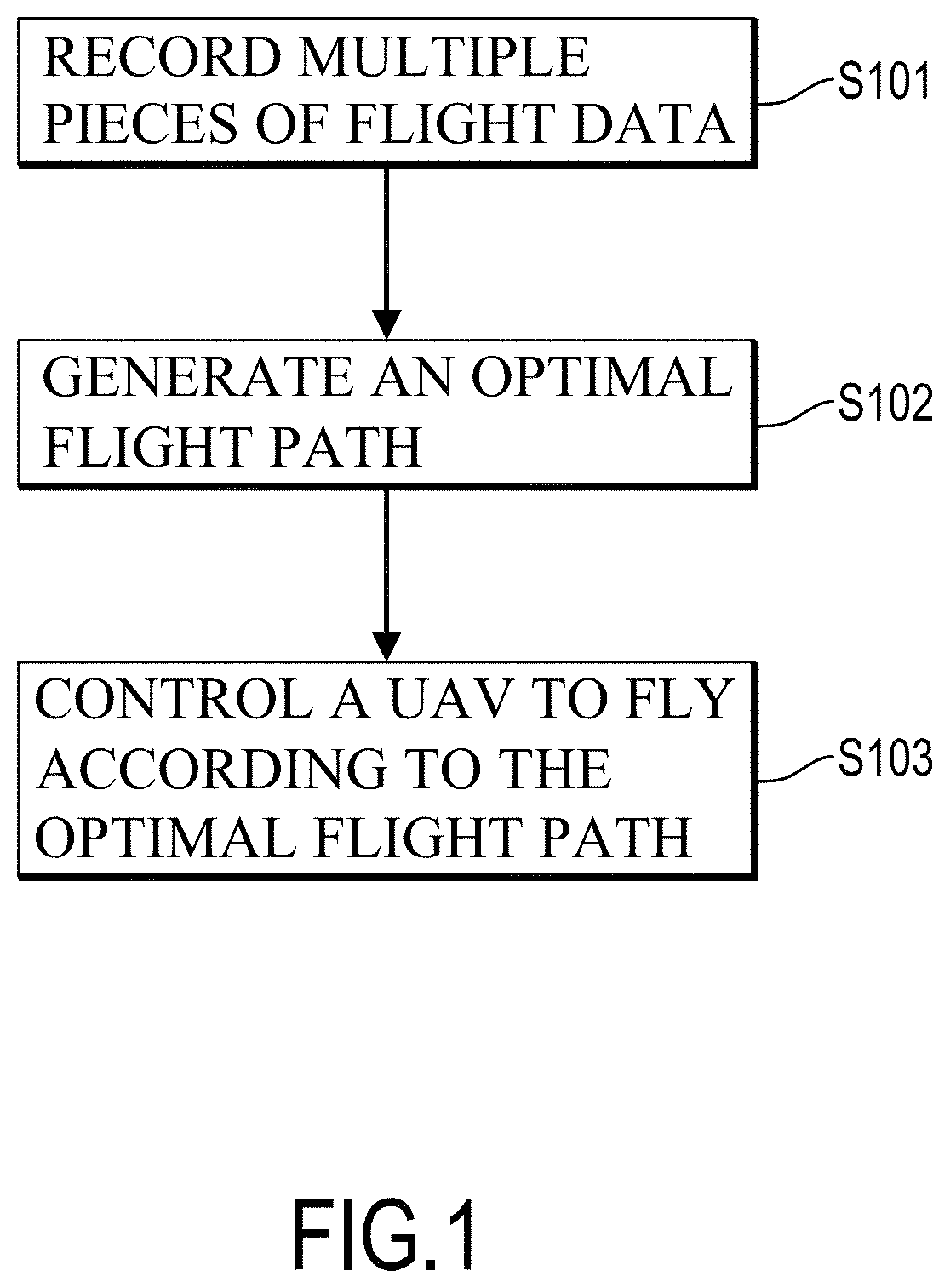
[0028]With reference to FIG. 1, a method of flight path planning of unmanned aerial vehicles using flying routes of birds in accordance with the present invention includes the following steps.

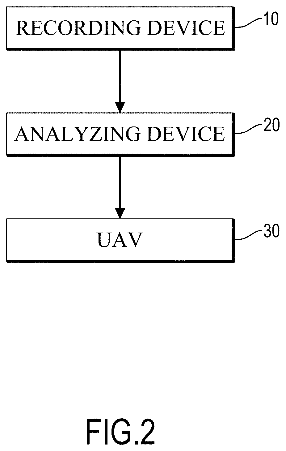
[0029]Step S101: Record multiple pieces of flight data. With simultaneous reference to FIG. 2, firstly multiple recording devices 10 are respectively installed on multiple birds, which may be racing pigeons. Given racing pigeons as an example, the multiple racing pigeons are released from a first designated point and predefine a second designated point as a destination. In an embodiment, each recording device 10 is an electronic foot ring and may configure a fixed time period therein beforehand, which may be 2 seconds or 5 seconds or is adjustable based on users' demands. During the flight of the racing pigeons, the recording devices record one piece of flight data once every the fixed time period in generation of the multiple pieces of flight data, which record latitude, longitude, height, UTC...


PUM


Abstract

A method for flight path planning of unmanned aerial vehicles using flying routes of birds includes: recording multiple pieces of flight data, wherein multiple recording devices are used to record the multiple pieces of flight data when the birds fly from a first designated point to a second designated point and are respectively installed on the birds; generating an optimal flight path, wherein an analyzing device collects the multiple pieces of flight data and calculates the optimal flight path; and controlling a UAV to fly according to the optimal flight path, wherein the optimal flight path is inputted to the UAV. By virtue of bird's nature automatically avoiding obstruction and adapting to wind direction and air flow, multiple obstruction-free recording points between two places can be acquired to form an optimal flight path with the shortest flying time or distance.

Description

BACKGROUND OF THE INVENTION1. Field of the Invention[0001]The present invention relates to a method for flight path planning and, more particularly, to a method using racing pigeons that carry recording devices to fly, planning optimal flight paths through calculation using data associated with acquired flight paths, and inputting the optimal flight paths to unmanned aerial vehicles (UAVs) for the UAVs to fly according to the optimal flight paths.2. Description of the Related Art[0002]Recently, UAVs have become more and more widespread. The high mobility of UAVs is the key point to make them widely acceptable. Given the aerial photogrammetry as an example, an UAV equipped with a camera or video recorder can fly to places that are inaccessible to monitor natural disasters, such as earthquake, volcano eruption, flood or land slide, or to urban areas to keep track of traffic flow, road structure inspection and construction overview of public facilities, so as to acquire sufficient accu...

Claims


Application Information

Patent Timeline
IPC IPC(8): G08G5/00G05D1/00G05D1/02B64C39/02
CPCB64C2201/128B64C2201/141G08G5/0034G08G5/0069G05D1/0088B64C2201/127G05D1/0202B64C39/024G05D1/101G08G5/0086G01C21/20B64U2201/10B64U2101/30B64U2101/60
Inventor KAO, SHU-HUI
Owner KAO SHU HUI
Features
  • R&D
  • Intellectual Property
  • Life Sciences
  • Materials
  • Tech Scout
  • Unparalleled Data Quality
  • Higher Quality Content
  • 60% Fewer Hallucinations
Learn More