Supercharge Your Innovation With Domain-Expert AI Agents!

Mapping radio data layers of radio map to floor identifiers

a radio map and radio data technology, applied in the field of positioning, can solve the problems of -3 m, difficult to achieve coverage (100%), and inability to deliver such performance indoors, and achieve the effect of more efficiently and/or accurately

Pending Publication Date: 2020-11-19
HERE GLOBAL BV
View PDF6 Cites 0 Cited by
  • Summary
  • Abstract
  • Description
  • Claims
  • Application Information

AI Technical Summary

Benefits of technology

The patent text describes a solution for improving the accuracy and efficiency of indoor positioning using radio maps and geographic maps. The technical problem addressed is the challenge of integrating the existing infrastructure in buildings with the existing capabilities of consumer devices to achieve global scalability, low maintenance and deployment costs, and offer an acceptable end-user experience. The solution involves using radio signals from existing infrastructure like Wi-Fi and Bluetooth to capture the dynamics of the indoor radio propagation environment in a compressible and highly accurate way, and using crowdsourcing to harvest the necessary data for creating the radio maps. However, the text also highlights the challenge of connecting the abstract indexing of the radio maps with the actual floor levels identifiers that are meaningful to humans.

Problems solved by technology

The “traditional” positioning technologies, which are mainly used outdoors, i.e. satellite and cellular positioning technologies, cannot deliver such performance indoors that would enable seamless and equal navigation experience in both environments.
The required positioning accuracy (2-3 m), coverage (˜100%) and floor detection are challenging to achieve with satisfactory performance levels with the systems and signals that were not designed and specified for the indoor use cases in the first place.
Satellite-based radio navigation signals simply do not penetrate through the walls and roofs for the adequate signal reception and the cellular signals have too narrow bandwidth for accurate ranging by default.
This is rather expensive and will take a considerable amount of time to build the coverage to the commercially expected level, which can in some cases narrow the potential market segment to only a very thin customer base e.g. for health care or dedicated enterprise solutions.
Also, the diversity of these technologies makes it difficult to build a globally scalable indoor positioning solution, and the integration and testing will become complex if a large number of technologies needs to be supported in the consumer devices, such as smartphones.
However, the technical challenges related to the harvesting, processing, redundancy, ambiguity and storing the crowd-sourced data need to be understood and solved first, before the radio map creation can be based on the fully crowdsourced data.
However, the missing part is the connection between the abstract indexing of these radio data layers of radio maps with the actually used floor level identifiers that are meaningful to humans.
Because indoor maps use the human-readable floor levels identifiers, the lack of such an association can mean in the worst case that it may not be possible to present the correct floor of the indoor map to the user, when using indoor positioning.

Method used


Image

  • Mapping radio data layers of radio map to floor identifiers
  • Mapping radio data layers of radio map to floor identifiers
  • Mapping radio data layers of radio map to floor identifiers

Examples


embodiment 1

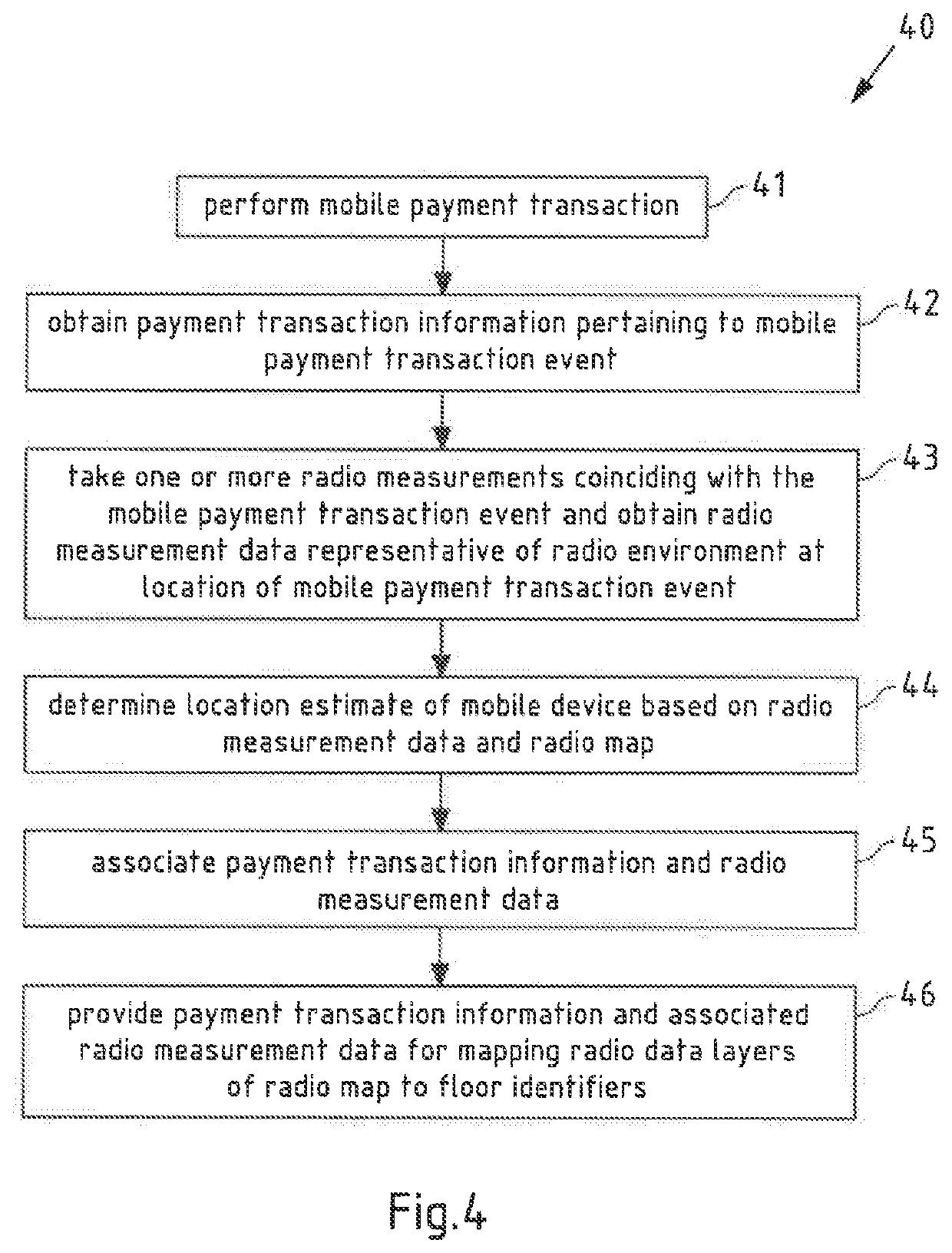
[0160]A method, performed by at least one apparatus, the method comprising:[0161]obtaining payment transaction information pertaining to a mobile payment transaction event with a mobile device;[0162]obtaining radio measurement data representative of a radio environment at a location of the mobile payment transaction event;[0163]associating the payment transaction information and the radio measurement data; and[0164]providing the payment transaction information and the associated radio measurement data for mapping radio data layers of a radio map to floor identifiers.

embodiment 2

[0165]The method of embodiment 1, the method further comprising:[0166]performing, by the mobile device, the mobile payment transaction.

embodiment 3

[0167]The method of embodiment 1 or 2, wherein the payment transaction information comprises one or more of:[0168]information representative of a name of a transaction partner involved in the mobile payment transaction event;[0169]information representative of a name of a business, at which the mobile payment transaction event took place;[0170]information representative of a location, at which the mobile payment transaction event took place;[0171]an identifier of the mobile payment transaction event; and / or[0172]a time of the mobile payment transaction event.


PUM


Abstract

A method and apparatus are provided that obtain payment transaction information pertaining to a mobile payment transaction event with a mobile device; obtain radio measurement data representative of a radio environment at a location of the mobile payment transaction event; associate the payment transaction information and the radio measurement data; and provide the payment transaction information and the associated radio measurement data for mapping radio data layers of a radio map to floor identifiers.

Description

CROSS-REFERENCE TO RELATED APPLICATION[0001]This application claims priority to European Application No. 19174910.0, filed May 16, 2019, the entire contents of which are incorporated herein by reference.FIELD OF THE INVENTION[0002]The invention relates to the field of positioning. Particularly, the invention describes ways of using radio maps and geographic maps in particular for indoor positioning. More specifically, the invention relates to the improvement of the compatibility between radio maps and geographic maps.BACKGROUND OF THE INVENTION[0003]Indoor positioning requires novel systems and solutions that are specifically developed and deployed for this purpose. The “traditional” positioning technologies, which are mainly used outdoors, i.e. satellite and cellular positioning technologies, cannot deliver such performance indoors that would enable seamless and equal navigation experience in both environments. The required positioning accuracy (2-3 m), coverage (˜100%) and floor d...

Claims


Application Information

Patent Timeline
IPC IPC(8): G06Q20/40G06Q20/32H04W4/33H04W4/24H04B17/27
CPCG06Q20/4015G06Q20/3224H04W4/24H04W4/33H04B17/27G06Q20/322H04W24/10G01S2205/02G01S5/02526
Inventor WIROLA, LAURI AARNE JOHANNESNURMINEN, HENRI JAAKKO JULIUSIVANOV, PAVEL
Owner HERE GLOBAL BV
Features
  • R&D
  • Intellectual Property
  • Life Sciences
  • Materials
  • Tech Scout
  • Unparalleled Data Quality
  • Higher Quality Content
  • 60% Fewer Hallucinations
Learn More