Online leveling calibration of a geodetic instrument

Pending Publication Date: 2021-04-29
HEXAGON TECH CENT GMBH
View PDF5 Cites 3 Cited by
  • Summary
  • Abstract
  • Description
  • Claims
  • Application Information

AI Technical Summary

Benefits of technology

The present invention aims to improve a geodetic surveying instrument by improving its leveling capabilities. This will allow for more accurate and reliable measurements to be taken, while reducing the size and effort required for the instrument. Additionally, the invention provides a method for deriving a leveling of the instrument reference frame, which can allow for a wider range of tilted setup options during instrument setup. This will save time and effort in the field.

Problems solved by technology

Inclination measurements with accelerometers in particular tend to suffer from instability and measurement errors, many of which are also dependent on environmental conditions and / or vary over time.
In particular, the measurement values of accelerometers also tend to drift over time, often in an order of magnitude which is inacceptable for precise geodetic measurements.
Besides a bias drift, also an instability of the scaling factors of the measurements, in particular the absolute or the relative scaling factors of multiple accelerometer axes, can reduce the accuracy.
But even such an exact factory calibration by a sensitivity-matrix and a bias in a rate table, which is derived from measurements in a plurality of different (preferably well known) static poses of the accelerometer in the gravity-field tends to be insufficient to reliably fulfill the requirements for a geodetic instrument.
Another problem of the few available, highly accurate level-sensors such as e.g. oil pot sensors, is their limited measurement range.
For precise applications, the tolerable setup-inclination is relatively low, wherefore the setup procedure can be burdensome and time consuming.

Method used


Image

  • Online leveling calibration of a geodetic instrument
  • Online leveling calibration of a geodetic instrument
  • Online leveling calibration of a geodetic instrument

Examples


Embodiment Construction

[0057]The diagrams of the figures should not be considered as being drawn to scale. Where appropriate, the same reference signs are used for the same features or for features with similar functionalities. Different indices to reference signs are used to differentiate between different embodiments of a feature which are exemplary shown. The terms “substantially” is used to express that a feature can, but in general is not required to be realized exactly up to 100%, but only in such a way that a similar or equal technical effect can be achieved. In particular slight deviation, due to technology, manufacturing, constructional considerations, etc. can occur, while still within the meaning of the scope.

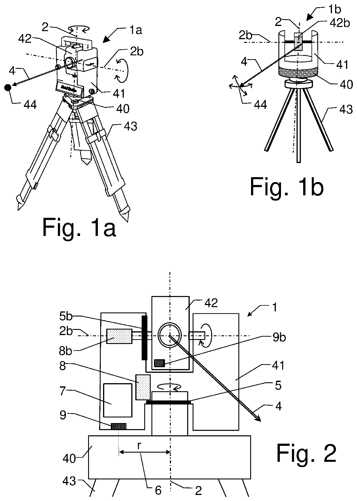
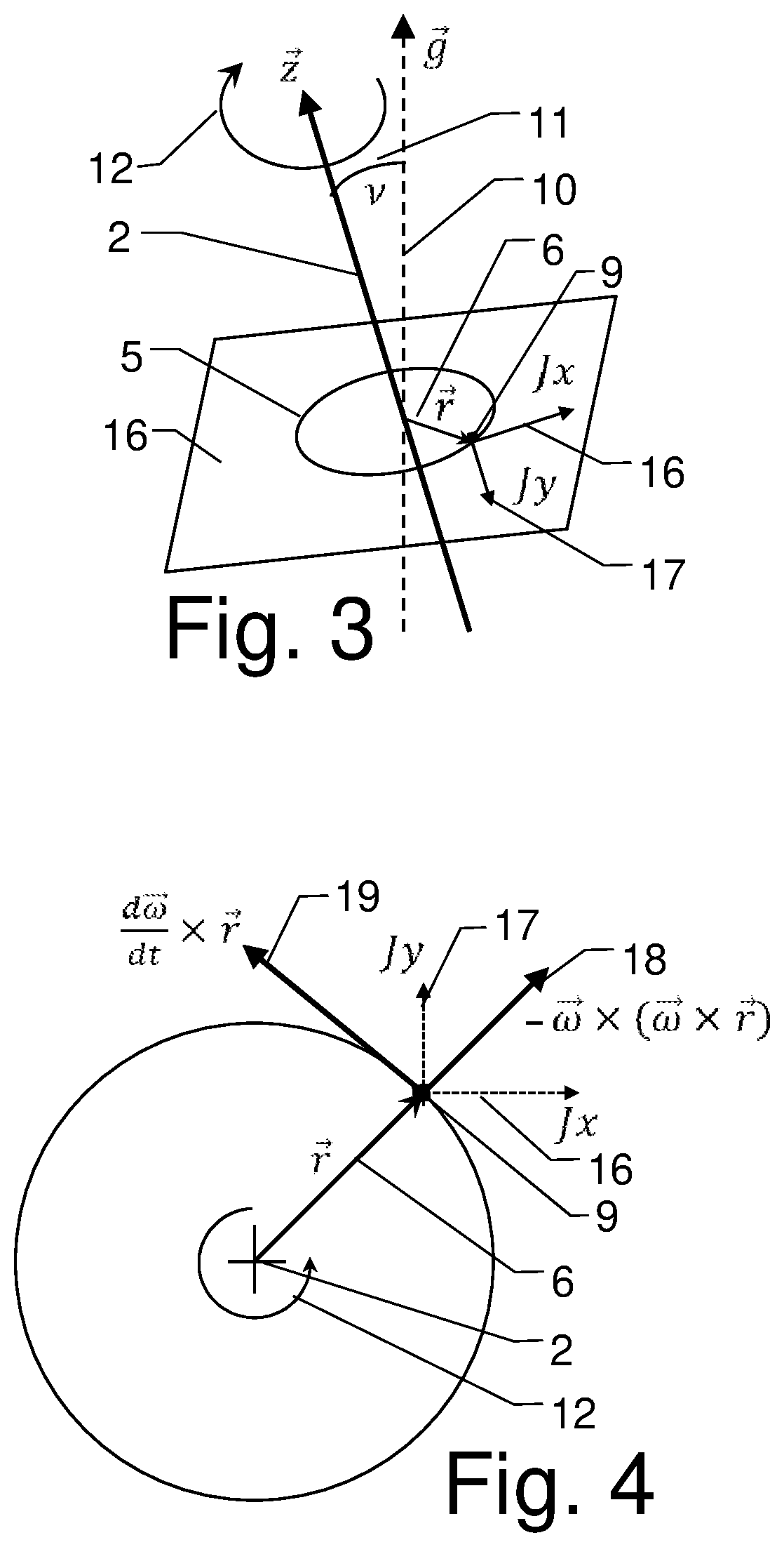
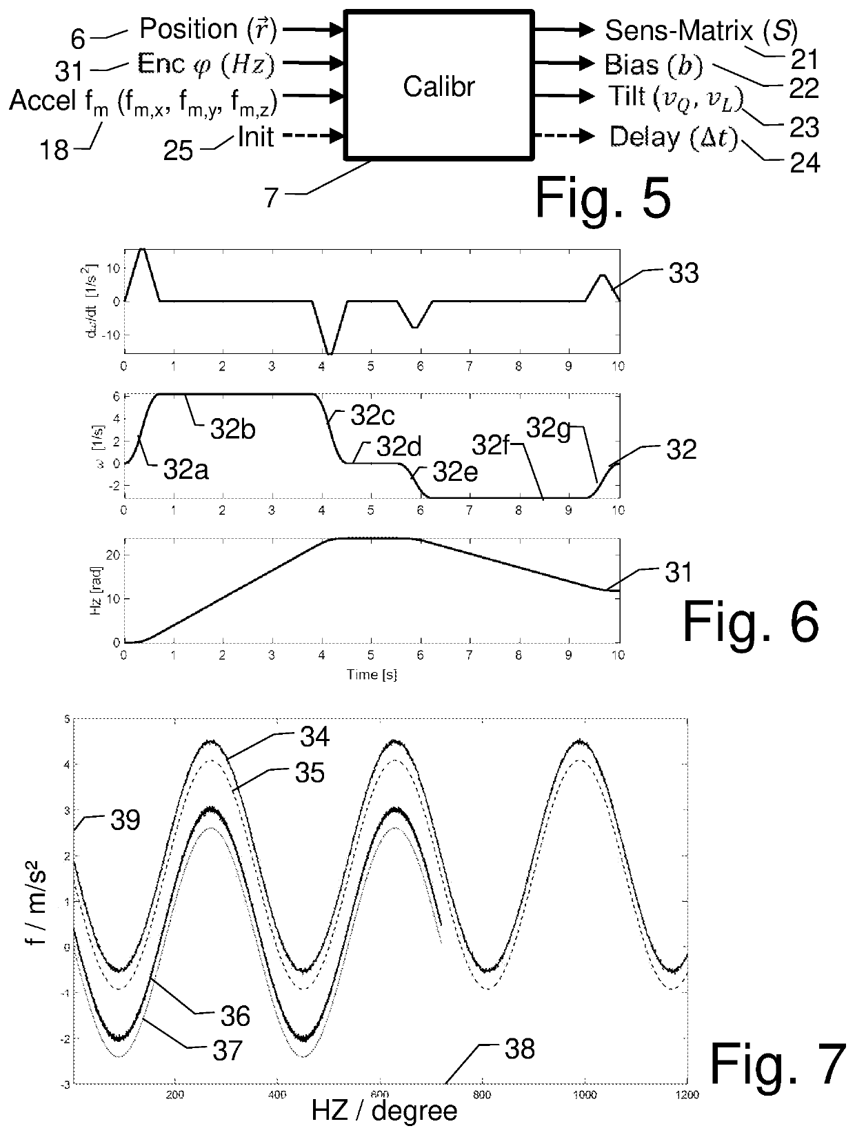
[0058]FIG. 1a shows an example of an embodiment of a geodetic surveying instrument 1 configured as a theodolite or total station 1a. In the shown example, the instrument 1 is stationed with its instrument base 40 on a tripod 43. It comprises a horizontal movement axis 2 around which an upp...


PUM


Abstract

A method for determining a calibrated leveling of a surveying instrument with an accelerometer. The method includes moving the accelerometer around a rotation axis of the instrument, the accelerometer being arranged at a known position from the rotation axis. As the accelerometer is moved, acquiring a movement profile of the movement by a rotational position encoder for the rotation axis and sensing an acceleration of the moving as accelerometer readings. Deriving at least one calibration parameter for the accelerometer readings is based on the movement profile, the known position and the corresponding accelerometer readings. A calibrated leveling is provided to the surveying instrument by applying the calibration parameter to the accelerometer readings.

Description

CROSS-REFERENCE TO RELATED APPLICATIONS[0001]This application claims priority to European Patent Application No. 19204967.4, filed on Oct. 23, 2019. The foregoing patent application is herein incorporated by reference.FIELD OF THE INVENTION[0002]The invention relates to a geodetic surveying instrument and an online calibration method of a surveying instrument.BACKGROUND[0003]In the technical field of surveying, in particular in the area of geodesy, construction work or industrial measurements, instruments for a contactless measurement by a movable optical measurement axis are used. By emitting optical radiation in a measurement direction towards a target point or target object to be measured, a spatial coordinate information of the target is derived. For example, an angular position and optionally also a distance—i.e. polar coordinates of the target object—can be derived and further processed, for example to derive Cartesian, Geodetic or Geospatial coordinate information. The measur...

Claims


Application Information

Patent Timeline
IPC IPC(8): G01C15/00G01C25/00
CPCG01C15/008G01C25/00G01C15/002G01C25/005
Inventor KOMPOSCH, SYBILLE VERENAWENK, MARKUSTÖNGI, PATRIK TITUSCELEBI, ISMAIL ROMANAEBISCHER, BEAT
Owner HEXAGON TECH CENT GMBH
Why Eureka
Try Eureka