Position determination on the basis of surroundings observations

a technology of positioning determination and surroundings, applied in the direction of instruments, navigation instruments, process and machine control, etc., can solve the problems of not being established ahead of time, affecting accuracy, and satellite-based navigation system not providing any direct information about spatial orientation

Pending Publication Date: 2022-08-11
ROBERT BOSCH GMBH
View PDF0 Cites 0 Cited by
  • Summary
  • Abstract
  • Description
  • Claims
  • Application Information

AI Technical Summary

Problems solved by technology

Multiple propagation in developed areas and shading of the visibility from the satellites, due to houses or trees, may impair the accuracy.
As a result, it is not established ahead of time which dominant features may be used for the recognition in the map.
For example, a satellite-based navigation system does not supply any direct information about the spatial orientation.
However, if the position determination was inactive for some time, for example because the vehicle or the robot was turned off, when the latter is started up again, it is not guaranteed that the orientation last ascertained is still correct.
The positions or poses ascertained using the different methods are, in particular, subject to different uncertainties if they are based on measured data collected using different physical measuring methods.
Similar uncertainties also exist when operating robots.
In this case, the tilting or bending could result in the object banging sideways against the warehouse floor, possibly damaging both the object and the shelf.
Prefabricated maps may be unavailable for company grounds or halls which are inaccessible to commercial suppliers of maps of this type.

Method used


Image

  • Position determination on the basis of surroundings observations
  • Position determination on the basis of surroundings observations
  • Position determination on the basis of surroundings observations

Examples


Embodiment Construction

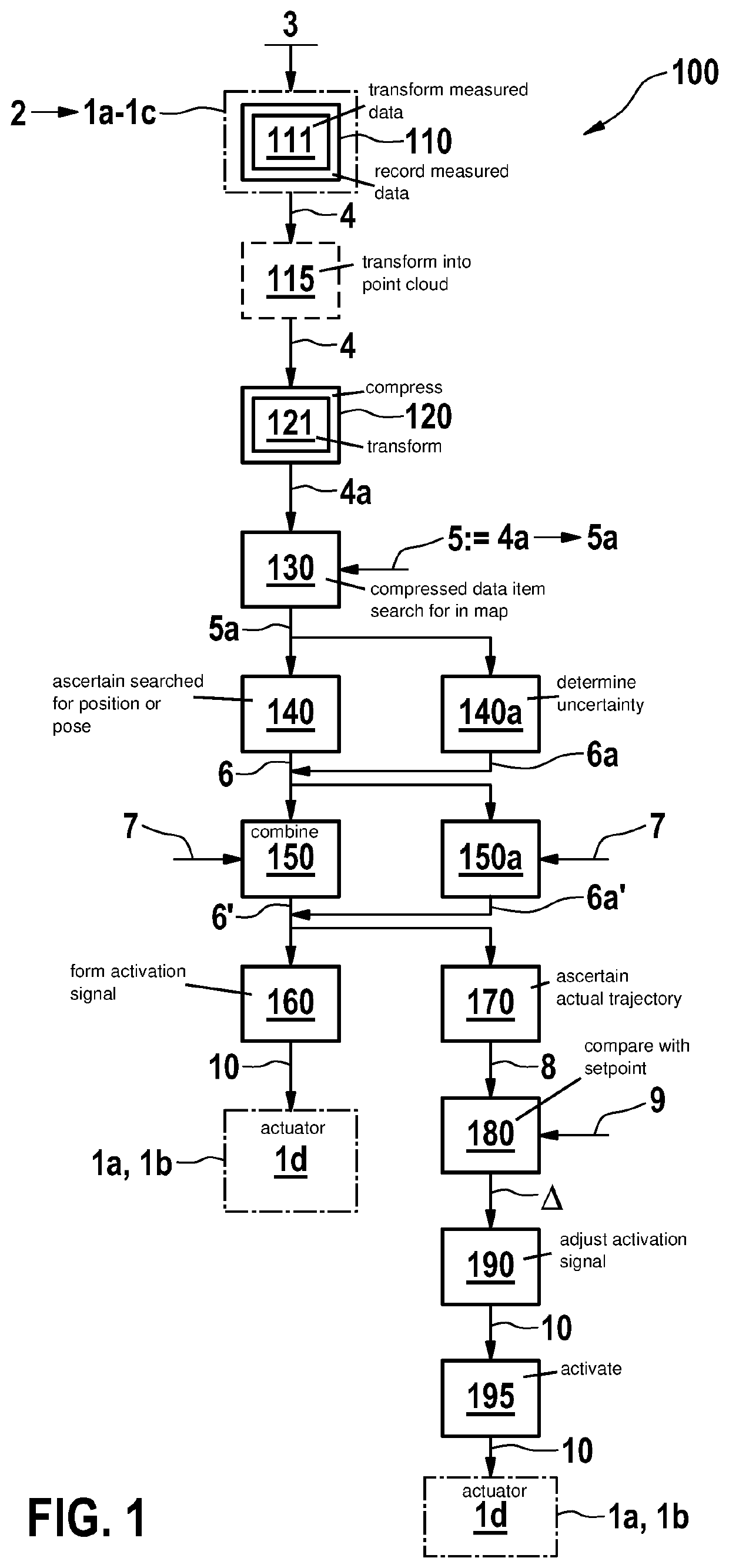
[0057]FIG. 1 shows a flowchart of an exemplary embodiment of method 100 for position determination. In step 110, measured data 4 are recorded from surroundings 2 of a vehicle 1a, a robot 1b or a mobile device 1c with the aid of at least one sensor 3 situated at vehicle 1a, at robot 1b or at mobile device 1c. According to block 111, these measured data 4 may be transformed into a coordinate system, in which map 5 used for the position determination is static. Measured data 4 may furthermore be optionally transformed into a point cloud in step 115.

[0058]In step 120, measured data 4 are compressed to form a compressed data item 4a. According to block 121, compressed data item 4a may, in turn, be transformed into a coordinate system, in which map 5 is static.

[0059]Map 5 assigns positions or poses 5a to compressed data items 4a. In step 130, compressed data item 4a is searched for in map 5. If the search is successful, position or pose 5a assigned to compressed data item 4a is used in st...


PUM


Abstract

A method for position determination. The method includes: recording measured data from the surroundings of a vehicle, robot, or mobile device, using at least one sensor situated on the vehicle, robot, and/or mobile device; compressing the measured data to form a compressed data item; searching for the compressed data item in a map, the map associating compressed data items at least with a position or pose in two- or three-dimensional space; in response to the compressed data item being found in the map, using the position or pose associated with the compressed data item by the map to ascertain the position or pose of the vehicle, robot, or mobile device. A method for creating a map for the position determination is also described.

Description

FIELD[0001]The present invention relates to a method, with the aid of which the position or pose of a vehicle, robot, or mobile device may be ascertained from observations of the surroundings independently of permanently installed infrastructure.BACKGROUND INFORMATION[0002]If vehicles and robots are to move autonomously, it is important that they are always correctly informed of their own position and orientation. This is the prerequisite for the trajectory planned for the autonomous movement being actually followed in reality, and the vehicle or the robot not colliding with objects which should not even be there according to its perception of the surroundings. Accuracies ranging from approximately 30 cm down to just a few centimeters are required here.[0003]Satellite-based navigation systems may supply accuracies of this type only under favorable reception conditions. Multiple propagation in developed areas and shading of the visibility from the satellites, due to houses or trees, ...

Claims


Application Information

Patent Timeline
Patent Type & Authority Applications(United States)
IPC IPC(8): G01S5/02G01C21/00G05D1/02
CPCG01S5/0294G01C21/3807G01C21/3841G01S5/0289G05D1/0212G01C21/30
Inventor VASKEVICIUS, NARUNASBIBER, PETER
Owner ROBERT BOSCH GMBH
Why Eureka
Try Eureka