Navigation information system

a technology of navigation information and navigation information, applied in navigation instruments, unauthorized memory use protection, instruments, etc., can solve the problems of large amount of fuel and time wasted, accidents can also be caused, and the navigation of a vehicle through an unfamiliar complex road network is a difficult task

Inactive Publication Date: 2000-08-29
BRITISH TELECOMM PLC
View PDF19 Cites 214 Cited by
  • Summary
  • Abstract
  • Description
  • Claims
  • Application Information

AI Technical Summary

Problems solved by technology

Navigation of a vehicle through an unfamiliar complex road network is a difficult task.
Large amounts of fuel and time are wasted as a result of drivers getting lost or using an inefficient route.
Accidents can also be caused by drivers attempting to read maps or complex road signs and losing concentration on the road ahead.
Moreover, a driver may choose an inefficient route as a result of using an out-of-date map.
An additional problem can occur even if a driver knows a route to his or her destination.
These systems would be very expensive.
The system is complex to operate, and could only be safely operated by the driver whilst the vehicle is stationary.
The latter approach can only collect data relating to users of the system, but has a lower capital cost.
However, at the beginning of a journey, a user cannot use the system until he encounters a beacon.
This proposed system allows instant updating of t

Method used


Image

  • Navigation information system
  • Navigation information system
  • Navigation information system

Examples


Embodiment Construction

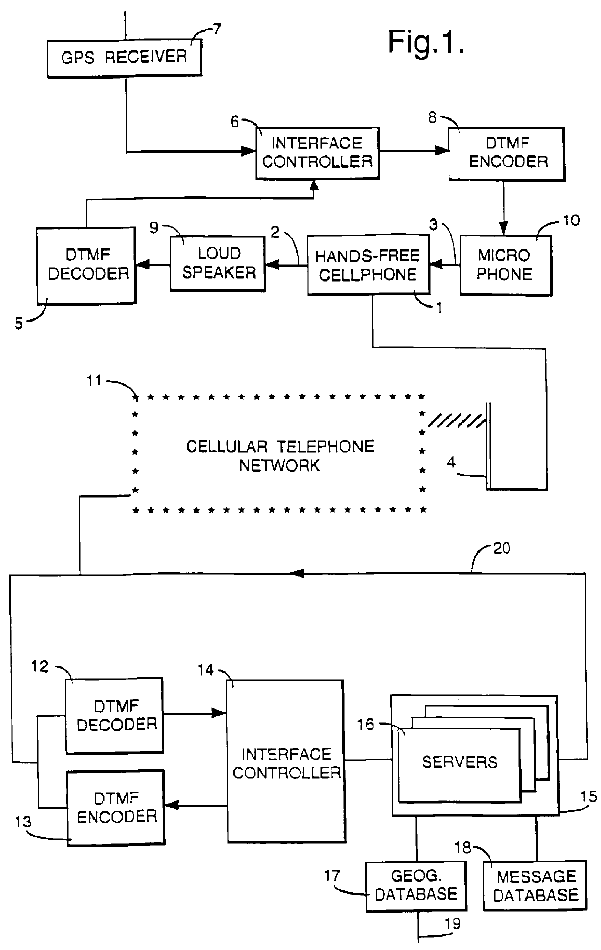
According to the embodiment of FIG. 1 the navigation system has a fixed part (comprising elements 12 to 19) and a number of mobile parts, of which one only is shown (comprising elements 1 to 10), interconnected by a cellular telephone network 11.

The mobile part comprises a mobile telephone 1 having an audio output 2, an audio input 3 and a radio antenna (transmit / receive) 4. The output 2 is connected to a decoder 5 to translate Dual-Tone Multi-Frequency (DTMF) signals received by the telephone 1 into data which is fed to an interface controller 6. The interface controller 6 also receives input from a GPS (Global Positioning System) satellite receiver 7. The interface controller transmits data to a DTMF encoder 8 which generates tones to be fed to the audio input of the mobile telephone. The audio output 2 and input 3 also include a loudspeaker 9 and microphone 10 respectively, to allow the telephone to be used for speech.

The fixed part comprises an interface with the cellular teleph...


PUM


Abstract

A navigation information system includes a communications system having a fixed part and at least one mobile part, the fixed part including data storage and processing for identifying the location of a mobile unit, generating guidance information appropriate to that location and transmitting it to the mobile unit. By locating most of the complexity with the service provider, in particular the navigation computer and geographical database, the system can be readily updated and the capital cost of the in-vehicle system, which in its simplest form may be a standard cellular telephone, can be minimized. The user makes a request for guidance information, and the system, having determined the user's present location, then transmits instructions to the user. The user's present location can be determined by a Satellite Positioning System.

Description

1. Field of the InventionThis invention relates to navigation information systems. It is particularly suitable for use in providing users of road vehicles with route guidance, but other applications are possible and are discussed below.2. Related ArtNavigation of a vehicle through an unfamiliar complex road network is a difficult task. Large amounts of fuel and time are wasted as a result of drivers getting lost or using an inefficient route. Accidents can also be caused by drivers attempting to read maps or complex road signs and losing concentration on the road ahead. Moreover, a driver may choose an inefficient route as a result of using an out-of-date map.An additional problem can occur even if a driver knows a route to his or her destination. That route may be congested or blocked as a result of accidents or maintenance work, so that an alternative route would be more efficient.Several proposals have been made for navigation guidance systems. In some such proposals a vehicle-bo...

Claims


Application Information

Patent Timeline
IPC IPC(8): G01C21/34G01S5/00G01S5/14G09B29/10G08G1/127G08G1/0967G08G1/0962G08G1/0968G01C21/00G01S19/09G01S19/41G01S19/48G01S19/49G06F12/14G06F21/62G08G1/09G08G1/137H04B7/26H04W28/00H04W88/02
CPCG01C21/34G01C21/3492G01S5/0027G01S19/09G01S19/48G01S19/49G08G1/096716G08G1/096741G08G1/096775G08G1/096811G08G1/096822G08G1/096861G08G1/096872G08G1/096883G08G1/096888G08G1/127G09B29/106G01S19/41G01S2205/002G01S2205/006G01S2205/008
Inventor MANNINGS, ROBIN THOMASWALL, NIGEL DAVID CHARLES
Owner BRITISH TELECOMM PLC
Why Eureka
Try Eureka