Using location data to determine traffic and route information

a technology of location data and traffic information, applied in the direction of instruments, navigation instruments, analogue processes for specific applications, etc., can solve the problems of not being frequently updated and only having traffic information available for certain roads

Inactive Publication Date: 2005-03-01
TRIMBLE NAVIGATION LTD
View PDF25 Cites 544 Cited by
  • Summary
  • Abstract
  • Description
  • Claims
  • Application Information

AI Technical Summary

Problems solved by technology

As a result, traffic information is available only for certain roads and is not frequently updated.

Method used


Image

  • Using location data to determine traffic and route information
  • Using location data to determine traffic and route information
  • Using location data to determine traffic and route information

Examples


Embodiment Construction

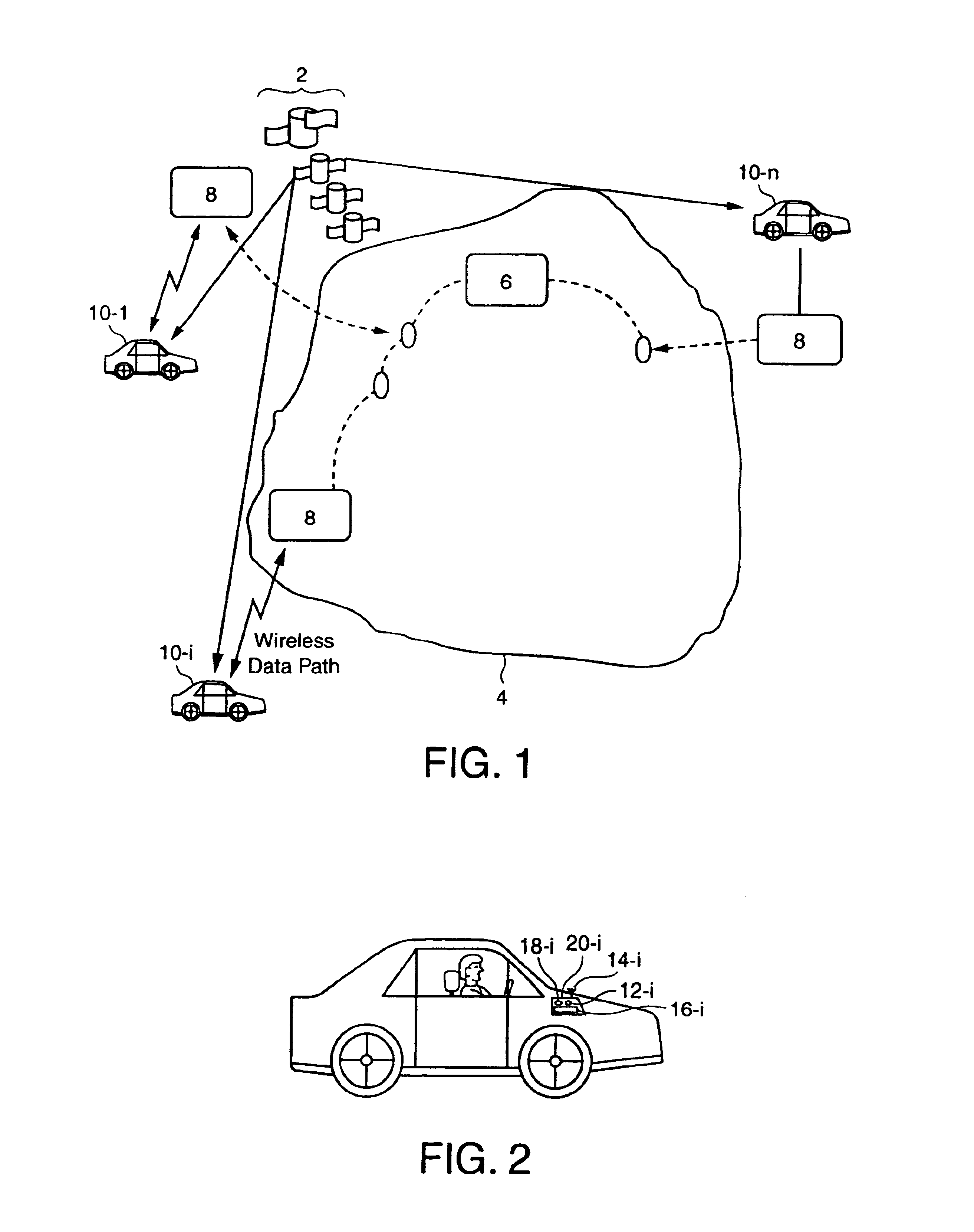
FIG. 1 provides an overview of one embodiment of the location-based traffic information system 1 in accordance with the present invention. The embodiment of FIG. 1 includes GPS satellites 2, data network 4, service computer 6, wireless communication network 8, and vehicles 10-l through 10-n. Vehicle 10-i is one of vehicles 10-l through 10-n, n being the number of vehicles that are part of traffic information system 1. Although FIG. 1 shows vehicles 10-l through 10-n as being automobiles, vehicle 10-i may be a truck, a motorcycle, a bus, a trailer, or any other vehicle. Data network 4 may be, for example, the Internet. Wireless communication network 8 may be but is not limited to CDPD, GPRS, GSM, iDEN, AMPS, 1XRTT, IEEE 802.11, or CDMA. Although the exemplary embodiment uses GPS satellites 2 to determine locations, any alternative location determining method can be used within the scope of the present invention.

As FIG. 2 shows, each vehicle 10-i is equipped with mobile unit 12-i. Mob...


PUM


Abstract

System and methods for determining and disseminating current traffic information and / or route information are presented. For example, in accordance with one embodiment of the present invention, traffic condition information is collected from mobile units that provide their location or position information. The traffic condition may be determined, for example, based on the difference between the velocity of each mobile unit and the speed limit corresponding to their location. Furthermore, the fastest routes between two locations may be determined and provided based on historical and / or current conditions and provided to a mobile unit. In accordance with another embodiment of the present invention, route information may be utilized to determine whether a mobile unit (e.g., associated with a vehicle) is allowed or prohibited from traveling along a certain route.

Description

BACKGROUND1. Field of the InventionThe invention relates to a system and a method for using location information to determine traffic conditions and / or route conditions or limitations such as, for example, limitations or rules pertaining to a location or a route.2. Discussion of the Related ArtMethods for determining the position of vehicles, airplanes, and ships include, for example, time difference of arrival (TDOA), angle of arrival (AOA), ray tracing / pattern recognition, global positioning system (GPS), and hybrid methods using network connections. Among the available methods, GPS includes a plurality of satellites orbiting the earth and sending out, at precisely synchronized times, a code sequence that identifies the satellite. Specifically, the code sequence transmitted by each satellite is a precisely timed binary pulse train. In addition to the code sequence, these satellites send out positioning information that can be used to calculate vehicle positions. A GPS receiver ret...

Claims


Application Information

Patent Timeline
Patent Type & Authority Patents(United States)
IPC IPC(8): G08G1/0968G08G1/01G01C21/34G01S19/48
CPCG01C21/3492G01C21/3691G08G1/0104G08G1/096811G08G1/096888G08G1/096838G08G1/096844G08G1/096872G08G1/096816
Inventor NAGDA, PARESHLI, WENBINHOWLETT, JULIAFAN, RODRIC C.YANG, XINNONGFAY, JAMES D.
Owner TRIMBLE NAVIGATION LTD
Why Eureka
Try Eureka