Ergonomic map information system

a map information system and ergonomic technology, applied in the field of ergonomic map information system, can solve the problems of excessive user attention, coarse representation, and coarse map portions, and achieve the effect of fast processing of graphic data

Inactive Publication Date: 2006-08-22
HARMAN BECKER AUTOMOTIVE SYST
View PDF7 Cites 14 Cited by
  • Summary
  • Abstract
  • Description
  • Claims
  • Application Information

AI Technical Summary

Benefits of technology

[0007]A system for the ergonomic representation of maps or portions of maps (“ergonomic map information system”) is presented. The ergonomic map information system may produce a representation of a map or portion of a map (individually and collectively referred to in this document as “map portions”) that may be intuitively understood by a user. The ergonomic map information system may include an interface, and an interface control unit. The interface control unit may include a processor, a memory, and a graphics control unit. The processor may control the operation of the ergonomic map information system. The interface may communicate the map portions with a user, and the graphics control unit may provide support to the interface by providing faster processing of graphic data.
[0009]The adaptation module may select colors with which to represent map contents. To avoid creating an undesirably strong color contrast between the colors of the background and the map information, the adaptation module may select colors for the map information and the background whereby the color of one of the map contents (such as map information or background) is selected dependent on the color of another of the map contents. For example, the adaptation module may automatically select colors for the map information and the background that are separated by no more than about 120 degrees on a hue circle. The adaptation module may select colors for additional information, such as road borders, which are located between the color of the map information and the color of the background on the hue circle. Further, the adaptation module may select a color for the additional information that is closer to the color of the map information than to the color of the map background on the hue circle. This allows the additional information to be perceived as associated with the map information. Further, the adaptation module may select colors for map information and additional information based on their type and / or relative importance.
[0011]The scale-dependent module may use scale-dependent color compensation, and / or scale-dependent road width variation to adapt the representations of roads and road borders so that they may be intuitively discernable by a user. Scale-dependent road width variation may include adjusting the width of map information, such as roads, according to road type and / or the scale of the map portion. Scale-dependent color compensation may include representing a type of map information with a uniform color. Further scale-dependent color compensation may include altering the intensity of a type of map information so that all map information of a given type may be subjectively perceived as uniform. For example, scale-dependent color compensation may increase the intensity of thin line representations of map information so that the thin line representations may be perceived as subjectively uniform with thick line representations of the same road type. Further, the scale-dependent color compensation may maintain or adapt the color impression of a road type with the scale of the represented map portion.
[0013]The smoothing module may improve the readability of map contents by smoothing the color transitions among map content elements. For example, anti-aliasing may be used to reduce the stair-step effect caused by a pixel-based display. Anti-aliasing may include mixing the foreground and the background colors of the pixels located in the transition area from one color to another color, and may be used to smooth color transitions between map information and additional map information, and / or between additional map information and the background

Problems solved by technology

Therefore, the representation may appear very coarse.
Therefore, map information systems may produce representations of map portions that appear very coarse and simple when compared with printed maps.
As a result, an excessive percentage of the user's attention may be devoted to interpreting the representation, and the user may not be able to grasp the map information intuitively.
These issues are compounded when the map information system is used by the driver of a vehicle.

Method used


Image

  • Ergonomic map information system
  • Ergonomic map information system
  • Ergonomic map information system

Examples


Embodiment Construction

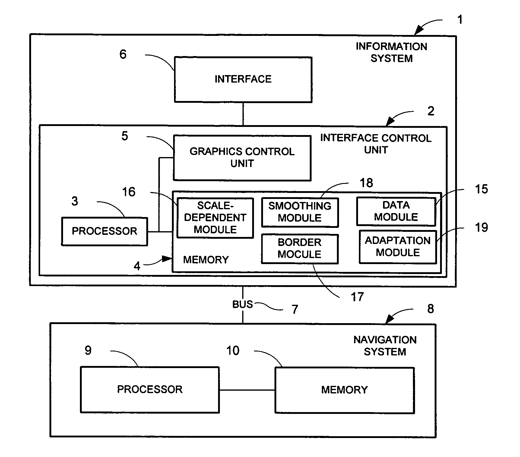
[0027]FIG. 1 depicts a system for the ergonomic representation of maps and / or portions of maps (“ergonomic map information system”) 1 in communication with a navigation system 8. The ergonomic map information system 1 may produce a representation of a map or portion of a map that may be intuitively understood by a user. The resulting map or map portion representation may increase the usefulness of the map or map portion. Further, if the ergonomic map information system 1 is implemented and used in a vehicle, the resulting ergonomic map representation may be less distracting for the driver. The ergonomic map information system 1 may include an interface 6, and an interface control unit 2. The interface control unit 2 may include a processor 3, a memory 4, and a graphics control unit 5 for controlling the interface 6. The processor 3 may control the operation of the ergonomic map information system 1. The interface 6 may communicate the map portions with a user. The graphics control u...


PUM


Abstract

A system for the ergonomic communication of a map portion is presented. The map portion may include map information, map background, and additional information. The system includes an interface control unit that may include a graphics control unit, a processor and a memory. The system may include one or more modules for creating an ergonomic presentation including: a border module that may add the additional information to the representation; an adaptation module for adapting the map information and map background and / or additional information with one another, such as within a maximum color contrast; a scale-dependent module that may adapt the color intensity and width of map information as a function of scale and type; and a smoothing module to increase the quality of the map portion representation. The system may include a method for controlling the representation of a map portion.

Description

PRIORITY CLAIM[0001]This application is a continuation of pending PCT Application No. PCT / EP03 / 06262, filed Jun. 13, 2003, which claims priority based on German Patent Application No. 102 26 885.1, filed Jun. 17, 2002. PCT Application No. PCT / EP03 / 06262 and German Patent Application No. 102 26 885.1 are incorporated herein by reference in their entirety.BACKGROUND OF THE INVENTION[0002]1. Technical Field[0003]The present invention relates to a system for the ergonomic representation of a map.[0004]2. Related Art[0005]Systems for presenting map information (“map information systems”), such as those that electronically present map information to a driver of a vehicle, may include a color thin film transistor (“TFT”) display for representing street maps, and an integrated navigation system for localizing the vehicle relative to the map. Map information systems may present maps or portions of maps (individually and collectively referred to in this document as “map portions”). These syst...

Claims


Application Information

Patent Timeline
Patent Type & Authority Patents(United States)
IPC IPC(8): G01C21/36G09B29/00G01C21/00G01C21/30G06T5/00G06T17/05G08G1/0969
CPCG08G1/0969G01C21/367
Inventor COCHLOVIUS, ELMARHUBER, GUNTHER
Owner HARMAN BECKER AUTOMOTIVE SYST
Why Eureka
Try Eureka