Land partition data generating method and apparatus

a technology of land partition and data generating method, applied in the field of land partition data generating method and apparatus, can solve the problems of dialog-based techniques, requiring much time and energy on the part of users, and achieve the effect of reducing the burden on users and high speed

Inactive Publication Date: 2006-10-24
HITACHI SOFTWARE ENG
View PDF14 Cites 34 Cited by
  • Summary
  • Abstract
  • Description
  • Claims
  • Application Information

AI Technical Summary

Benefits of technology

[0010]It is therefore an object of the invention to provide a method and apparatus for generating data concerning partitions of land such as farmland at, high speed while reducing the burden on the user.
[0017]The edge extraction step may comprise a process of evaluating the extracted edges and eliminating short edges.
[0021]The adjustment step may comprise a process of comparing the shape of an extracted rectangle with a predetermined land rectangle pattern and eliminating the data in a rectangle region with a shape that is unnatural as a land shape.

Problems solved by technology

As a result, this technique is inevitably dialog-based, requiring much time and energy on the part of the user.

Method used


Image

  • Land partition data generating method and apparatus
  • Land partition data generating method and apparatus
  • Land partition data generating method and apparatus

Examples


Embodiment Construction

[0041]The invention will be described by way of an embodiment with reference made to the drawings.

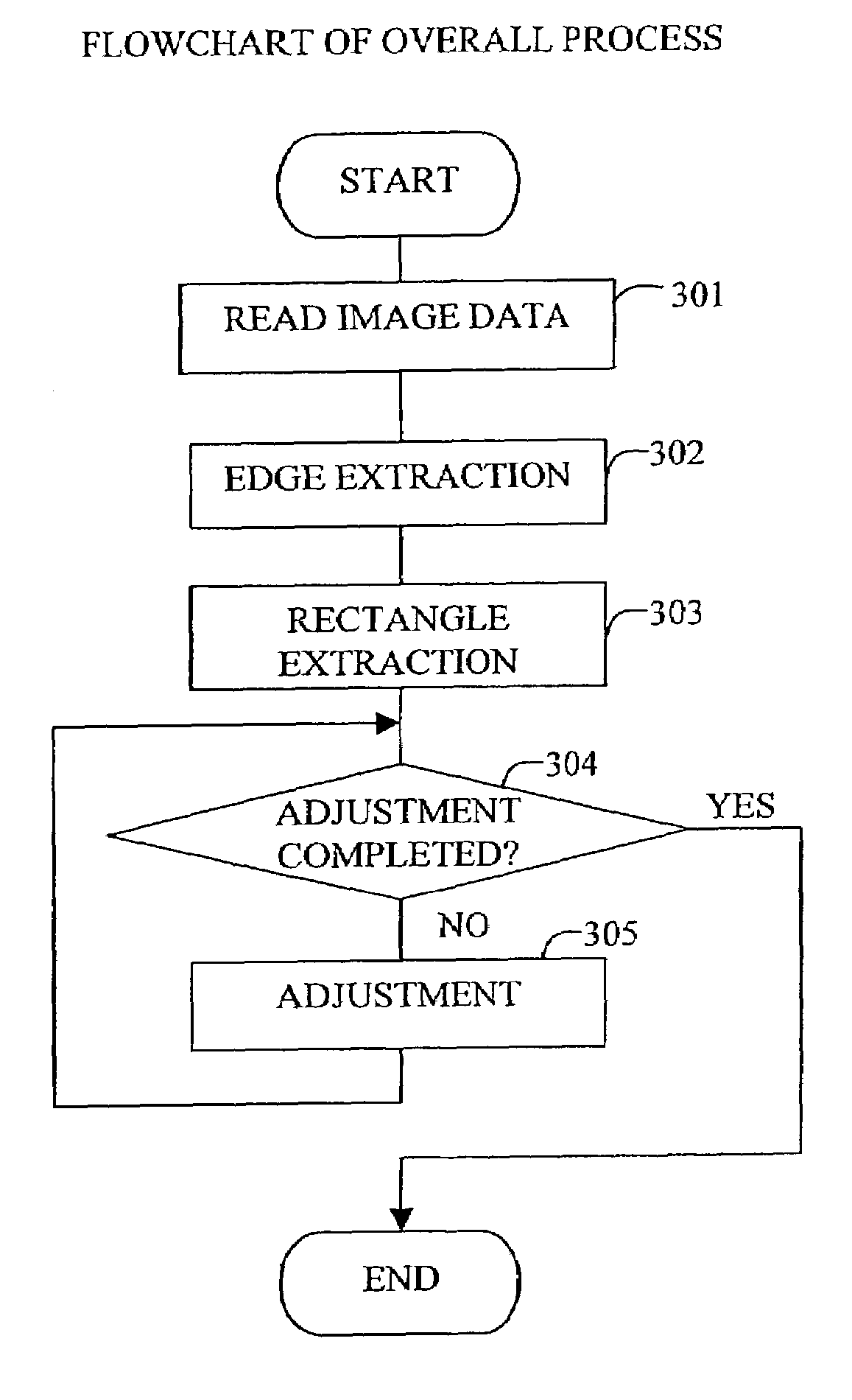
[0042]In the present embodiment, information concerning an ground image photographed by a high-altitude flying vehicle such as a satellite or airplane is fed to a land partition-data generating apparatus. The apparatus automatically examine the information to recognize a partition of land such as farmland and display an alert about unnatural portions. The apparatus then performs a fine-adjustment process in accordance with user inputs, and finally outputs rectangle information concerning the land partition.

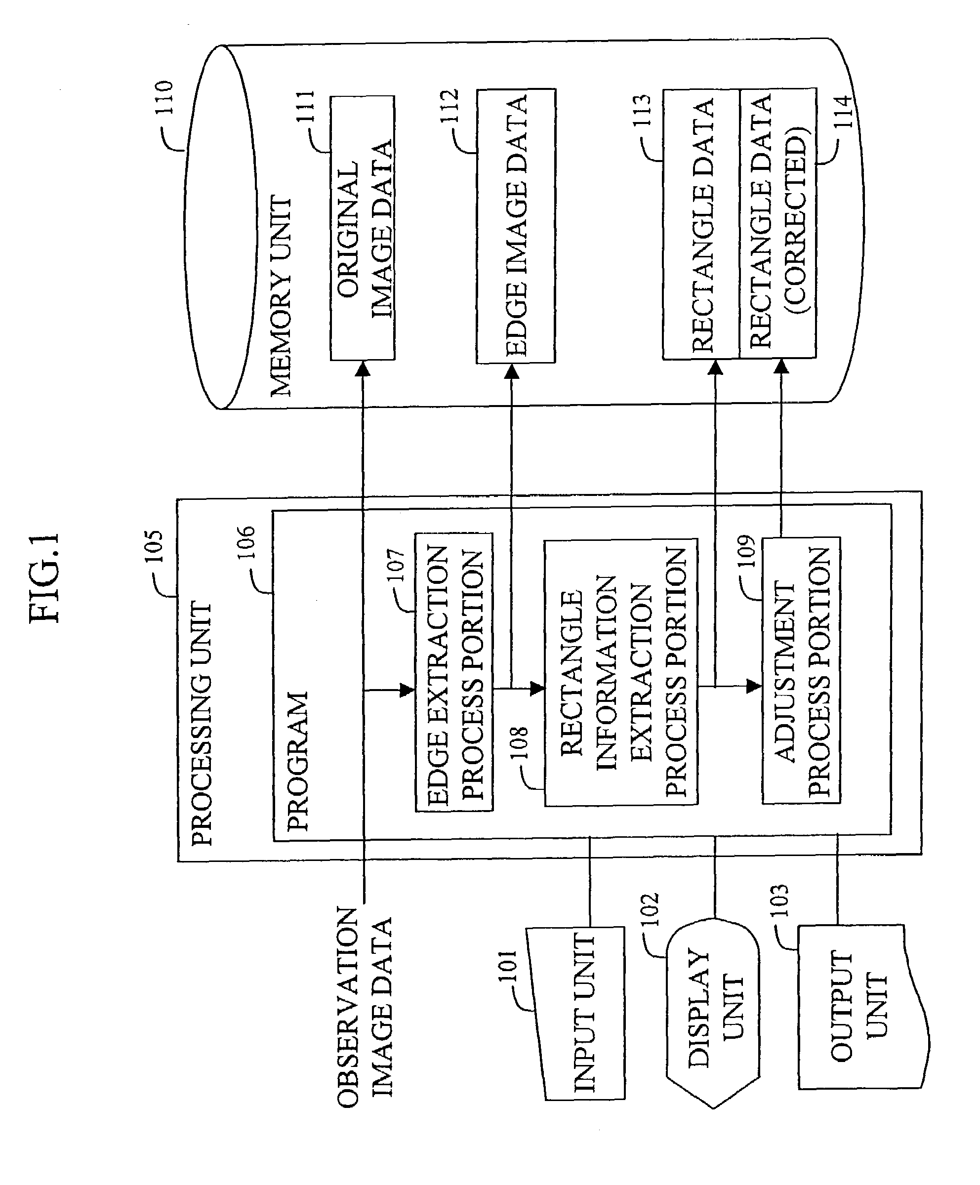
[0043]FIG. 1 shows a block diagram of the land partition data generating apparatus according to the embodiment of the invention.

[0044]The apparatus includes an input unit 101, a display unit 102, an output unit 103 such as a printer, a processing unit 105 and a memory unit 110.

[0045]The processing unit 105 runs a program 106 including an edge extraction process 107, a rectangle inform...


PUM


Abstract

A method and apparatus generates data concerning a partition of land such as farmland based on an observation image of the surface of the earth photographed by a high-altitude flying vehicle such as a satellite or airplane at high speed while reducing the burden on the user. The method comprises the steps of extracting edges in the observation image; extracting a rectangle region on the image by determining and connecting points of intersection of a plurality of straight lines extending radially from a point on the image and the edges; and adjusting the extracted rectangle region by refining and correcting it.

Description

BACKGROUND OF THE INVENTION[0001]1. Technical Field[0002]The present invention relates to a method and apparatus for generating data concerning partitions of land by analyzing an ground image photographed at high altitude by a high-altitude flying vehicle such as a satellite or an airplane.[0003]2. Background Art[0004]Satellite and aerial photography is becoming increasingly common. Various techniques are being developed for creating maps or analyzing the land surface, for example, based on images provided by the photography.[0005]In particular, in order to analyze photographs of a farming area, a method is required for recognizing farmland partitions within an image.[0006]A farmland partition is usually recognized by extracting from an image a polygon (to be hereafter referred to as a rectangle) enclosed by edges indicating farmland. As an example of the prior art for recognizing a rectangle in an image, JP Patent Publication (Unexamined Application) No. 11-266373 discloses an imag...

Claims


Application Information

Patent Timeline
Patent Type & Authority Patents(United States)
IPC IPC(8): G06K9/48G06K9/00G06T1/00G06K9/34G06T5/00G06T5/20G06T7/60
CPCG06T7/0083G06T7/606G06T2207/10032G06T2207/20168G06T2207/30188G06T7/12G06T7/66
Inventor KUBOTA, SENONOYAMA, TAKASHI
Owner HITACHI SOFTWARE ENG
Why Eureka
Try Eureka