Automatic vehicle guidance method and system

a vehicle guidance and automatic technology, applied in the direction of navigation instruments, external condition input parameters, non-deflectable wheel steering, etc., can solve the problems of requiring a great installation effort for the installation of magnetic markers in the roadway, and the information content conveyed by the markers can be changed later only with a great effort, so as to achieve a flexible manner, reduce the effect of installation effort and increase the safety of traffi

Inactive Publication Date: 2008-01-08
ROBERT BOSCH GMBH
View PDF16 Cites 69 Cited by
  • Summary
  • Abstract
  • Description
  • Claims
  • Application Information

AI Technical Summary

Benefits of technology

[0008]One advantage of the present invention is that the infrastructure data can be adapted to changed conditions with very small effort and in an extremely flexible manner. Thus, for example, relocation of lanes or lane constrictions at construction sites can be accommodated by simply changing the infrastructure data. In this manner, traffic safety can be considerably increased especially in the area of construction sites by fully automatic lateral guidance or by a lane-keeping assistance system which only aids the driver.
[0009]The method according to the present invention allows a variety of enhancements. For example, the infrastructure data can also contain information about the uphill grade or downhill grade of the roadway, which enables improved longitudinal guidance. Moreover, the infrastructure data can also act as virtual traffic signs by containing information about road-related restrictions such as speed limits, prohibited passing, or the like, or warnings of particular danger spots. The automatic vehicle guidance system can either directly apply this information, for example, by automatically reducing the setpoint speed in the case of speed limits or warnings of danger, by automatically blocking an automatic passing algorithm, if implemented in the vehicle, in the case of prohibited passing (such as for trucks on expressways), or the like, or the information can be communicated to the driver by synthetic speech output.
[0010]The infrastructure data may be provided by a central server, or by decentralized servers distributed over the road network, and is loaded into the memory of the vehicle via a radio link before the automatic vehicle guidance is started. The radio link can be, for example, a mobile radio link such as GSM or UMTS, or a broadcast link such as DAB, DMB, and the like. Then, the data that is relevant for determining the currently valid setpoint values is selected from the stored infrastructure data on the basis of the position data provided by the position system. At the same time, the position data provides the actual values for lateral guidance, i.e., for example, the current deviation of the vehicle from the center of the lane. Then, by setpoint / actual value comparison, it is possible to either directly generate a corresponding control command for the steering system, or to issue a warning to the driver, informing him / her of the necessity of a steering intervention.
[0011]For a sufficiently accurate setpoint / actual value comparison, the position system may need to have a resolution on the order of several decimeters or better, which is not yet attainable by the conventional GPS system. However, position systems that are capable of achieving the required resolution, such as DGPS or GALILEO, are being planned or already under construction. In general, the position system can be a satellite-based system or, optionally, also a system based on terrestrial radio stations, such as mobile radio base station.
[0012]The present invention is advantageous in combination with a navigation system. In this case, the precise position system required for the method according to the present invention can also be used by the navigation system. Conversely, the audible and graphical output devices of the navigation system can be used by the vehicle guidance system. Moreover, the precalculation of the travel route by the navigation system offers the possibility of selectively downloading the infrastructure data for this travel route or for the next section of this travel route.
[0013]If no navigation system is present, or in the case that the driver does not use the navigation system because he / she knows the route, provision may be made for a mode in which the infrastructure data for the current surroundings of the vehicle is automatically loaded into the on-board memory. The selection of these surroundings may be dependent on the direction of travel and includes, for example, the data for the currently traveled road up to the next possible turn as well as the data for the initial sections of all roads that can be traveled from this possible turn. When the vehicle reaches the next possible turn and the driver decides on one of the possible routes, then there is still enough time to download the infrastructure data for the next vehicle surroundings. Thus, it can be ensured that the required infrastructure data is provided in its entirety even if the destination is unknown to the system.

Problems solved by technology

However, installation of the magnetic markers in the roadway requires very great installation effort, and the information content conveyed by the markers can be changed later only with very great effort.

Method used


Image

  • Automatic vehicle guidance method and system
  • Automatic vehicle guidance method and system

Examples


Embodiment Construction

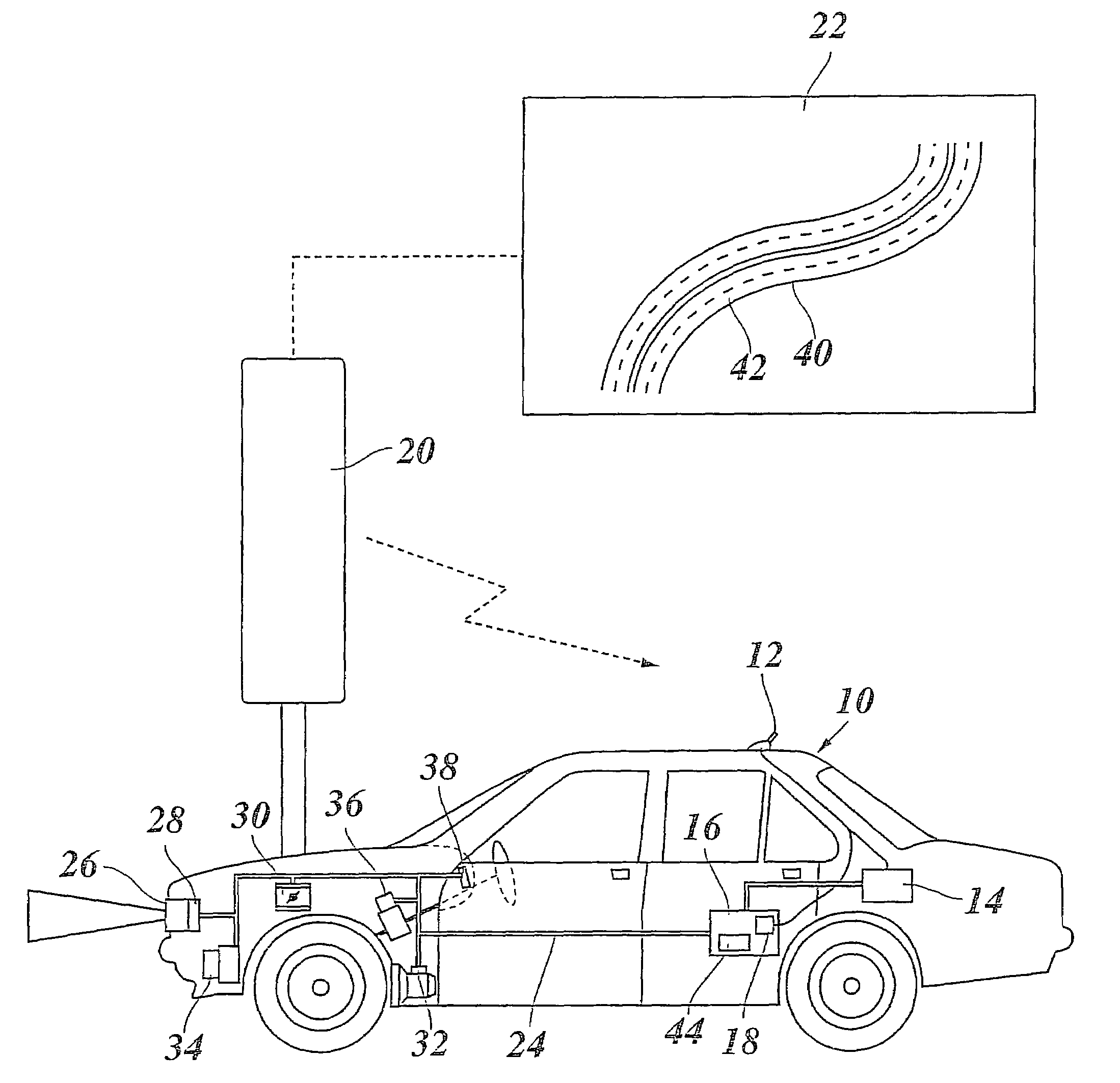
[0020]As shown in the FIGURE, motor vehicle 10 has an antenna 12, a position system 14, such as a DGPS receiver, and a guidance unit 16 constituted by a microcomputer or another electronic data processing system. Antenna 12 can be a multi-purpose antenna which, on one hand, is connected to position system 14 and, on the other hand, to a mobile radio interface 18 of guidance unit 16. Via antenna 12, position system 14 receives satellite signals for high-precision satellite navigation with a spatial resolution of at least several decimeters. Via mobile radio interface 18 and antenna 12 and a mobile radio network 20, here symbolized by a radio beacon, the guidance unit communicates with a server 22 in which is stored traffic infrastructure data about the road network at least for the region in which vehicle 10 is located.

[0021]Moreover, guidance unit 16 is connected to position system 14 and to further system components of vehicle 10 via a data bus (such as a CAN bus). In the example s...


PUM


Abstract

A method for automatic vehicle guidance is provided, in which infrastructure data is wirelessly transmitted to the vehicle and vehicle guidance commands are calculated on the basis of the infrastructure data. In this method, the infrastructure data for at least a section of the travel route immediately ahead is loaded into an on-board memory, the current position of the vehicle is continuously determined using a precise position system, and the commands are calculated on the basis of the position data and the stored infrastructure data.

Description

BACKGROUND INFORMATION[0001]The present invention relates to a method for automatic vehicle guidance, in which infrastructure data is wirelessly transmitted to the vehicle and vehicle guidance commands are calculated on the basis of the infrastructure data, and to a system for carrying out this method.BACKGROUND INFORMATION[0002]For motor vehicles, speed control systems are known which allow the speed of the vehicle to be controlled to a desired speed selected by the driver. Moreover, it is possible to measure the distance from a vehicle ahead using a distance sensor, for example, using as a radar or lidar sensor. Then, the speed control is modified in such a manner that a predetermined, e.g., speed-dependent distance from the vehicle ahead that is selected as the target object is maintained. Such systems, which are also referred to as adaptive speed control systems or ACC (adaptive cruise control) systems, allow automatic longitudinal vehicle guidance under suitable conditions by i...

Claims


Application Information

Patent Timeline
Patent Type & Authority Patents(United States)
IPC IPC(8): G08G1/09B60K31/00G06F17/00G01C21/00B60R21/00B60W10/00B60W10/04B60W10/20B62D6/00B62D15/02B62D101/00B62D133/00F02D29/02G01C21/34G08G1/0967G08G1/0968G08G1/0969
CPCB60K31/0008B60K31/0058B60W30/16B62D15/026G01C21/26G08G1/096725G08G1/096741G08G1/096775G08G1/096827G08G1/096844B60T2201/08B60T2201/083B60T2201/087B60W2550/14B60W2550/142B60W2550/22B60W2550/402B60W2552/00B60W2555/60B60W2556/50B60W2552/15B60W30/18159B60W2552/10B60W2552/30
Inventor DIETERLE, WERNER
Owner ROBERT BOSCH GMBH
Why Eureka
Try Eureka