Mobile autonomous updating of GIS maps

a technology of gis and map, applied in the direction of process and machine control, navigation instruments, instruments, etc., can solve the problems of difficult to distinguish features, many physical objects are out of satellite view, and difficult to automatically distinguish them using software image analysis

Active Publication Date: 2011-03-22
ACTIVMEDIA ROBOTICSMOBILEROBOTS +1
View PDF7 Cites 117 Cited by
  • Summary
  • Abstract
  • Description
  • Claims
  • Application Information

AI Technical Summary

Problems solved by technology

While some features and their attributes can be imaged from satellites very efficiently, many physical objects are out of satellite view.
Even where features are in view, it can be difficult to distinguish those features in a satellite view, and it is especially difficult to distinguish them automatically using software image analysis, for example.
These methods can be expensive and time consuming, so most GIS data tends to be acquired once, and is updated rarely, if ever.

Method used


Image

  • Mobile autonomous updating of GIS maps
  • Mobile autonomous updating of GIS maps
  • Mobile autonomous updating of GIS maps

Examples


Embodiment Construction

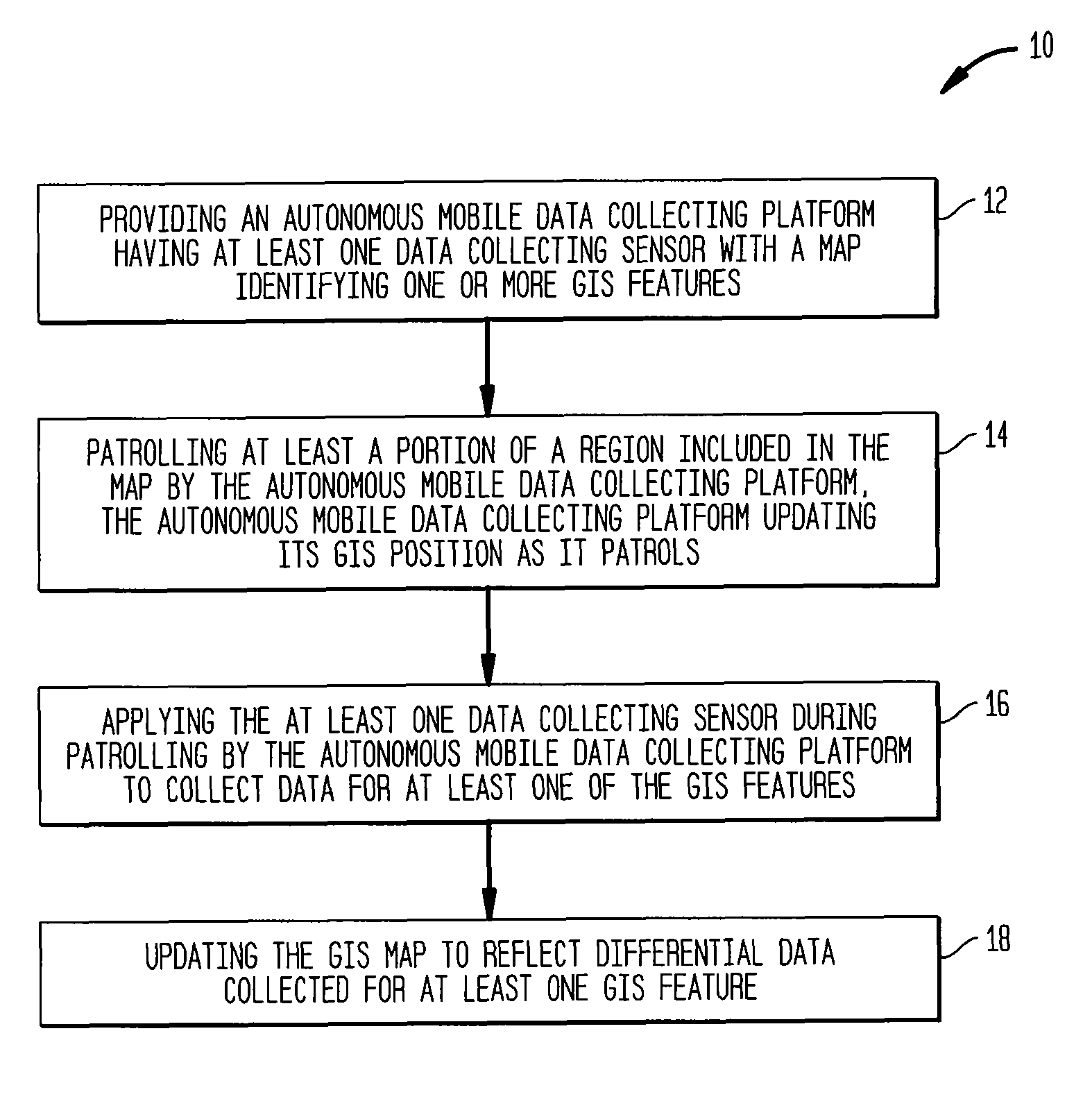
[0018]An exemplary method 10 for mobile autonomous updating of a map in a universal uniform spatial reference frame, such as the GIS reference frame, is illustrated in FIG. 1. As used herein, GIS refers to Global Information System, a generic term for a spatial database in which the spatial information is linked to GPS coordinates. Similarly, GPS refers to the Global Positioning System in which satellite-based radio systems, typically satellite-based, provide three-dimensional position and time information to which suitably equipped receivers anywhere on or near the surface of the Earth compute their global position, velocity and orientation (heading). While GIS is used as the preferred universal uniform spatial reference frame, it should be understood from the description that other spatial reference frames are possible.

[0019]In step 12 in the illustrated method 10, an autonomous mobile data collecting platform is provided with a map having one or more GIS features with the autonom...


PUM


Abstract

A method for mobile autonomous updating of GIS maps is provided. In the method, an autonomous mobile data collecting platform is provided with a map identifying one or more GIS features. The platform has at least one data collecting sensor for collecting data for at least one of the GIS features and patrols at least a portion of a region included in the map while updating its GIS position as it patrols. The autonomous mobile data collecting platform applies the at least one data collecting sensor during patrolling to collect data for at least one of the GIS features and updates the GIS map to reflect differential data collected for at least one GIS feature.

Description

RELATED APPLICATIONS[0001]This application claims priority to U.S. Provisional Patent Application Ser. No. 60 / 742,160, filed on Dec. 1, 2005 and entitled “Mobile Autonomous GIS Updating Method,” which application is incorporated herein by reference in its entirety.BACKGROUND OF THE INVENTION[0002]Creating spatial representations of the world for use in decision-making, navigation and many other applications, has grown into an enormous GIS (Geographical Information System, or sometimes, Global Information System) that links natural and man-made features with their relative and unique 3-D positions on or near Earth. Data include Earth topography and vegetation, as mostly gathered by satellite imagery. Other Features, such as the centerline of a road, are gathered by driving a vehicle with a GPS (Global Positioning System) system and noting the location of intersections and waypoints. Utility locations are input by surveying with GPS. Collected into GIS databases, the data subsequently...

Claims


Application Information

Patent Timeline
Patent Type & Authority Patents(United States)
IPC IPC(8): G06G7/78
CPCG01C21/20G05D1/024G05D1/0274G05D1/0261G05D1/0272G05D1/0278G05D2201/0207
Inventor DIETSCH, JEANNEKENNEDY, WILLIAMLAFARY, MATTHEW
Owner ACTIVMEDIA ROBOTICSMOBILEROBOTS
Why Eureka
Try Eureka