Navigation data configuration for optimal time to first fix

a technology of navigation data and optimal time, applied in the direction of satellite radio beaconing, measurement devices, instruments, etc., can solve the problems of multiple delays, complex satellite navigation receivers, and high deployment costs

Active Publication Date: 2017-05-02
ACCORD SOFTWARE & SYST PVT
View PDF8 Cites 2 Cited by
  • Summary
  • Abstract
  • Description
  • Claims
  • Application Information

AI Technical Summary

Benefits of technology

[0022]The method and the system disclosed herein address the above mentioned needs for generating a navigation data structure with a few sub-frames, for example, three sub-frames, configuring navigation data in these sub-frames to selectively accommodate navigation data, and selectively transmitting the generated navigation data structure with the configured navigation data to a satellite navigation receiver in reduced time to enable faster access to the navigation data and to reduce time to first fix (TTFF) for civilian users and restricted users. The method and the system disclosed herein provide a signal generation system, for example, in each of multiple satellites of a constellation. The signal generation system generates a navigation signal comprising a navigation data structure. The navigation data structure is configured to selectively accommodate navigation data. The navigation data structure disclosed herein comprises a first sub-frame, a second sub-frame, and a third sub-frame. The signal generation system configures the first sub-frame and the second sub-frame to accommodate selective ephemeris data of the navigation data. The configuration of the first sub-frame and the second sub-frame reduces time for collecting the ephemeris data by the satellite navigation receiver. The signal generation system configures the third sub-frame to accommodate a text message comprising almanac data, ionospheric data, coordinated universal time (UTC) data, textual data, for example, user defined data, and any combination thereof. The configuration of the third sub-frame reduces time for collecting the almanac data, the ionospheric data, the UTC data, and the textual data by the satellite navigation receiver.
[0024]The signal generation system selectively groups the almanac data, the ionospheric data, and the coordinated universal time (UTC) data. For example, the signal generation system groups the UTC data with the ionospheric data, or the almanac data with the ionospheric data. In an embodiment, the signal generation system verifies integrity of the navigation data in the first sub-frame, the second sub-frame, and the third sub-frame of the generated navigation data structure for determining accuracy of the navigation data. The signal generation system selectively transmits the ephemeris data, the selectively grouped almanac data, ionospheric data, and UTC data, and the textual data in the generated navigation data structure to the satellite navigation receiver. The signal generation system alternatively transmits the ionospheric data and the UTC data with the almanac data and free of the almanac data in the third sub-frame in the generated navigation data structure to transmit the navigation data in reduced time, thereby reducing the TTFF in the satellite navigation receiver. Furthermore, the method and the system disclosed herein enable each of the satellites of a constellation to simultaneously and selectively transmit the selective ephemeris data, the selectively grouped almanac data, ionospheric data, and UTC data, and the textual data in the generated navigation data structure to the satellite navigation receiver, thereby allowing the satellite navigation receiver to collectively receive the selective ephemeris data, the almanac data, the ionospheric data, the UTC data, and the textual data in reduced time, thereby further reducing the TTFF in the satellite navigation receiver.
[0025]In an embodiment for reducing TTFF in a satellite navigation receiver in a single frequency of operation, the signal generation system configures the third sub-frame of the generated navigation data structure to accommodate a text message having only the ionospheric data and the coordinated universal time (UTC) data. The configuration of the third sub-frame reduces time for collecting the ionospheric data and the UTC data by the satellite navigation receiver. In an embodiment, the signal generation system determines a mode of operation for transmitting the navigation data in the generated navigation data structure. The mode of operation is, for example, a civilian mode or a restricted mode. The signal generation system transmits the ephemeris data, the ionospheric data, and the UTC data free of the almanac data in the generated navigation data structure to the satellite navigation receiver in the determined mode of operation, thereby reducing the TTFF in the satellite navigation receiver. The ionospheric data and the UTC data are transmitted by one of multiple satellites of a constellation to the satellite navigation receiver. Furthermore, in this embodiment, the signal generation system alters transmission of the navigation data after the transmission of the ionospheric data and the UTC data to further reduce the TTFF in the satellite navigation receiver.
[0026]In the civilian mode of operation, the signal generation system staggers the navigation data in each of the sub-frames of the generated navigation data structure into a first portion and a second portion. In an embodiment, the signal generation system determines a mode of service, for example, a civilian mode of service, a restricted mode of service, etc., for transmitting the staggered navigation data in the generated navigation data structure. Each of multiple satellites of a constellation parallelly transmits each of the sub-frames of the generated navigation data structure comprising distinct staggered navigation data over a first carrier frequency, for example, the L5 frequency, and a second carrier frequency, for example, the S1 frequency in the determined mode of service to obtain the navigation data in reduced time, thereby reducing the TTFF in the satellite navigation receiver in the civilian mode of operation.
[0028]In the restricted mode of operation, the signal generation system staggers the navigation data in each of the sub-frames of the generated navigation data structure into a first portion and a second portion. In an embodiment, the signal generation system determines a mode of service, for example, a civilian mode of service, a restricted mode of service, etc., for transmitting the staggered navigation data in the generated navigation data structure. Each of the satellites of a constellation parallelly transmits each of the sub-frames over a first carrier frequency, for example, the L5 frequency, and a second carrier frequency, for example, the S1 frequency in the determined mode of service to obtain the navigation data in reduced time, thereby reducing the TTFF in the satellite navigation receiver in the restricted mode of operation. The signal generation system parallelly transmits each of the sub-frames by: sequentially transmitting the first portion and the second portion of each of the sub-frames over the first carrier frequency, and a complementary of the first portion and the second portion of each of the sub-frames over the second carrier frequency in a first mode of service, for example, the civilian mode of service to obtain time of week (TOW) data; sequentially transmitting the second portion of one sub-frame and the first portion of another sub-frame, and a complementary of the second portion of one sub-frame and the first portion of the other sub-frame over the first carrier frequency in a second mode of service, for example, the restricted mode of service; and sequentially transmitting the first portion of one sub-frame and the second portion of another sub-frame, and a complementary of the first portion of one sub-frame and the second portion of the other sub-frame over the second carrier frequency in the second mode of service, for example, the restricted mode of service. The first mode of service assists the second mode of service for availing the obtained TOW data in reduced time, thereby reducing the TTFF in the satellite navigation receiver.

Problems solved by technology

However, these methods are generally expensive in terms of deployment costs, complexity of the satellite navigation receiver, etc.
The delay in collecting the navigation data translates to multiple delays, for example, delays in computing satellite visibility, delays in estimation of ionosphere delay estimation coefficients, delays in cross-correlation detection based on the range estimated using the almanac data and an integrity check specified by the federal aviation administration (FAA) for beta-3 civil aviation receivers, etc.
Conventional satellite navigation receivers take a relatively long time, for example, about 12.5 minutes to collect the almanac data for a single frequency user.
This constrains the time taken for the collection of the ephemeris data and delays the TTFF.
This delays the ionosphere error computation and thus delays accurate positioning in a satellite navigation receiver.
Moreover, parameters such as UTC parameters compound the delay and bandwidth overhead since the UTC parameters need not be transmitted very frequently for computation of the user's position.
However, Galileo uses a navigation data structure with a larger number of sub-frames and imposes constraints in terms of memory requirements and an increased amount of time required for transmitting the complete navigation data structure.
This increases the time overhead in almanac transmission and increases the almanac data collection time at the satellite navigation receiver, thereby delaying ionosphere estimation at the satellite navigation receiver.
An increased data rate necessitates more signal transmission power, which is a costly proposition onboard satellites.

Method used


Image

  • Navigation data configuration for optimal time to first fix
  • Navigation data configuration for optimal time to first fix
  • Navigation data configuration for optimal time to first fix

Examples


Embodiment Construction

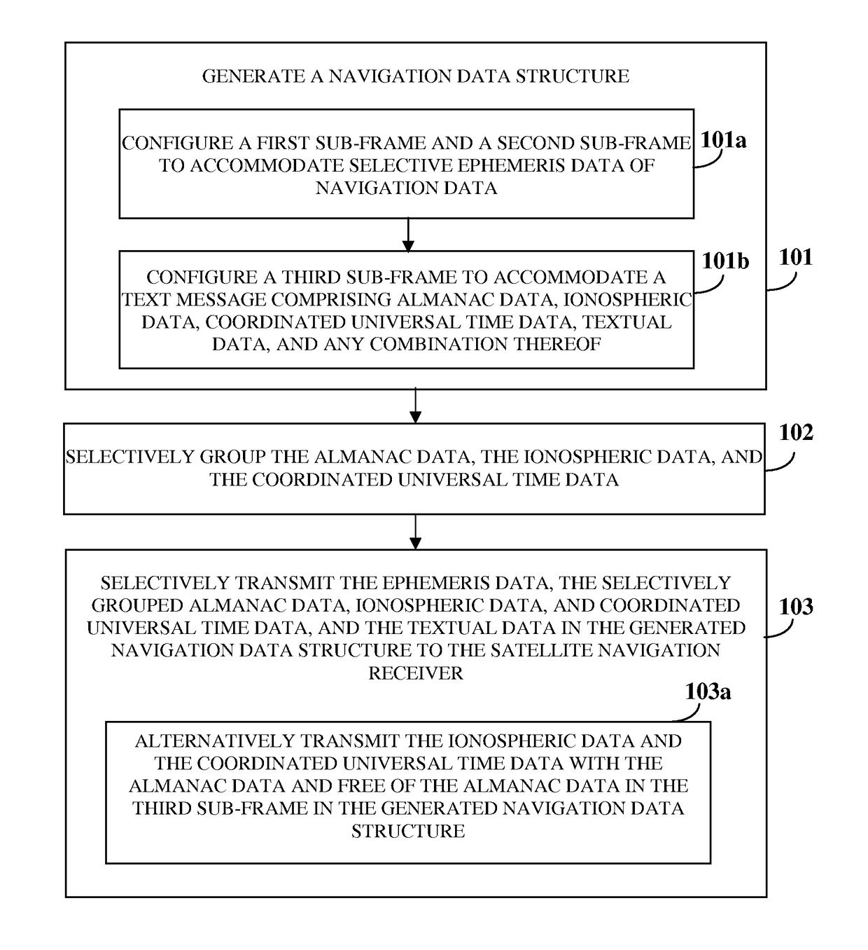
[0050]FIG. 1 illustrates a method for reducing time to first fix (TTFF) in a satellite navigation receiver, for example, a single or dual frequency Indian regional navigational satellite system (IRNSS) receiver. The method disclosed herein reduces the TTFF by reducing ephemeris time Teph of the satellite navigation receiver in a single frequency mode of operation without increasing satellite data rate or power required for transmission of navigation data by the satellites. An optimal TTFF, that is, a minimal time required to transmit navigation data for “n” visible satellites with “j” sub-frames is computed using the formula below:

TTFFopt=mintΣnΣjSFj-enc

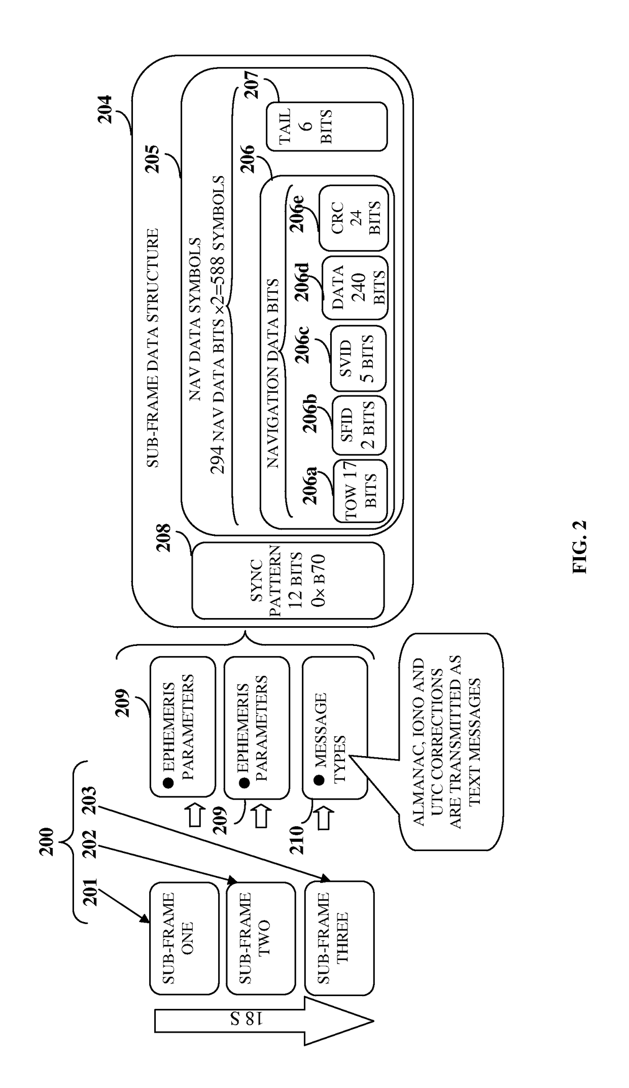
[0051]The navigation data transmitted by each satellite comprises primary navigation data and secondary navigation data. The ephemeris and clock parameters of the satellites constitute the primary navigation data whereas almanac data, coordinated universal time (UTC) data, ionospheric data such as correction terms, and message type ...


PUM


Abstract

A method and a system for reducing time to first fix (TTFF) in a satellite navigation receiver generate a navigation data structure including three sub-frames. A first sub-frame and a second sub-frame accommodate selective ephemeris data. The third sub-frame accommodates a text message including almanac data optionally, ionospheric data, coordinated universal time (UTC) data, textual data optionally, and any combination thereof. A signal generation system (SGS) in the system selectively groups the almanac data, the ionospheric data, and the UTC data, and selectively transmits the navigation data with the almanac data or free of the almanac data in the navigation data structure to the satellite navigation receiver. The signal generation system also staggers the navigation data in each sub-frame into a first portion and a second portion for parallelly transmitting the navigation data over a first carrier frequency and a second carrier frequency in reduced time.

Description

CROSS REFERENCE TO RELATED APPLICATIONS[0001]This application claims the benefit of the following patent applications:[0002]1. Non-provisional patent application number 2011 / CHE / 2013 titled “Navigation Data Configuration For Optimal Time To First Fix”, filed in the Indian Patent Office on May 6, 2013.[0003]2. Non-provisional patent application number 4231 / CHE / 2011 titled “Navigation Data Structure Generation and Data Transmission For Optimal Time To First Fix”, filed on 5 Dec. 2011 in the Indian Patent Office.[0004]3. Non-provisional patent application number 4230 / CHE / 2011 titled “Satellite Navigation System For Optimal Time To First Fix Using Code And Carrier Diversity”, filed on 5 Dec. 2011 in the Indian Patent Office.[0005]The specifications of the above referenced patent applications are incorporated herein by reference in their entirety.BACKGROUND[0006]Autonomous regional satellite based navigation systems have enabled several countries to cover their territorial footprint and ...

Claims


Application Information

Patent Timeline
Patent Type & Authority Patents(United States)
IPC IPC(8): G01S19/24G01S19/05
CPCG01S19/05
Inventor RAO, VYASARAJ GURUMAA, SASHIDHARANLACHAPELLE, GE'RARD
Owner ACCORD SOFTWARE & SYST PVT
Why Eureka
Try Eureka