Coding system for satellite navigation system

a satellite navigation and coding technology, applied in the field of georeferencing systems, can solve the problems of difficult human work, large number of characters, and more expensive means of identifying each address relative to other address estimation methods, so as to improve accuracy, increase accuracy, and increase the degree of location accuracy

Active Publication Date: 2018-04-24
HALE MERTON G
View PDF24 Cites 0 Cited by
  • Summary
  • Abstract
  • Description
  • Claims
  • Application Information

AI Technical Summary

Problems solved by technology

There are obvious errors to this system, the main one being that the house numbers are probably not evenly distributed along the road.
This is why the satnav system does not always guide a user to exactly the “front door” of the address.
This is a more expensive means of identifying each address relative to other address estimation methods, as each address will need to be individually identified and located.
Such large numbers of characters are difficult for humans to work with, prone to errors and are not “user friendly”.
Obviously a large number of characters are required to encode this data.
All current geocoding methods suffer from the same weakness from a human user's point of view—the codes require too many characters to geotag a location.

Method used


Image

  • Coding system for satellite navigation system
  • Coding system for satellite navigation system
  • Coding system for satellite navigation system

Examples


Embodiment Construction

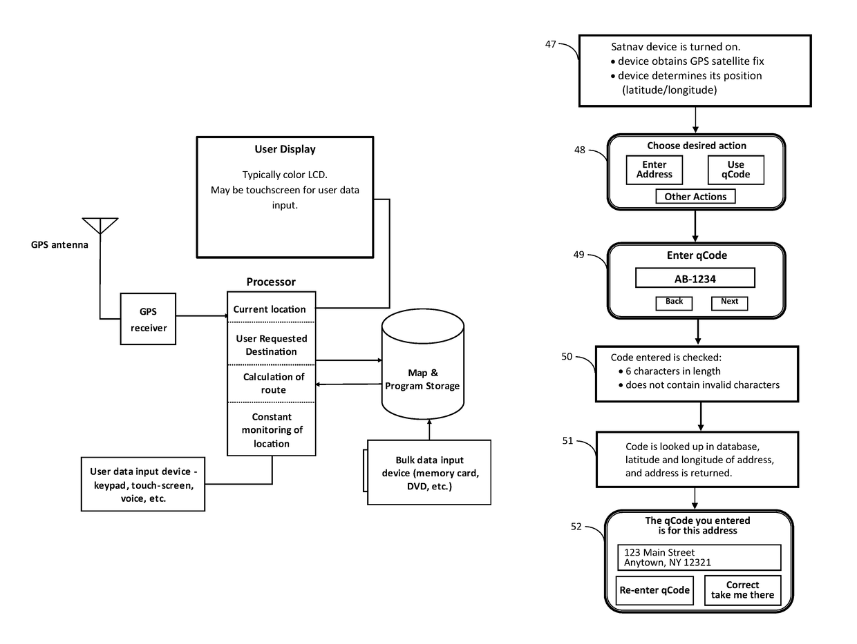
[0123]FIG. 1 depicts the components of a typical satnav system. A typical satnav device has a user display, a processor to run software which operates the satnav device, a user data input device such as an touchscreen keypad, a bulk data input device such as a memory card, map and program storage comprising read only memory (ROM) for the software running the satnav system and random access memory (RAM) to store user entered data and working data, a power supply (not depicted) which may be an internal battery or an external power source such as an automotive electrical system, and a GPS receiver which receives location information from a GPS satellite network (not depicted) via a GPS antenna. The satnav device could be a personal GPS system, or an application that runs on a smartphone, tablet, or other like device.

[0124]When the GPS receiver is activated, the GPS receiver receives radio signals via the GPS antenna. This allows the GPS Receiver to determine where it is on the surface ...


PUM


Abstract

The present invention provides a method, the QCODE method, of geotagging all postal addresses and other points of interest that one might want to navigate to and which allows the user to identify these addresses and other points of interest with a code consisting of 6 alphanumeric characters or less. A point of interest may or may not have a street address, for example, “the main entrance to the Jefferson Building at the USPTO complex in Alexandria Virginia” or “the entrance to the VIP parking area at Yankee Stadium”. The disclosure teaches embodiments that are naturally upgraded to integrate changing spatial information due to addition of countries, better data, political changes, and other similar changes in geographical data. A single geocoding engine is capable of handling the various address formats in use in different countries and jurisdictions.

Description

CROSS-REFERENCE TO RELATED PATENT APPLICATIONS[0001]Priority for this patent application is based upon provisional patent application 61 / 736,539 (filed on Dec. 12, 2012); provisional patent application 61 / 754,157 (filed on Jan. 18, 2013); and PCT application PCT / US2013 / 074234 (filed on Dec. 11, 2013); and of U.S. Non-provisional patent application Ser. No. 14 / 651,110, filed Jun. 10, 2015. The disclosure of these United States patent applications is hereby incorporated by reference into this specification.TECHNICAL FIELD[0002]The present invention relates to geographic referencing systems and, more particularly, to a method and system for providing an indication of location, so as to facilitate operation of such location-based services.BACKGROUND ART[0003]A detailed description of the current state of the art in geocoding is provided in ‘The Geocode Encyclopedia: A Research for Geographic Entity Object code Systems and Evaluation Perspectives version 1.1’ by Naoki Ueda.[0004]The prol...

Claims


Application Information

Patent Timeline
Patent Type & Authority Patents(United States)
IPC IPC(8): G01C21/00G01C21/32G06F17/30G01C21/36
CPCG01C21/32G01C21/00G06F17/3087G06F17/30G01C21/3617G06F16/29G01C21/3811G01C21/3874G06F16/00G06F16/9537
Inventor HALE, MERTON G
Owner HALE MERTON G
Why Eureka
Try Eureka