
Method for fine correcting satellite remote sensing image geometry based on topographic line

A satellite remote sensing and image technology, which is applied in the field of data recognition of satellite remote sensing images, can solve the problems of low work efficiency, large data errors, and projection differences affecting the effect of geometric fine correction, etc., to achieve convenient selection, realize geometric fine correction, and improve matching The effect of quasi-precision

Inactive Publication Date: 2009-07-29
SOUTHWEST FORESTRY UNIVERSITY
View PDF5 Cites 0 Cited by
  • Summary
  • Abstract
  • Description
  • Claims
  • Application Information

AI Technical Summary

Problems solved by technology

In the application of remote sensing data, it is generally believed that the basic geographic base map is data without error and deformation, and the obvious features that can be identified on satellite images such as river networks, road networks, and lakes on the basic geographic base map are used to control and correct satellite remote sensing data. Image is a general correction method, but in mountainous areas, the lack of control points is difficult to find, and the lack of control points affects the quality of satellite image correction
In mountainous areas, the projection difference caused by the change of terrain elevation further affects the effect of geometric fine correction
Digital terrain model, DEM (Digital Elevation Model) is the most stable data in the geographic basemap, it contains all the feature point lines of the terrain changes on this scale, that is, the ground line, the geometric fine correction control point file in the prior art Acquisition relies on visual recognition and computer interaction, and often uses characteristic points and lines such as river networks, road networks, and lakes to find and collect control points, which are often affected by human subjective judgments and difficult operations, resulting in low work efficiency and large data errors

Method used


Image

  • Method for fine correcting satellite remote sensing image geometry based on topographic line
  • Method for fine correcting satellite remote sensing image geometry based on topographic line
  • Method for fine correcting satellite remote sensing image geometry based on topographic line

Examples


Embodiment Construction

[0020] Further description will be made below in conjunction with the accompanying drawings.

[0021] (1) Utilize the present invention to the data processing of the satellite remote sensing image of Anning City area

[0022] Anning City, Yunnan Province is adjacent to Kunming, and is located between 102°10′-102°37′ east longitude and 24°31′-25°06′ north latitude. It is located on the eastern edge of the Central Yunnan Plateau. The terrain within the territory is broken and belongs to Zhongshan landform.

[0023] The following data processing uses Arc / Info, an American Esri company, as a platform.

[0024] 1. Data preparation

[0025] System-level corrected ETM (Enhanced Thematic Mapper) satellite remote sensing image, satellite orbit number (WRS) 129 / 043, array size 6969 columns × 5965 rows, sun elevation angle SUN ELEVATION = 52.4, sun azimuth angle SUNAZIMUTH = 139.8, scene center The location is 103 degrees 5 minutes 0 seconds east longitude and 24 degrees 33 minutes 0 s...


PUM


Abstract

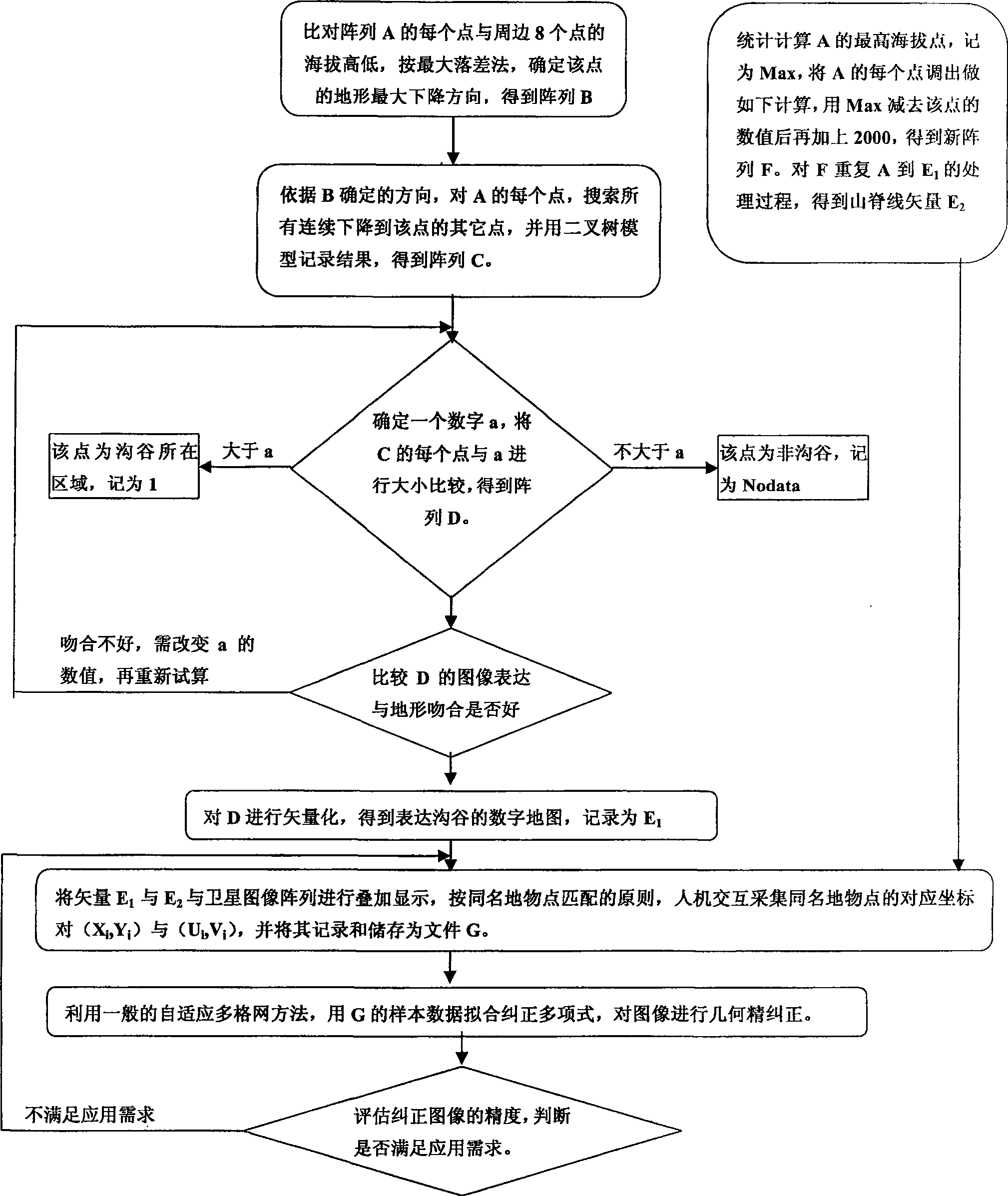
A geometric precise-correcting method of satellite remote sensing image based on form line includes calling on digital DRM, confirming maximum dropping direction, storing drop amount as C, confirming threshold a by man-machine interaction, storing comparison result of C and a as D, vectoring D to obtain valley linear file E, obtaining array F by calculation on highest mass point Max of A, repeating above said step to obtain peak linear file E2, superposing called on satellite image with vector E1 and E2, storing surface feature coordinate as G and carrying out fitting-correction.

Description

technical field [0001] The invention belongs to a method for checking the correctness of marks on a record carrier, in particular to a data identification method for satellite remote sensing images. Background technique [0002] Satellites observe the ground from hundreds of kilometers to thousands of kilometers above the ground. Affected by factors such as the rotation of the earth, the curvature of the earth's surface, the fluctuation of the terrain, the refraction of the atmosphere, and the changes in the orientation elements inside and outside the sensor, remote sensing images often produce geometric out of shape. The precise geometric correction of satellite remote sensing images to make them strictly registered with the basic geographic base map, to ensure the correctness and reliability of the area, length, position, and spatial relationship geometric measurements of remote sensing satellite data, has become the basis of remote sensing applications. In the applicatio...

Claims


Application Information

Patent Timeline
Patent Type & Authority Patents(China)
IPC IPC(8): G01C11/00G06T5/00
Inventor 周汝良
Owner SOUTHWEST FORESTRY UNIVERSITY
Learn More