Map information correction device, map information correction method, program, information providing device and information acquisition device using the map information correction device

A technology of map information and correction device, which is applied in the directions of maps/plans/charts, measuring devices, educational appliances, etc., and can solve problems such as difficulty in accurately specifying the position of objects

Inactive Publication Date: 2007-08-01
PANASONIC CORP
View PDF1 Cites 27 Cited by
  • Summary
  • Abstract
  • Description
  • Claims
  • Application Information

AI Technical Summary

Problems solved by technology

[0006] Therefore, when the position of the object is specified on the map of the user device based on the position information (such as latitude and longitude information) transmitted from

Method used


Image

  • Map information correction device, map information correction method, program, information providing device and information acquisition device using the map information correction device
  • Map information correction device, map information correction method, program, information providing device and information acquisition device using the map information correction device
  • Map information correction device, map information correction method, program, information providing device and information acquisition device using the map information correction device

Examples


no. 1 example

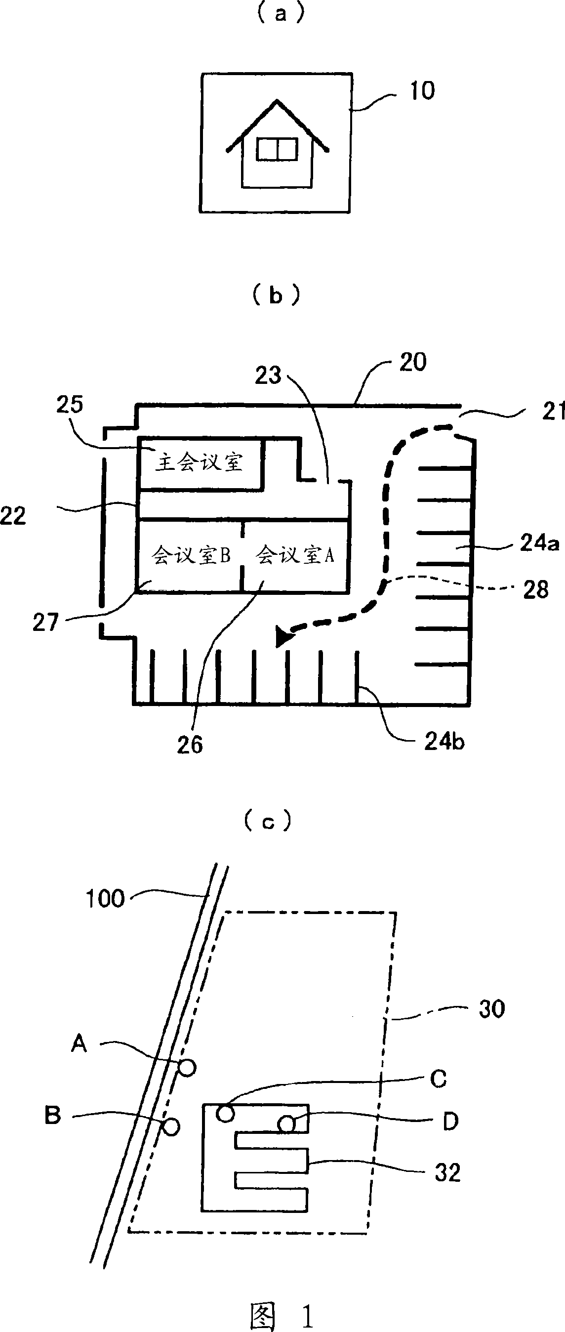
[0086] First, provision of POI information will be explained. 1(a)-1(c) are diagrams illustrating examples of representations of POIs (points of interest) such as restaurants or scenic spots. Specifically, FIG. 1(a) is a diagram illustrating an image represented by dots according to the prior art, FIG. 1(b) shows a plan view image of a POI (building), and FIG. 1(c) is a POI (place) and a floor plan of the road near the POI.

[0087] As shown in FIG. 1( a ), in the prior art, a POI (such as a restaurant or a scenic spot) is represented by an icon 10 .

[0088] That is, POIs are represented by dots. Since the position of the POI is indicated only by a point, the amount of information that can be indicated is small.

[0089] Therefore, in this embodiment of the present invention, it is assumed that plan view POI information capable of representing complex structures is provided.

[0090] That is, in this embodiment, it is assumed that the following services are provided hierarc...

no. 2 example

[0192] In the second embodiment, various variations of the method of interpolating (correcting) or specifying a position using a road shape will be described.

[0193] 11(a)-11(c) are diagrams illustrating a problem caused when a detailed road network not marked on the second map is displayed on the second map.

[0194] FIG. 11( a ) shows a main road (indicated by a thick line) RD1 and a narrow road (road network) RS1 existing within the main road RD1 on the first map.

[0195] FIG. 11( b ) shows the arterial road QD1 (corresponding to the arterial road RD1 shown in FIG. 11( a ) and represented by a thick dashed line) on the second map.

[0196] The shape of the arterial road QD1 on the second map is not exactly the same as the shape of the arterial road RD1 on the first map (due to errors between maps).

[0197] Also, the accuracy of the second map is lower than that of the first map, and the narrow road RS1 existing on the first map is not on the second map.

[0198] Accor...

no. 3 example

[0246] In this embodiment, a basic example of the structure and operation of the map information communication system (map information using system) and the data structure of the provided map information will be described below.

[0247] Fig. 15 is a block diagram illustrating the structure of a map information communication system (map information using system).

[0248] As shown in Figure 15, the information providing device 500 on the map information provider side includes: an object determination unit 502 for determining an object as an information receiver; an object database 503; a data extraction unit 504 (including external position reference information extraction unit 505 and internal shape extraction unit 506); digital map database A (reference number 507) and position information sending unit 508.

[0249] The information acquiring device 600 on the map information receiver side includes a position information receiving unit 601, an outline position specifying unit...


PUM


Abstract

A map information correction device, a map information correction method, a program, an information providing device using the program, and information acquisition device, in which displacement of an object caused by an error between different maps is correctable. An information acquisition device (600) has a positional information receiving section (601) for receiving information on an object including outline position reference information for referring a position near the object, the information on an object corresponding to a digital map database (A507) on the information provider side; an outline position specifying section (602) for specifying an outline position; a representative position extraction section (604) for extracting a representative point from the outline position; and an inner shape correction section (605) for performing interpolation processing by the use of information on positions in digital map database (A507) and in digital map database (B603) and correcting at least either the position or the shape of the object so that it fits a second map.

Description

technical field [0001] The present invention relates to a map information correction device, a map information correction method, a program, an information providing device and an information acquisition device using the map information correction device. Background technique [0002] A Vehicle Information Communication System (VICS) that provides traffic information such as information on traffic congestion or information on traffic control through a dedicated receiver has been used as an Intelligent Transportation System (ITS). [0003] In the vehicle information communication system, when the VICS center (traffic information providing center that performs centralized management for traffic information) edits and processes traffic information in real time and transmits the processed traffic information, on the map used by the car navigation system Traffic information is displayed as graphics or characters, so routing guidance is performed in consideration of information on...

Claims


Application Information

Patent Timeline
IPC IPC(8): G09B29/00G06T11/60G01C21/00G09B29/10
CPCG01C21/30G06T17/05G09B29/106
Inventor 足立晋哉高部佳之山下哲郎
Owner PANASONIC CORP
Why Eureka
Try Eureka