Data warehouse system and its construction for geographical information system

A geographic information system and data warehouse technology, applied in the direction of electrical digital data processing, special data processing applications, instruments, etc., can solve the problems of consuming system resources and time, and reducing query and analysis efficiency, so as to improve efficiency and avoid consumption Effect

Inactive Publication Date: 2007-11-21
SHANGHAI TRIMAN INFORMATION & TECH
View PDF0 Cites 23 Cited by
  • Summary
  • Abstract
  • Description
  • Claims
  • Application Information

AI Technical Summary

Problems solved by technology

However, because the data model of this type of system is centered on geographic entities, it does not organize and store geographic entities and express geographic space based on topological relationships. Therefore, topological relationships do not exist at the beginning, but are temporary when needed. Exporting various topological relationships consumes certain system resources and time and reduces the efficiency of query and analysis

Method used


Image

  • Data warehouse system and its construction for geographical information system
  • Data warehouse system and its construction for geographical information system

Examples


Embodiment Construction

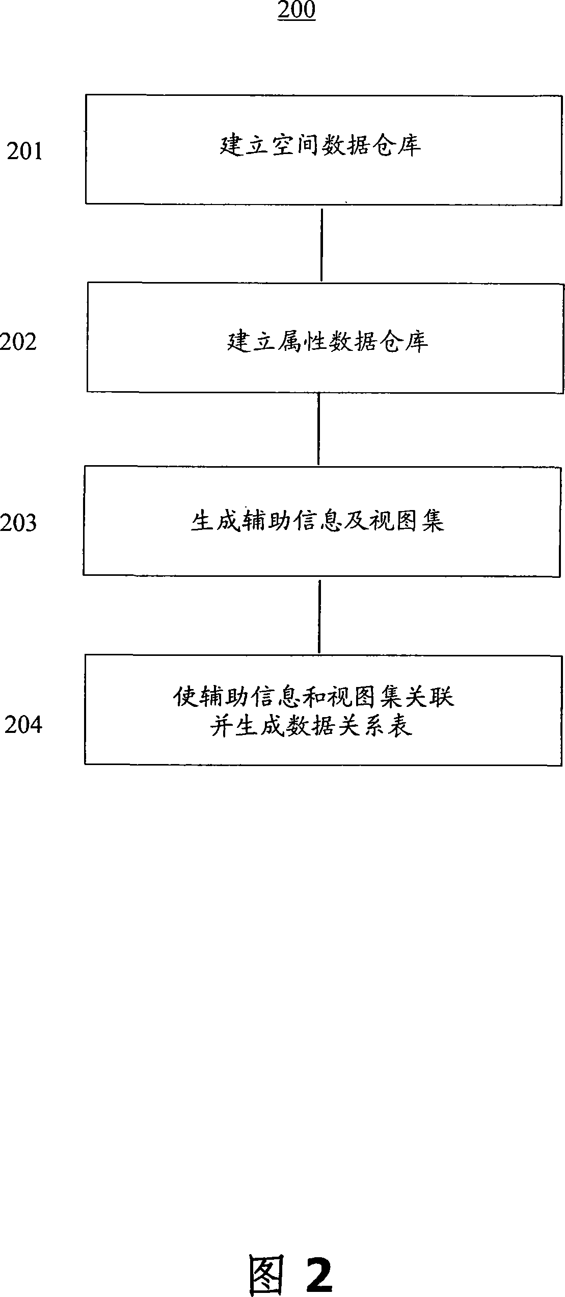
[0027] The technical solutions of the present invention will be further described below in conjunction with the accompanying drawings and embodiments.

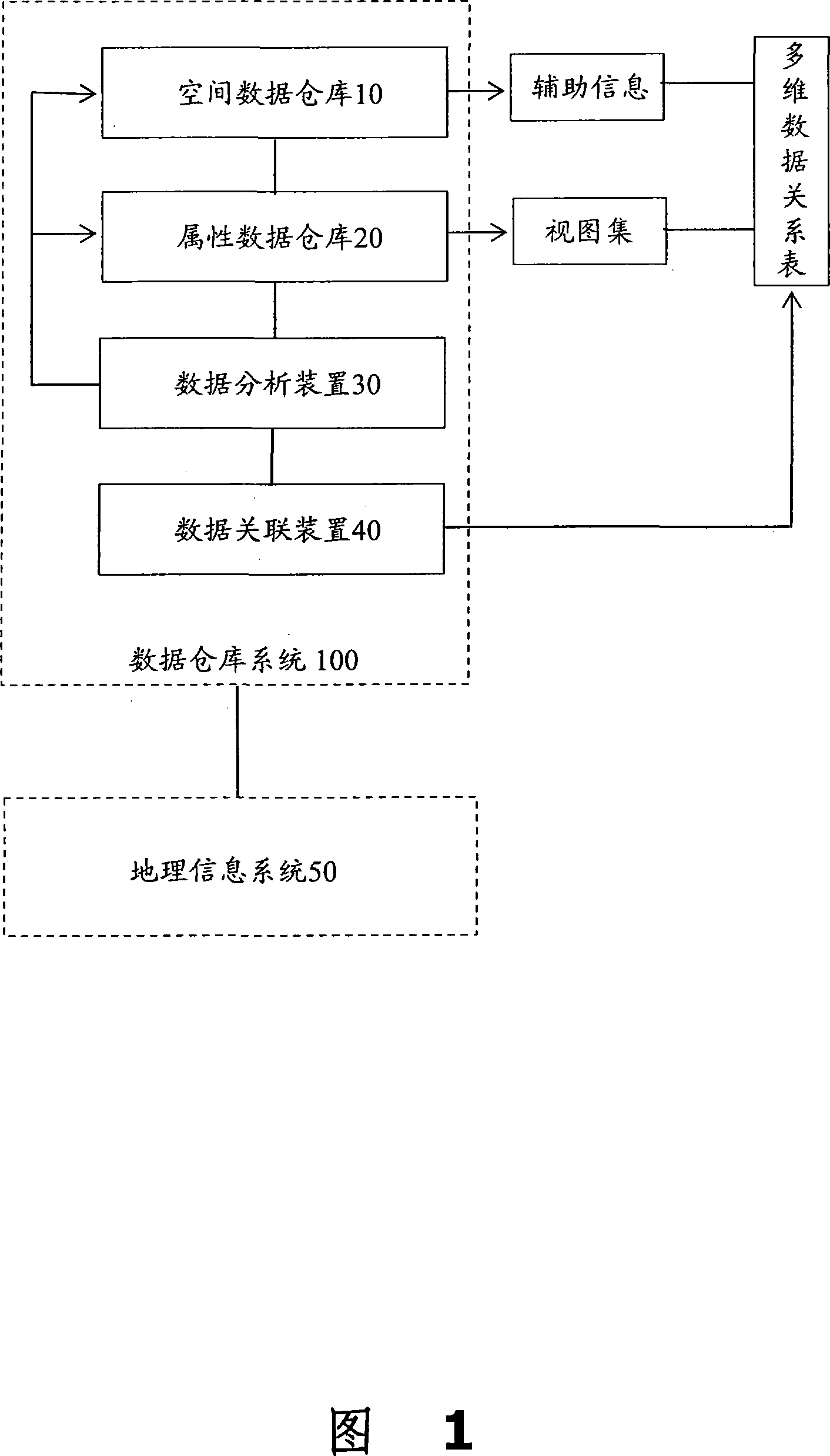
[0028] Referring to FIG. 1 , the dotted box part in FIG. 1 discloses a data warehouse system 100 of a geographic information system for calling by a geographic information system 50 .

[0029] The data warehouse system 100 includes a spatial data warehouse 10, an attribute data warehouse 20, a data analysis device 30 and a data association device 40, all of which are connected to each other.

[0030] The spatial data warehouse 10 is used to store spatial geometric data of geographic spatial entities. The spatial geometry data of the spatial data warehouse 10 represents the location, size, shape, direction and topological geometric relationship of the geographic spatial entity. The main design purpose of the spatial data warehouse 10 is the conversion of spatial data and the connection with attribute data. An embodiment of th...


PUM


Abstract

A databank unit of geographic information system consists of space databank for storing space geographic data of geographic space entity, attribute databank for storing attribute data of geographic space entity, data analysis unit for generating auxiliary information of space geographic data and view set of attribute data according to preset application requirement, data correlation unit for making auxiliary information be correlated with view set and for generating multidimensional data relation-table.

Description

technical field [0001] The present invention relates to the management and processing technology of data information, more specifically, relates to a data warehouse system of geographic information system and its construction method. Background technique [0002] Geographic Information System (GIS) is an information system. Geographic Information System (GIS) is a variety of spatial data that reflect the current situation and changes of the real world (resources or environment) that people live on and attributes that describe the characteristics of these spatial data. With the support of computer software and hardware, it is a technical system for inputting, storing, retrieving, displaying and comprehensively analyzing applications in a certain format. GIS has the following characteristics: spatial visualization, spatial orientation, and spatial thinking. As an information system, GIS takes the real world as the research target and uses the binary digital world inside the c...

Claims


Application Information

Patent Timeline
Patent Type & Authority Applications(China)
IPC IPC(8): G06F17/30
Inventor 张殊南陈忠夏晔徐强胡大金王智博
Owner SHANGHAI TRIMAN INFORMATION & TECH
Why Eureka
Try Eureka