One-time all-polarization synthetic aperture radar image inverse method for digital elevation model

A technology of synthetic aperture radar and digital elevation model, applied in the direction of reflection/re-radiation of radio waves, utilization of re-radiation, measurement devices, etc., can solve complex problems and achieve easy-to-implement effects

Inactive Publication Date: 2010-06-16
中国科学院中国遥感卫星地面站
View PDF3 Cites 2 Cited by
  • Summary
  • Abstract
  • Description
  • Claims
  • Application Information

AI Technical Summary

Problems solved by technology

However, this method needs to use complex digital image processing technology when extracting the horizontal azimuth γ

Method used


Image

  • One-time all-polarization synthetic aperture radar image inverse method for digital elevation model
  • One-time all-polarization synthetic aperture radar image inverse method for digital elevation model
  • One-time all-polarization synthetic aperture radar image inverse method for digital elevation model

Examples


Embodiment Construction

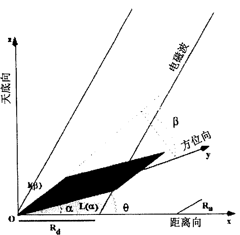
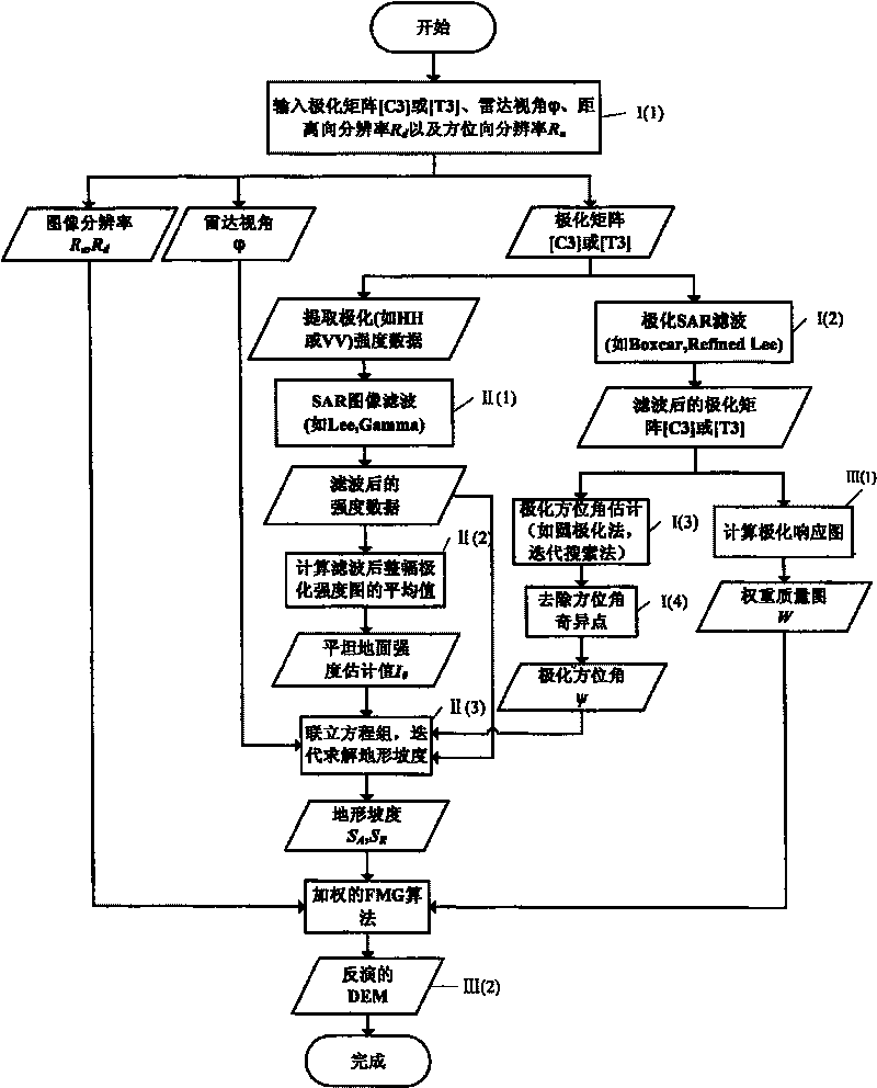
[0025] The present invention will be specifically described below with reference to the accompanying drawings. According to the method of the present invention, at first, the polarization azimuth angle ψ offset is estimated from the polarimetric SAR image by using the circular polarization method, and the polarization azimuth angle ψ offset and the terrain slope are established, that is, the range gradient angle α and the azimuth direction Data relationship between slope angle β. In the case of only a single full-polarization SAR image, assuming that the imaging area satisfies the conditions of homogeneity of surface coverage and small slope fluctuations, the Shape from Shading technology in radar angle measurement is introduced to establish the surface The data relationship between the backscattering intensity and surface geometric parameters (including range slope angle α and azimuth slope angle β). In this way, from the above two data relationships, the range gradient α an...


PUM


Abstract

The invention relates to a method of composing inversion digital elevation model of aperture radar image from single full-polarization by combining respective characteristics of radar polarization andradar angle-measurement technology. Polarization azimuth offset psi is estimated from polarization SAR data by using circular polarization method to build data relationship between polarization azimuth offset psi and range slope angle alpha and azimuth slope angle beta . Under the condition that there is only single full-polarization SAR image, suppose that imaging region satisfies conditions ofsurface covering homogeneity and little slope fluctuation and the technology from shadow to image in radar angle measurement is inducted to build data relationship of surface backward-scattering strength and surface geometric parameters (containing range slope angle alpha and azimuth slope angle beta ). In this way, by said data relationship range slope angle alpha and azimuth slope angle beta arecalculated. Weight graph is extracted from cross-polarization response signal graph and discrete poisson equation about ground elevation is solved by weighted least square algorithm to obtain DEM ininversion.

Description

technical field [0001] The invention belongs to the technical field of space remote sensing and image processing, and in particular relates to a method for acquiring a digital elevation model (DEM) through a synthetic aperture radar image. Background technique [0002] Synthetic Aperture Radar (SAR) is an active airborne or spaceborne sensor. Its basic principle is: the satellite regularly transmits electromagnetic wave pulse signals to the same ground object at different positions during orbital flight, and receives echo signals at the same time. In a sense, it can be considered as extending the length of the radar antenna, thus greatly improving the resolution. In addition, because synthetic aperture radar also has the advantages of being all-day, all-weather, not affected by atmospheric propagation and climate, and strong penetrating power, it is widely used in civil and military applications. [0003] Digital elevation model (Digital Elevation Model), referred to as DE...

Claims


Application Information

Patent Timeline
Patent Type & Authority Patents(China)
IPC IPC(8): G01S13/90
Inventor 张红陈曦王超
Owner 中国科学院中国遥感卫星地面站
Why Eureka
Try Eureka