Positioning and attitude determination and point cloud data real-time calculation and fusion method for mobile measurement

A point cloud data and mobile measurement technology, applied in the field of intelligent surveying and mapping, can solve the problems of complex operation process, low efficiency and poor real-time performance.

Pending Publication Date: 2021-09-10
WUHAN HI TARGET DIGITAL CLOUD TECH CO LTD
View PDF4 Cites 2 Cited by
  • Summary
  • Abstract
  • Description
  • Claims
  • Application Information

AI Technical Summary

Problems solved by technology

The traditional mobile measurement system has a complex operation process and requires local complex post-processing. While consuming a lot of manpower, material resources and time, there is a risk of rework and re-collection of data
Nowadays, the demand for fast and real-time performance is constantly increasing, such as emergency relief, accident investigation, environmental monitoring, power inspection, etc. The traditional mobile measurement system has the disadvantages of low efficiency and poor real-time performance.
[0004] Traditional positioning algorithms include pseudo-range single-point positioning algorithm and RTK positioning algorithm. RTK positioning solution needs to set up a base station, which has the characteristics of complex operation mode and high precision; Velocity and position information are obtained by multiplication. Error sources of pseudo-range observations include satellite clock error, error caused by earth rotation, ionospheric delay and tropospheric delay. Since the error term cannot be completely eliminated, the accuracy is general

Method used


Image

  • Positioning and attitude determination and point cloud data real-time calculation and fusion method for mobile measurement
  • Positioning and attitude determination and point cloud data real-time calculation and fusion method for mobile measurement
  • Positioning and attitude determination and point cloud data real-time calculation and fusion method for mobile measurement

Examples


Embodiment Construction

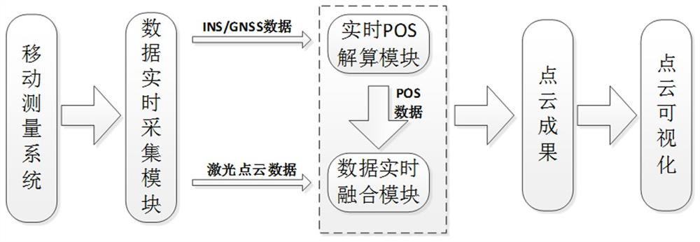
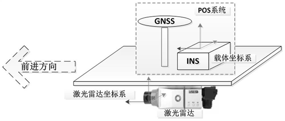
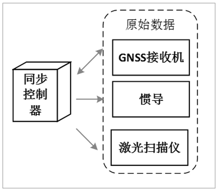
[0035] Such as figure 2 , 3 As shown, the mobile measurement system of the embodiment includes a GNSS receiver, an inertial navigation module and a laser scanner, and a position and orientation system (POS) is composed of the GNSS receiver and the inertial navigation module. The mobile measurement process adopts the carrier coordinate system. The origin of the inertial navigation coordinate system is used as the origin of the carrier coordinate system. The forward direction of the carrier is the positive direction of the Y axis, the right direction is the positive direction of the X axis, and the upward direction is the positive direction of the Z axis.

[0036] The world coordinate system of the embodiment is defined as follows: with the WGS-84 ellipsoid or CGCS2000 as the benchmark, set the central meridian according to the local longitude for projection such as Gauss projection or transverse Mercator projection, plus the local elevation system to form a plane A three-dime...


PUM


Abstract

The invention relates to a positioning and attitude determination and point cloud data real-time calculation and fusion method for mobile measurement. The method comprises the steps of acquiring real-time GNSS data, INS data and laser point cloud data by using a mobile measurement system; calculating the GNSS data and the INS data respectively, and fusing the GNSS data and the INS data to obtain real-time position, speed and attitude information; matching points of the laser point cloud with real-time positioning data obtained by mobile measurement, and fusing the laser point cloud data with absolute position and attitude information obtained by calculation to obtain real-time point cloud data with absolute coordinates; and sending the real-time point cloud data with the absolute coordinates to a display terminal through wireless communication, and decoding and visualizing the real-time point cloud data on the display terminal to obtain a three-dimensional scene. The surveying and mapping data are collected and processed at the same time, the three-dimensional scene of a surveying area is obtained in real time, the real-time performance is good, and the efficiency is high; and the surveying and mapping requirements in the fields with high real-time requirements such as emergency rescue and electric power inspection can be met.

Description

technical field [0001] The invention belongs to the field of intelligent surveying and mapping, and in particular relates to a positioning and attitude determination, point cloud data real-time calculation and fusion method for mobile measurement. Background technique [0002] As a technical means to collect spatial three-dimensional information, the mobile measurement system has a wide range of applications in digital cities, unmanned driving, topographic mapping and other fields. [0003] Traditional mobile surveying services, such as large-scale operation surveying and mapping, strip survey and inspection of road power, etc., all need to go through preparatory work such as erecting base stations and equipment installation in the early stage, collecting surveying and mapping data, and performing positioning data and laser scanner data. fusion, and finally obtain the labeled point cloud data. The traditional mobile measurement system has a complex operation process and req...

Claims


Application Information

Patent Timeline
Patent Type & Authority Applications(China)
IPC IPC(8): G01C15/00G06T15/00
CPCG01C15/00G06T15/00
Inventor 汪开理杨晶陈海佳翁国康
Owner WUHAN HI TARGET DIGITAL CLOUD TECH CO LTD
Why Eureka
Try Eureka