Quick cadastral survey measurement and data processing method based on real-time dynamic positioning technology

A real-time dynamic positioning and data processing technology, applied in the field of surveying and mapping, can solve the problems that the superiority of GPS has not been fully utilized, and the layout of map root points is time-consuming and labor-intensive, and achieve the effect of improving the degree of matching and the accuracy of mapping

Inactive Publication Date: 2008-01-16
SOUTHEAST UNIV
View PDF0 Cites 18 Cited by
  • Summary
  • Abstract
  • Description
  • Claims
  • Application Information

AI Technical Summary

Problems solved by technology

It can be seen that when the existing technology uses GPS-RTK for cadastral survey work, it is still subject to many restrictions. The superiority of GPS has not been well utilized, and the layout of map root points is still time-consuming and laborious.

Method used


Image

  • Quick cadastral survey measurement and data processing method based on real-time dynamic positioning technology
  • Quick cadastral survey measurement and data processing method based on real-time dynamic positioning technology
  • Quick cadastral survey measurement and data processing method based on real-time dynamic positioning technology

Examples


Embodiment Construction

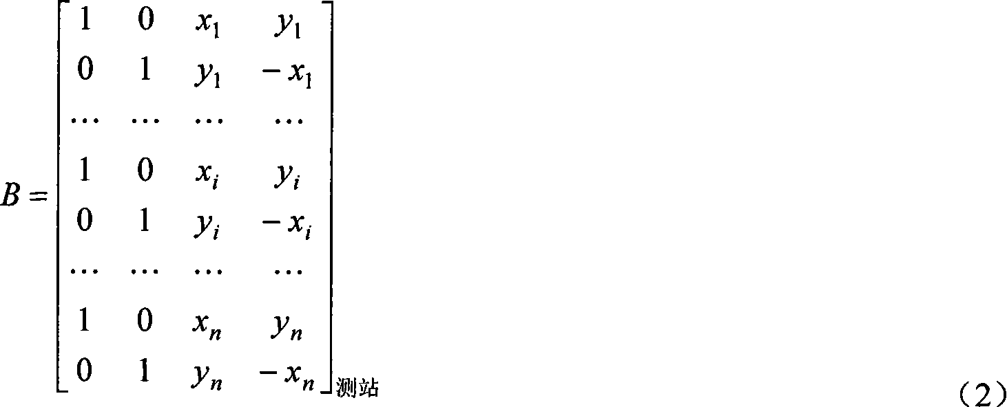
[0033] Below in conjunction with accompanying drawing, the working principle of the present invention and embodiment will be further described:

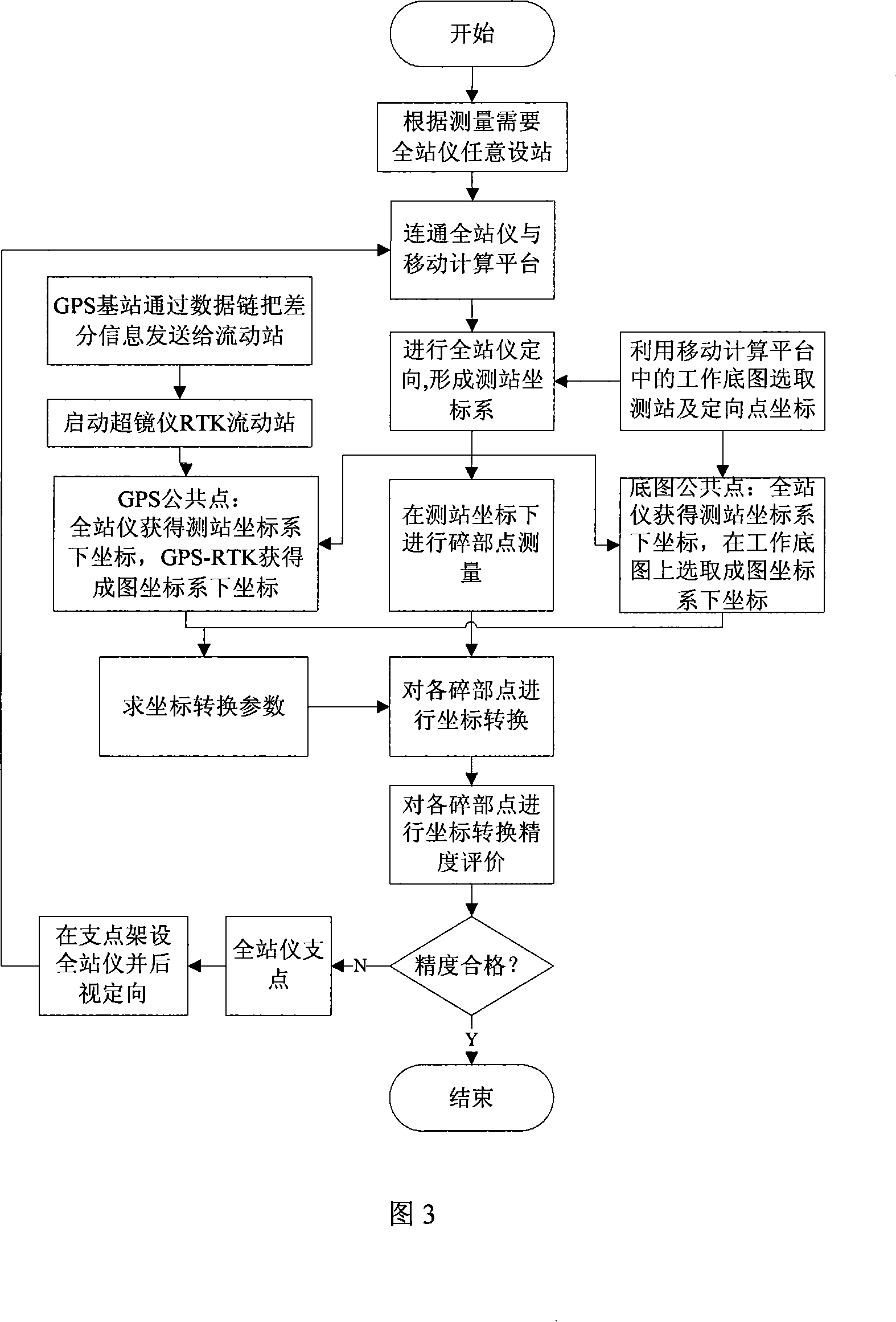
[0034] In this embodiment, the mobile computing platform selects the personal digital assistant (PDA), the working base map selects the urban cadastral current situation map, the total station selects the mirror-free total station, and the GPS-RTK records the coordinate transmission under the map coordinate system to the mobile computing platform. Select manual input for the transmission method.

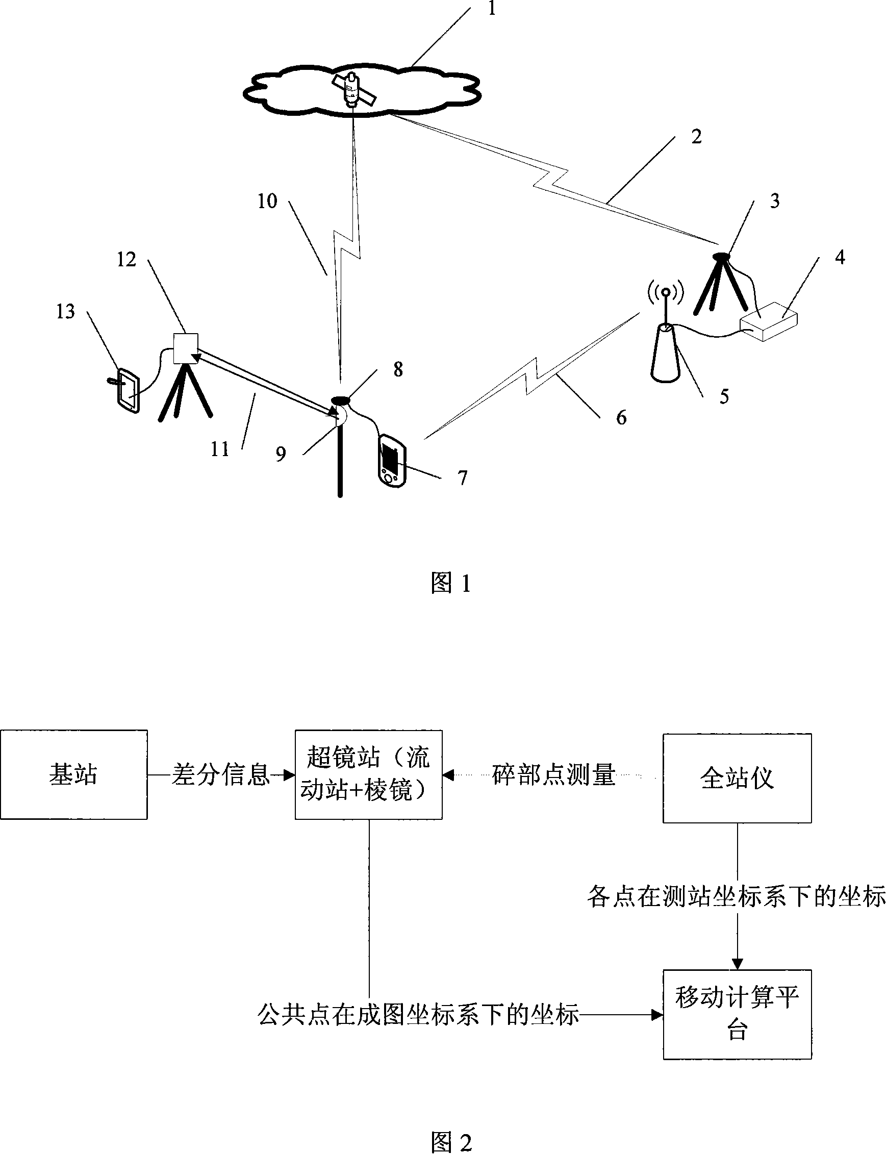
[0035] Fig. 1 is the device connection and working principle diagram of the present invention. Explanation of symbols: 1. GPS constellation, 2. GPS signal, 3. Base station antenna, 4. Base station host, 5. Data link, 6. Differential signal sent from base station to mobile station, 7. Rover host, 8. Rover antenna , 9. Total station reflecting prism, 10. GPS signal, 11. Total station ranging signal, 12. Total station, 13. PDA.

[0036] Set ...


PUM


Abstract

A rapid cadastral survey and data processing method based on the real time dynamic positioning technique comprises detail point survey by the cooperative utilization of GPS-RTK, working base map and a total station instrument; the method is characterized in that the total station instrument establishes a station at random, obtains approximate position and approximate orientation by the utilization of working base map and forms survey station coordinates system according to the survey requirement of detail points; in the course of detail point survey, coordinates of common points at mapping coordinate system are obtained by the utilization of GPS-RTK and working base map; the coordinates of the common points at survey station coordinates are obtained by the utilization of total station instrument; the coordinate transformation of detail points from survey station coordinate system to mapping coordinate system is completed by the utilization of the common points; transformation accuracy is valuated.

Description

technical field [0001] The present invention relates to surveying and mapping technology, in particular to a fast cadastral surveying and data processing method based on real-time dynamic positioning technology (GPS-RTK) which utilizes GPS and a total station to collect fragmentary points in the process of urban cadastral surveying and mapping. The field of surveying and mapping technology. Background technique [0002] With the rapid development of my country's national economy, it is urgent to find out the real estate of urban land and provide detailed data support for the planning and decision-making of government departments. At present, my country's urban cadastral data has undergone huge changes, and an efficient urban cadastral survey method using high-tech technology is needed to ensure that urban cadastral data is updated in a timely manner to meet the needs of urban construction. [0003] The advent of GPS global positioning technology, especially the development ...

Claims


Application Information

Patent Timeline
Patent Type & Authority Applications(China)
IPC IPC(8): G01S1/02G01S1/08G01C3/00G08C17/02G01S19/42
Inventor 王庆于先文吴向阳
Owner SOUTHEAST UNIV
Why Eureka
Try Eureka